Castlefield is easiest to misread from above. The Deansgate-Castlefield tram stop gives you platforms, glass, viaduct lines, and quick skyline angles; the basin below gives you something better: the small working section where Manchester lets Roman ground, canals, rail, warehouses, apartment blocks, and evening drinkers occupy the same few minutes of walking.
Keep the route tight. This is not a bar crawl, not a full canal itinerary, and not a substitute for the currently closed Castlefield Viaduct garden. The anchor is Castlefield basin itself, with Deansgate-Castlefield as the useful upper entry point. Local review and local-guide surfaces are helpful here because they show the same practical pattern again and again: people come for the canal atmosphere, short walking loops, and pub-lined edges, but the place works best when you already know which level you are trying to occupy.[1][2]
Start around 17:15-18:00 on a dry weekday or Sunday shoulder. If you arrive by tram, use Deansgate-Castlefield as the first navigation cue rather than St Peter's Square or Piccadilly. TfGM's stop page is useful because it confirms the tram stop as a live Metrolink access point, not just a name on a map.[4] Local move one: pause on the upper approach for 2 minutes, then go down. The reward is not the elevated view; it is the descent from transport infrastructure into canal level.
Local move two: do the basin before the drink. Castlefield has enough terraces and waterside tables to pull you sideways, especially after work. Resist for 20-25 minutes. Walk the water edge, cross one footbridge, look back at the tram viaduct, then decide whether you want a seat. If you sit first, Castlefield becomes an outdoor bar with heritage around it. If you walk first, the bars become just one layer in a more interesting machine.
The city-specific texture is unusually dense. Manchester City Council's conservation-area history ties Castlefield to the Roman fort of Mamucium, the Bridgewater Canal's arrival in the industrial city, and the later rail viaducts that made the district a visible pile-up of transport systems.[3] That is why the basin should not be treated as a generic "nice canal." It is a compact version of Manchester's operating system: water freight, rail pressure, reused brick, modern flats, and public leisure all sharing one cut of ground.
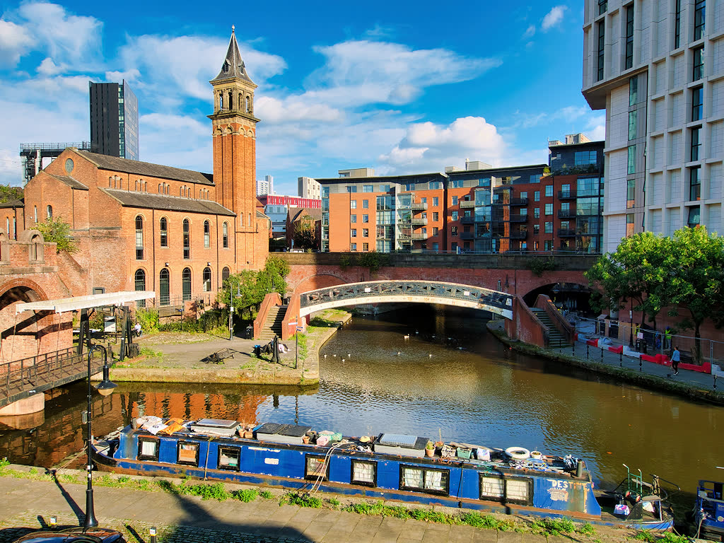
The image earns its place for exactly that reason. It shows a narrowboat on the water, St George's church tower, brick retaining walls, a pale footbridge, and newer apartment blocks in the same frame.[7] It is not a skyline postcard. It is a section drawing made by a camera, which is what a Castlefield visit needs.
Local move three: let the towpath set the speed. The Canal & River Trust's Castlefield walk describes a short route of about 1.5 miles, which is the right scale for a first visit.[5] You are not trying to prove endurance. Use a 45-70 minute loop: upper arrival, basin descent, one or two bridge crossings, a towpath segment, and a return to the tram or Deansgate.
Local move four: choose the side with an exit plan. The basin has corners that feel obvious in daylight and less obvious after a second drink or a sudden shower. Before you settle anywhere, know whether your return is back up to Deansgate-Castlefield, out toward Deansgate station, or onward along the canal. Use Google Maps only as a friction check, not as an invitation to expand the route into every nearby pub and bridge.[1]
Local move five: keep the closed viaduct out of the center of the plan. The National Trust's Castlefield Viaduct page says the sky-park section is closed until Autumn 2026 while the next phase is developed.[6] That matters because a visitor can still arrive expecting the old trial-visit script: book, enter, look down, leave. Better alternative: use the closure as a prompt to do the public basin properly. You can see the overhead rail structure and still have a complete visit at ground level.
Local move six: arrive before peak terrace noise if you want the canal to stay legible. On a workday, 17:15-18:30 gives you enough after-office life without turning the basin into only a drinks corridor. On a weekend, aim before 11:00 for a quieter read or after 16:30 for warmer light. Expected spend can be GBP 0 if you only walk; allow GBP 4-6 if you add a short tram ride, coffee, or a soft drink. The important budget boundary is not money. It is attention.
Local move seven: stand on bridges, not in the middle of bridge flow. The small crossings are the best reading points because they show the water, towpath, brick drops, and overhead city in one glance. Step to the edge before taking a photo. Let runners, residents, and people carrying drinks pass. Castlefield is photogenic, but it is also a residential and commuting passage.
Local move eight: use the tram stop as a reset, not a finish-line sprint. If you came by Metrolink, return upward while you still know exactly where you are. If you came on foot from central Manchester, the basin is a good 10-15 minute pause before continuing toward Deansgate, Spinningfields, or the Science and Industry Museum edge. The better rhythm is down, across, along, up. Do not zigzag until the water becomes background.
The non-local trapline is simple. Mistake one is building the visit around Castlefield Viaduct entry; better to check the National Trust status first and assume the basin is the open anchor until the closure changes.[6] Mistake two is coming only for a canal-side pint; better to walk 20 minutes before choosing a table so the Roman-industrial layers have time to appear.[2][3] Mistake three is treating the tram stop as the destination because the view is clean from above; better to descend and let the canal level explain why the stop matters.[4][5] Mistake four is starting too late on a Friday and blaming Castlefield for feeling crowded; better to use a weekday shoulder, a Sunday morning, or the early evening before the basin turns fully social.[1][2]
Concrete go details: best window 17:15-18:30 on a weekday, before 11:00 or after 16:30 on weekends; expected spend GBP 0-6 before any full meal; no reservation for the public walk; queue reality is mostly bar seating and narrow bridge pinch points, not an attraction line; stand on bridge edges, not in bridge flow; keep the route to 45-70 minutes; navigation cue is Deansgate-Castlefield tram stop -> descend to Castlefield basin -> one footbridge pause -> towpath segment -> return up to Deansgate or continue toward the museum edge.
Castlefield is not quiet because Manchester forgot it. It is quiet in the way a useful old junction can be quiet: everything still passes through, but at different speeds. The tram runs above, the canal holds the lower line, the old fort survives as a memory of ground, and the evening crowd keeps trying to turn the whole thing into one waterside table. Walk first, and the district keeps its shape.
Sources
- Google Maps, "Castlefield Urban Heritage Park Manchester" - current local map and review surface used for basin orientation, nearby approaches, and crowd/friction checks.
- Manchester's Finest, "A Finest Day Out in Castlefield" - local-guide source used for visitor patterns around canal atmosphere, short walking, terrace edges, and neighborhood framing.
- Manchester City Council, "Castlefield Conservation Area: History" - official local history reference for Mamucium, the Bridgewater Canal, rail viaducts, and Castlefield's layered transport landscape.
- Transport for Greater Manchester, "Deansgate-Castlefield tram stop" - official Metrolink stop page used for the upper access point, tram-stop framing, and live transport orientation.
- Canal & River Trust, "Canal walk from Castlefield" - canal-route reference used for the short-walk framing and the 1.5-mile Castlefield route scale.
- National Trust, "Castlefield Viaduct" - official current page used for the closure-until-Autumn-2026 status and the distinction between the closed sky-park visit and the open basin route.
- Wikimedia Commons, "File:Bridgewater Canal, Castlefield Basin (geograph 6966336).jpg" - real photographic source for the article image, showing Castlefield basin, a narrowboat, footbridge, brick canal edges, and Manchester's layered skyline.