Kuching's waterfront is easy to flatten into one postcard: river, lights, Darul Hana Bridge, the State Legislative Assembly building across the water. The better move is smaller. Let the perahu tambang do what it has always done for the city: make the Sarawak River feel like a short crossing before it becomes scenery.
This is a tight two-anchor route, and both anchors are non-food. The first is the perahu tambang, the little covered river taxi that links the south-bank waterfront with the Malay kampung side of the river. The second is Darul Hana Bridge, the pedestrian bridge that lets you return slowly above the same water. Done together, they turn Kuching from a riverfront view into a working cross-section: boat first, bridge second, skyline only after you have felt the river's width under your feet.
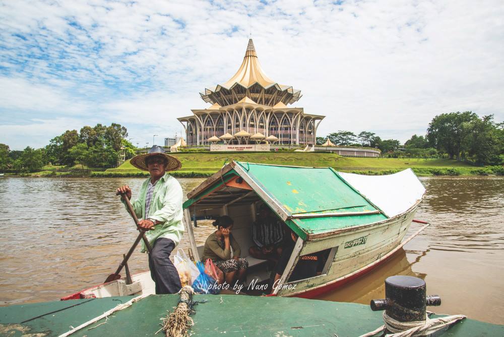
Start on the south bank around 17:15-17:30, not at noon. The Waterfront still has enough light to read the landing points, the river is beginning to lose its heat, and the north-bank buildings have not yet become pure night decoration. Use the Main Bazaar / Square Tower side as your first orientation cue, then look across to the Astana, Fort Margherita, and the umbrella roof of the State Legislative Assembly. The lead image belongs here because it shows the hierarchy correctly: the boatman and low wooden roof in the foreground, the monumental civic skyline behind, and the brown river doing the actual work between them.[7]
Local move one: carry small ringgit notes even if the rest of your Malaysia trip has gone mostly cashless. A Sarawak government-hosted Borneo Post report quoted a boatman charging RM1 for a one-way Waterfront-to-opposite-bank trip in 2024, while also describing the boats' solar lights, the old kerosene-light routine, and a state-backed facelift project involving 22 operators.[2] Treat RM1 as the public baseline, not as a promise that every moment and every routing will price exactly the same. The practical budget is still tiny: RM1-5 for a crossing, plus slack for a drink or snack if you linger near Kampung Boyan.
Local move two: do not ask for a "tour" when you really need a crossing. KuchingBorneo's local write-up describes the perahu penambang as a service across the Sarawak River linking Kuching city with the Malay villages opposite, not as a packaged cruise.[3] The ride is best when it stays short. Step down only when the boatman indicates, keep your weight low, keep bags between your feet, and do not make the doorway a photo platform while another passenger is trying to board.
Local move three: cross by boat before you walk the bridge. The order matters. If you use Darul Hana first, the river becomes an overhead view and the boat can feel like an optional novelty afterward. If you cross by boat first, the bridge becomes a comparison: the same river translated from hand-steered, low-roofed transport into a civic promenade.
Local move four: keep the phone wide and quiet. Photograph the roofline, wake, rope, landing edge, and skyline if you want, but ask before making the boatman or passengers your close-up subject. The point of the perahu tambang is not that it survived for visitors; it survived because the river remained a practical shortcut. That local texture is still visible even as the system modernizes. DBKU's 2025 E-Penambang notice says nine existing river taxis had been upgraded with electric systems, supported by Sarawak's first floating solar charging station at Kampung Sungai Bintangor Pontoon Jetty.[1] Sarawak Tribune's local report gives the engineering shape: a 3 kW electric propulsion system, 3 kWh lithium battery, 10 charging points, and a target of more electric river taxis by October 2025.[6]
Local move five: make the north-bank pause short unless you have a specific plan. Fort Margherita and the Astana can pull the eye into a heritage checklist, but this route works better as a river-reading loop than as a museum sprint. Give yourself 10-15 minutes after landing to look back at the south-bank shophouse line, then choose: return by bridge, or stay longer only if you already checked opening hours for the fort or planned food around Kampung Boyan.
Local move six: use Darul Hana Bridge as a return device, not only a light sculpture. The bridge engineer's project page describes Kuching as divided by the Sarawak River and Darul Hana as the connector between City North and City South. It also gives the object its useful scale: 337 metres including approach ramps, 267 metres for the main bridge, a 133-metre main span, 3.25 metres of width, and a final steel deck segment lifted into place in June 2017.[4] Those numbers explain why the return walk feels long enough to reset the view but short enough to stay inside one evening.
Local move seven: stop once on the bridge, then keep moving. The bridge has resting points and a panoramic view, but it is still a pedestrian connector. Stand to the side, let families and commuters pass, and do not block the curve for the same picture everyone else is trying to make. If rain comes in, the bridge is the safer fallback and the boat can wait for another evening.
Local move eight: end before the waterfront becomes only lights. The best first loop is 45-60 minutes: 5-10 minutes to orient on the south bank, a short boat crossing, 10-15 minutes on the north side, then 15-20 minutes back over Darul Hana with one proper pause. Google Maps is useful here as a live surface for the exact Kuching Waterfront pin, crowd feel, and walking navigation back to Main Bazaar or your ride pickup, especially because the river edge can look deceptively simple after dark.[5]
The non-local trapline is predictable. Mistake one is arriving in the full afternoon heat because the waterfront looks close on a map. Better alternative: use the 17:15-19:00 window, when visibility, temperature, and lights overlap. Mistake two is treating the perahu tambang as a preserved prop. Better alternative: pay small cash, take the short crossing, and let the boat remain transport.[2][3] Mistake three is walking only the bridge because it is free and obvious. Better alternative: use both modes; the low crossing makes the high return mean more.[1][4] Mistake four is building the evening around one perfect skyline photo. Better alternative: watch how the river changes roles in under an hour, from shortcut to civic stage to night mirror.
Concrete go details: best window 17:15-19:00; expected spend RM1-5 for the boat crossing and RM0 for the bridge; no reservation for a simple crossing; carry small cash; board from the south-bank Waterfront landing; ask or gesture for the opposite bank rather than negotiating a cruise; keep the north-bank pause short unless you have checked a specific venue; use Darul Hana Bridge for the return; navigation cue is Main Bazaar / Square Tower side -> perahu tambang landing -> north-bank kampung side -> Darul Hana Bridge -> Waterfront lights -> Main Bazaar.
Kuching's cleanest evening lesson is that the river is not just the view. It is the old street between two banks. The bridge made that street visible from above; the perahu tambang keeps it human-scaled below. Use both, and the waterfront stops being a backdrop. It becomes a small piece of city machinery still doing its work.
Sources
- Commission of the City of Kuching North, "Nine river taxis in Kuching go electric..." - official DBKU news page used for the August 2025 E-Penambang upgrade, nine converted boats, floating solar charging station, and project partners.
- Council for Native Customs and Traditions, "Iconic Sarawak 'perahu tambang' boats embrace modern tech" - Sarawak government-hosted Borneo Post/Bernama report used for RM1 one-way fare context, solar lights, 22-operator facelift project, and the DUN/Darul Hana river backdrop.
- Cyril Dason, KuchingBorneo.info, "A ride on Kuching's Perahu Penambang (Pak Tambang)" - local Kuching guide used for the boat's city-to-Malay-village crossing role and visitor/local-use framing.
- schlaich bergermann partner, "Darul Hana Bridge" - project page used for the bridge's river-connection purpose, S-shaped design, 2017 construction marker, and bridge dimensions.
- Google Maps, "Kuching Waterfront" - current local map and review surface used for landing orientation, live navigation checks, and crowd-condition caution.
- Natasha Jee, "Heritage meets technology as Kuching's river taxis go green," Sarawak Tribune, August 18, 2025 - recent local confirmation of electric river-taxi upgrades, battery/propulsion specs, charging points, and DBKU/Sarawak Energy context.
- Wikimedia Commons, "File:Iconic Sarawak 'Perahu Tambang' at Kuching Waterfront.jpg" - real photographic source for the article image, showing a perahu tambang boatman on the Sarawak River with the State Legislative Assembly building behind.