Bruges is easy to do too efficiently. People compress it into Markt, Belfry, canals, one photogenic bridge, and then the mood starts curdling into crowd-management. The cleaner local correction is to keep walking east until the city stops posing. Enter at Kruispoort, stay on the Kruisvest ramparts, and let the windmill line do the work that the postcard core cannot: it gives Bruges air, edge, and historical scale without asking you to leave the old city at all.[1][2][4]
That sequence works because the two anchors solve different problems. Kruispoort restores Bruges as a fortified city instead of a decorative set. Visit Bruges dates the second-rampart gate to 1297-1304, notes a replacement in 1366, destruction in 1382 during Philip van Artevelde's capture of the city, and a third reconstruction in 1400 whose heavy towers still survive.[1] The same page adds the kind of detail that keeps the gate from turning into dead stone: Charles V, Napoleon, and the German army all entered Bruges through this passage.[1] Kruisvest changes the city's tempo immediately after that. Visit Bruges' windmill pages and press notes place four mills along the eastern ramparts around St Anne's District, tracing a milling tradition that goes back to the late 13th century; of the four, Sint-Janshuis is the only one still open to the public and still grinding grain.[2][3]
The city-specific texture is that this quiet edge is still central, just not theatrically central. Visit Bruges describes the Vesten as a green ring of 26 hectares and more than 3,000 trees, with views unfolding for over 7 km along the city ramparts.[4] A recent crowd-planning guide on Bruges notes that the historic center is compact and that most major sights sit within about 15 minutes of one another on foot.[5] That is the useful Bruges fact. You do not need a major excursion to escape the most over-performed part of the city. You need one gate, one eastern turn, and about an hour of disciplined walking.
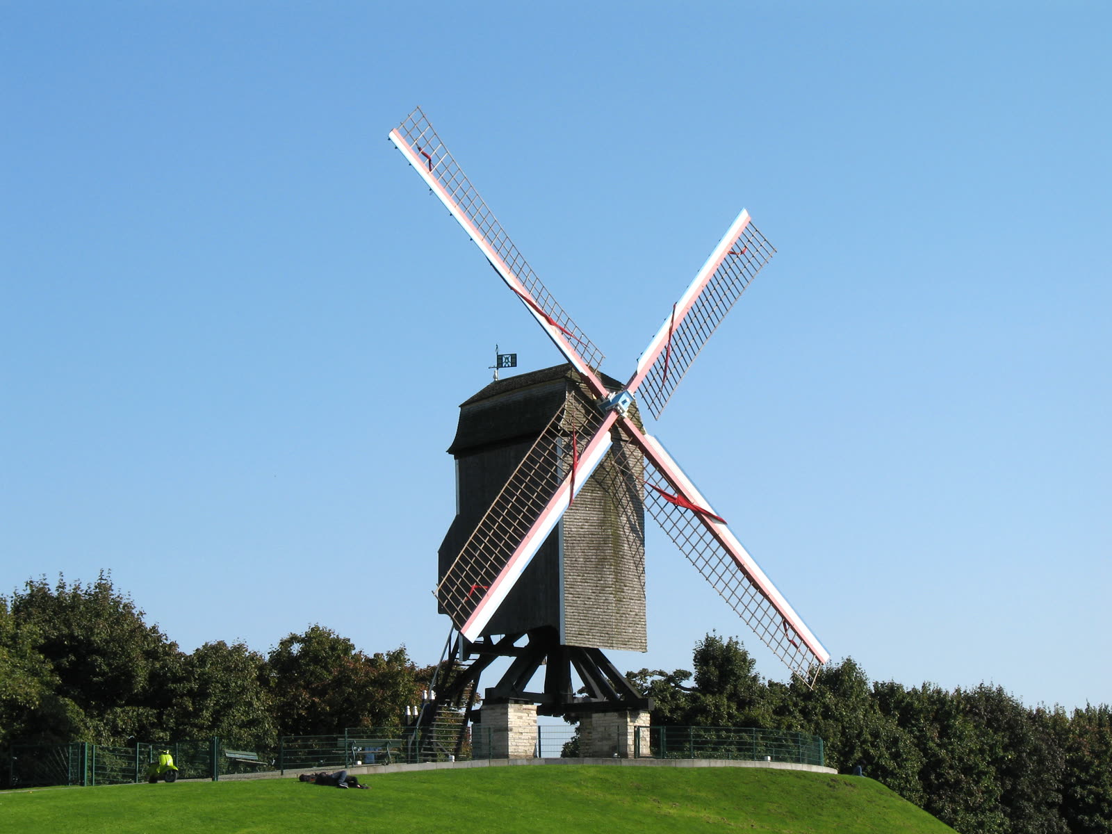
Image context: the cover uses a real documentary photograph of Sint-Janshuismolen from Wikimedia Commons. That is the right image for this article because the route is built around one exact Bruges correction: leave the center's compressed facades behind and use the eastern ramparts to read the city through wind, grass, and a still-working mill.[8]
Why the east edge reads Bruges better than another canal loop
The usual first-visit mistake is to assume that Bruges reveals itself by moving deeper into the center. In practice, the center often gives you less with each additional minute once the first spell has landed. The east edge reverses that law. At Kruispoort, the city is still legibly enclosed. One minute later, the wall becomes a linear park and the skyline gets room around it.[1][4]
The windmills matter because they keep heritage from becoming purely civic scenery. Visit Bruges says the mills once formed part of a much denser landscape, with as many as thirty mills counted by the 16th century before steam gradually replaced them.[2] Sint-Janshuismolen is the holdout that still works: an authentic Bruges post mill from the 18th century, still turning to meet the wind and still grinding grain.[3] If you want one paid interior stop, the official page currently lists adult admission at EUR5.[3] That optional detail changes the route's feel. The line of mills is not merely picturesque residue. It still contains one working object inside the city's memory.
The local-use signal also points east rather than inward. The same Bruges crowd-planning guide explicitly sends visitors to the windmills and city-gate circuit once the center gets clogged, noting that the walk out and back takes about 40 minutes and feels like a different city in peak season.[5] A quieter-corners guide describes Sint-Janshuismolen as the point where Bruges starts feeling less like a preserved medieval center and more like a lived landscape of wind, water, and labor.[6] That matters especially here, where the Vesten includes a protected cycling path and where the temptation is to drift sideways for photographs.[4]
Why this route is stronger at the shoulder than at peak crowd hours
Kruisvest is not a hidden secret, but it behaves differently from the Markt economy of attention. Bruges E-pass maps the crowd problem tightly: the busiest core window runs from around 10 a.m. to 5 p.m. in the Markt-Burg-Rozenhoedkaai cluster, while the windmill route rarely feels crowded at any hour.[5] Gamintraveler's late-2024 Bruges mistakes guide points visitors toward Kruispoort and the Sint-Anna side for exactly the same reason: the city gets calmer fast once you move beyond the main squares.[7] That is the right scale and the right expectation. This is not an empty Bruges. It is a Bruges where people thin out enough for proportion to return.
The best window is therefore the morning shoulder or the late-afternoon shoulder, when the ramparts still carry light but the center no longer dictates your pace. Early light makes the grass and water feel wider; later light makes the mill silhouettes cleaner and keeps the center's crowd from following you outward with the same density.[4][5][7] Midday still works, but it turns the route into scenery instead of atmosphere.
8 local moves that make this Bruges microcosm land properly
- Begin at Kruispoort, not at the Belfry. The whole point is to switch the city's grammar from square-and-canal compression to gate-and-rampart space.[1][4]
- Keep the first pause short. Read the gate's towers and passage, then move on before the route becomes a static history stop.[1]
- Walk the windmill line in sequence instead of photographing only the first mill and turning back. The eastern edge works because it stretches out, not because it offers one isolated postcard.[2][4]
- Treat Sint-Janshuismolen as the anchor if you want one paid interior. It is the authentic working Bruges mill on the line, and adult entry is currently EUR5.[3]
- Do this on foot. Recent Bruges guidance is consistent that the center is compact, most major sights are within about 15 minutes on foot, and the city rewards walking sequences better than forced bike efficiency.[5][7]
- If you want a cleaner continuation, keep north or west along the ramparts instead of snapping straight back to Markt. The windmill circuit works because it changes your pace for roughly 40 minutes, not because it gives one fast photo payoff.[5]
- Stay aware of the cycling line even when the place feels tranquil. The Vesten is not dead green space; it still carries movement through a protected cycle path.[4]
- Use shoulder hours. The east edge is strongest when the center is inside its 10 a.m. to 5 p.m. congestion band and this side remains looser by comparison.[5][7]
Non-local trapline: 4 common mistakes and the better alternative
Mistake 1: spending all your Bruges time inside the classic center because that feels like the "real" city
Better move: use Kruispoort and the ramparts to recover Bruges as a walled city with working edges, not just a core of saturated viewpoints.[1][4]
Mistake 2: treating the windmills as one quick photo stop
Better move: walk the full eastern line. The route needs gate, grass, and all four mill positions to change your sense of scale.[2][4]
Mistake 3: renting a bike for a micro-route that is better walked
Better move: keep this section on foot. Recent Bruges guides agree that the center is compact and that the rampart experience depends on pace more than speed.[5][7]
Mistake 4: wandering carelessly into lanes and cycle space because the city feels storybook-safe
Better move: keep spatial discipline. The Vesten includes a protected cycling line, and the route works better when you stop for photographs without spilling across the path.[4]
Concrete go details
- Best window: weekday morning or late afternoon, or even the midday core if your goal is specifically to escape the center's roughly 10 a.m. to 5 p.m. congestion band.[4][5][7]
- Expected spend: EUR0 if you keep the route outdoors; EUR5 if you add Sint-Janshuismolen as the one paid stop.[3]
- Queue or reservation reality: none for the walk itself. The only possible hold-up is whether you choose to enter the mill while it is open to visitors.[3]
- Where to stand: first just beyond the narrow passage of Kruispoort, then on the grassed edge beside Sint-Janshuismolen, where Bruges reads outward instead of inward.[1][3][4]
- Navigation cue:
Kruispoort -> Kruisvest ramparts -> windmill line -> Sint-Janshuismolen -> continue north or west along the green edge before re-entering the center.[1][2][5] - Numeric anchors worth keeping: 1297-1304, 1366, 1382, 1400, 4 mills, 30 mills by the 16th century, 18th century, 26 hectares, 3,000 trees, 7 km, EUR5, 15 minutes, 40 minutes, 10 a.m. to 5 p.m..[1][2][3][4][5][7]
Bruges does not always need a new attraction. Sometimes it only needs a new line of movement. One old gate, one green wall, four mills, and one working survivor are enough to turn the city from souvenir density back into place.
Sources
- Visit Bruges, "Kruispoort (Cross Gate)" (official page covering the gate's 1297-1304 construction, 1366 replacement, 1382 destruction, 1400 reconstruction, and its later ceremonial/strategic entries into Bruges).
- Visit Bruges, "Koeleweimolen (Koelewei Mill)" (official page covering the late-13th-century rampart mill tradition, up to 30 mills by the 16th century, and the four-mill eastern line with Sint-Janshuis still grinding).
- Visit Bruges, "Sint-Janshuismolen (Sint-Janshuis Mill)" (official page covering the 18th-century working post mill and the current public-admission pricing).
- Visit Bruges, "De Vesten" (official page describing the city ramparts as 26 hectares of green with more than 3,000 trees and views across more than 7 km of ramparts).
- Bruges E-pass, "Bruges Without the Crowds: Early Start vs Late Start Itinerary" (recent Bruges trip-planning guide used here for the compact-on-foot reading, the 10 a.m. to 5 p.m. core crowd window, and the roughly 40-minute windmill-and-city-gate circuit along the northeast ramparts).
- By Food and Travel, "Quiet corners of Bruges: A different way to see the city" (recent quieter-corners guide used here for the Sint-Janshuismolen reading as the place where Bruges shifts from preserved center to living landscape).
- Gamintraveler, "10 Common Mistakes To Avoid In Bruges And How To Avoid Them" (published 25 November 2024; used here for the compact-and-walkable city reading and the advice to move beyond the main squares toward spots like Kruispoort and Sint-Anna).
- Wikimedia Commons, "File:Sint Janshuismolen R01.jpg" (documentary photographic source page for the lead image).