Bratislava is compact enough that visitors often try to keep the Danube as scenery: castle above, Old Town behind, river in front, photograph taken, next stop. The better local reading is more physical. Cross Most SNP on foot, keep the UFO tower as your orientation object rather than your whole plan, then use Janko Kral Park and the Petrzalka riverbank as the slow landing. This is not a skyline route. It is a street microcosm where Bratislava changes banks without changing scale too quickly.[1][3][4]
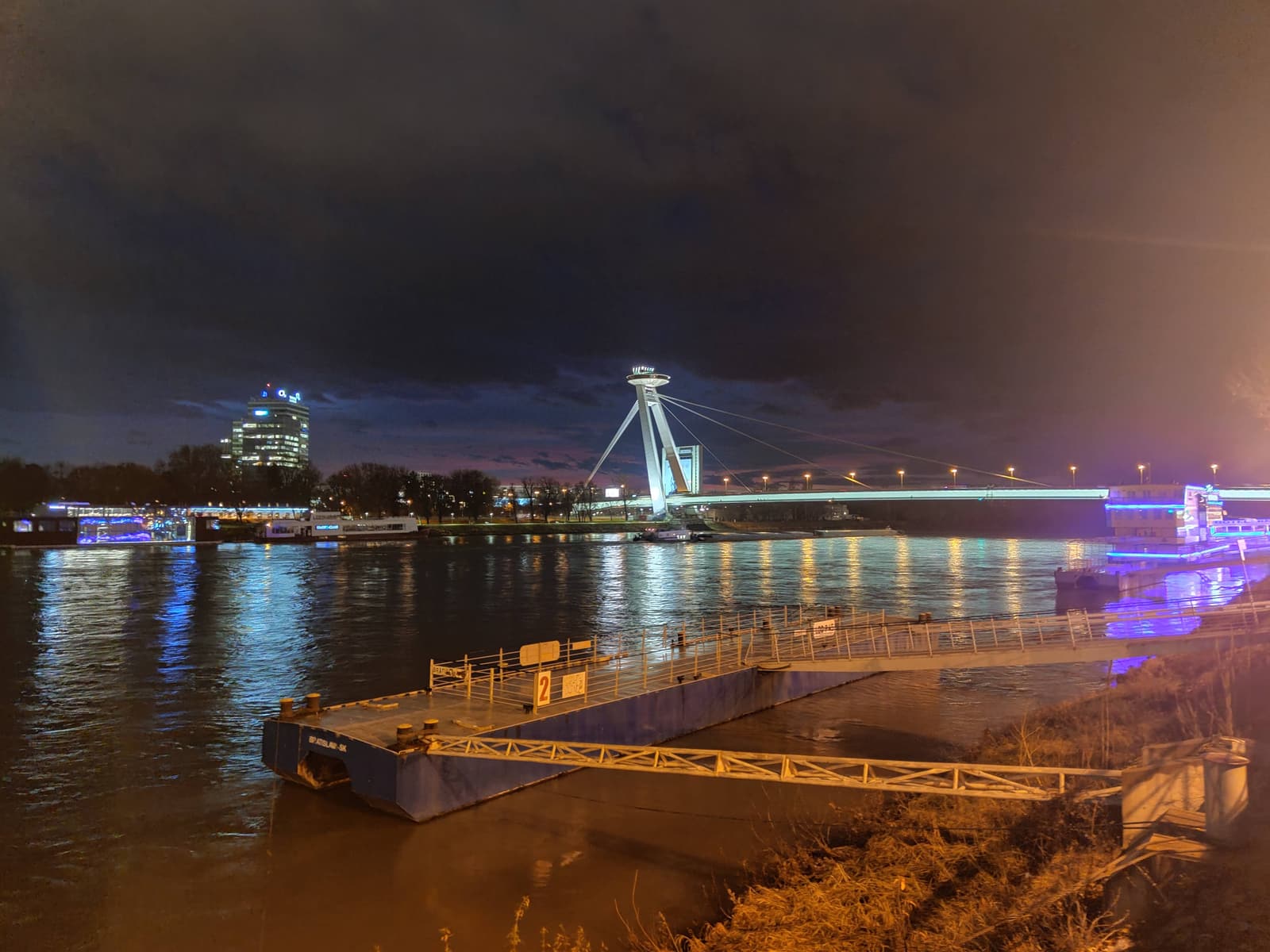
The bridge is the hard hinge. Visit Bratislava says Most SNP was built from 1967 to 1972, is 431.8 metres long and 21 metres wide, and carries a steel structure weighing 7,537 tonnes.[1] The UFO on the pylon is the obvious visual hook, but the more useful fact is spatial: the suspended bridge reaches over the Danube without supports standing in the middle of the river, so the crossing feels clean and exposed rather than interrupted.[1] That exposure is why walking it matters. A taxi erases the whole lesson.
The second anchor corrects the common visitor mistake. Janko Kral Park sits on the right bank, in Petrzalka, between the Old Bridge and the New Bridge, with 42 hectares of public green space and nonstop opening hours.[4] The city government describes it as the oldest public park in central Europe, protected as a historical green area, and explicitly ties it to the Tyrš Waterfront as part of everyday leisure for both Petrzalka and Old Town residents.[3] In other words, the opposite bank is not a blank afterthought. It is one of the easiest places to watch Bratislava behave like a city instead of a postcard.
Image context: the lead image is Rob Koster's 2022 Wikimedia Commons photograph of Most SNP. It is a real photographic view of the actual bridge discussed here, not a generated travel mood shot, map graphic, or diagram.[8]
The Crossing
Start from the Old Town side when you still have daylight, ideally in the late-afternoon shoulder. The UFO observation deck may be tempting, and it is a legitimate option: Visit Bratislava's English member page says the lift takes 45 seconds to a 95-metre observation point with sightlines up to 100 kilometres in good weather.[2] The Slovak visitor page gives the public hours as 10:00-23:00 for the observation deck and bar, with the restaurant opening 12:00-23:00.[2] Keep those numbers in your pocket, but do not let the paid view swallow the route.
The stronger first move is free. Walk the bridge and let the city rearrange itself under you. Behind you, the castle and Old Town compress into the left-bank postcard. Ahead, Petrzalka starts as concrete, traffic, paths, trees, and the large green block of Janko Kral Park. That is the point: Bratislava's beauty is not only the old center. It is the abrupt switch from historic slope to Danube crossing to everyday right-bank public space.[3][5]
Do not rush the descent. At the Petrzalka end, pause before choosing a direction. If you immediately turn the walk into a hunt for the UFO elevator, a cafe, or a shopping center, the route becomes another attraction list. Instead, orient by three objects: the bridge you just crossed, the park edge, and the riverfront path toward the Old Bridge. Recent local community advice still describes the bridge-to-park sequence as practical for short stays: cross the Danube through the UFO bridge, walk through Sad Janka Krala, then continue toward the Old Bridge or tram back if time is tight.[6]
Why The Park Landing Matters
Janko Kral Park is not just a patch of shade. Visit Bratislava traces the park's founding to 1774-76, says its present appearance has been preserved since 1839, and notes its circular zodiac spaces, old architecture, statue of Janko Kral, rare trees, and roughly 200-year-old maple-leaf plane trees with trunks over 500-600 centimetres in circumference.[4] That detail changes the walk. You are not simply escaping traffic. You are entering a public landscape older than most of the modern capital's visual shorthand.
The local reading of this bank is more mixed and more useful than a tourist brochure. In a r/Bratislava discussion about whether the riverbank opposite the castle is empty, one reply pushed back by naming the cultivated promenade between Most SNP and the Old Bridge, benches, leisure uses, anchored boats, memorial space, Tyršak activity, and the direct connection into Janko Kral Park.[5] The exact mix changes by season and event calendar, but the correction is stable: do not evaluate the right bank from across the water. Walk it.
Use the park as a deceleration device. After the bridge, give yourself 30 to 45 minutes on the Petrzalka side. That is enough for one slow park pass, a look back toward the UFO tower through trees, and a short riverbank section without turning the route into a forced loop. If you have less time, make it 20 minutes and keep the shape clean: bridge, park edge, river view, return. If you have more time, continue toward the Old Bridge rather than doubling back immediately.
Local Moves That Change The Outcome
First, cross on foot at least one way. The bridge's whole value is the exposed transition from Old Town to Petrzalka. Riding over it turns the route into trivia.[1]
Second, treat the UFO as a navigation object first and a paid viewpoint second. The observation deck is useful when weather is clear and you want the high read; it is not required for the route to work.[2]
Third, walk from the old center toward Petrzalka, not the reverse, on a first pass. That order makes the park feel like a discovery after the river rather than a prelude to the obvious historic core.
Fourth, do not stop at the bridgehead and declare the opposite bank empty. Local discussion keeps pointing out the promenade, leisure spaces, boats, and park connection between Most SNP and the Old Bridge.[5]
Fifth, use Janko Kral Park as the main pause, not the mall or the restaurant stack. The park is open nonstop, free, and old enough to carry the route without a purchase.[3][4]
Sixth, aim for late afternoon into early evening. You get workable light on the bridge, then softer park time, and the option of the UFO deck before or after sunset if the weather makes it worthwhile.[2]
Seventh, keep the route short. This is a 60-75 minute micro-route, not a full Petrzalka survey. The right bank rewards attention, but the first visit should stay legible.
Eighth, exit by a different line if energy allows. Continuing toward the Old Bridge gives the route a cleaner arc than returning immediately to the same bridge, and local advice supports the SNP-park-Old-Bridge logic for short city windows.[6]
Non-Local Trapline
Mistake 1: treating Most SNP as only a photo object. The better move is to cross it. The bridge is a piece of city infrastructure that teaches the left-bank/right-bank relationship in a few hundred metres.[1]
Mistake 2: making the UFO deck mandatory. The better move is conditional: go up if visibility, budget, and timing support it; otherwise let the pylon guide the free walk.[2]
Mistake 3: assuming Petrzalka begins with emptiness. The better move is to test that assumption on foot. The city page and local community discussion both describe a real leisure corridor tied to the park and waterfront.[3][5]
Mistake 4: turning the park into a shortcut. The better move is to slow down. Its 1774-76 origin, 42-hectare scale, old trees, and everyday meeting-point role are the payload, not background greenery.[4]
Concrete Go Details
Best time window: late afternoon through early evening, with enough daylight for the bridge crossing and enough dusk for the UFO silhouette to start working.[2][8]
Expected spend: EUR0 for the core route. Add the UFO observation deck only if you want the paid high view; the park and bridge walk carry the route without it.[2][3][4]
Queue/reservation reality: no reservation for the bridge or park. The only possible friction is the observation-deck lift, weather visibility, event crowding on the waterfront, and ordinary city traffic around the bridgeheads.[2][5][7]
Where to stand or sit: pause first on the Petrzalka side with the bridge behind you, then sit or slow down inside Janko Kral Park rather than hovering at the road edge.[3][4]
Navigation cue: Old Town side -> Most SNP pedestrian crossing -> UFO pylon as orientation -> Janko Kral Park -> Tyrš Waterfront / Old Bridge direction -> return by bridge, tram, or riverbank walk.[3][5][6][7]
Numeric anchors worth remembering: 1967-1972, 431.8 metres, 21 metres, 7,537 tonnes, 45 seconds, 95 metres, 1774-76, 42 hectares, and a 60-75 minute first-pass route.[1][2][4]
Bratislava does not need a grand Danube itinerary here. One suspended bridge, one unmistakable tower, one older public park, and one right-bank walk are enough to make the city less centered on its postcard face and more legible as a river city with two working sides.
Sources
- Visit Bratislava, "Bridge SNP" (official tourism page used for construction dates, bridge dimensions, weight, single-pylon suspension framing, and UFO restaurant/viewpoint context).
- Visit Bratislava, "UFO watch.taste.groove." (official/member pages used for the 45-second lift, 95-metre height, up-to-100-km sightline claim, address, and observation-deck/bar/restaurant hours).
- City of Bratislava, "Janko Kral Park and Tyrš Waterfront" (municipal page used for the park's protected historical-green-area status, central-European public-park claim, and everyday leisure role with the Tyrš Waterfront).
- Visit Bratislava, "Janko Kral Park" (official tourism page used for the 1774-76 founding, 1839 preserved appearance, 42 ha area, nonstop opening hours, park features, and old-tree details).
- Reddit / r/Bratislava, "Why is the riverbank opposite of the Castle so empty?" (local community thread used for ground-level context on the promenade, benches, leisure uses, anchored boats, Tyršak, and the park connection).
- Reddit / r/Slovakia, "What to visit in half day in Bratislava?" (recent local/community thread used for the short-stay route logic: castle/riverbank, crossing the UFO bridge, Sad Janka Krala, Old Bridge, and tram fallback).
- Google Maps search, "Most SNP Bratislava Sad Janka Krala" (current navigation and community-review surface for live route checks around the bridge, park, and riverbank).
- Wikimedia Commons, "File:Most SNP.jpg" (documentary photographic source for the cover image by Rob Koster, photographed January 4, 2022).