Asuncion is easiest to misread when you treat the center as a list of monuments and the riverfront as a separate exercise strip. The cleaner move is tighter: start with Palacio de Lopez as the lit anchor, step down toward the Costanera, hold the bay edge for a short dusk-to-night walk, and leave before the route turns into vague distance. This is a night room, not a full downtown survey.
The official visitor framing supports that small route. Pinta Asuncion describes Avenida Jose Asuncion Flores, better known as the Costanera, as both avenue and pedestrian street, initially inaugurated in 2012, with free and open access and views across Asuncion Bay toward the historic center: Cabildo, Congress, the Metropolitan Cathedral, and Palacio de Lopez.[1] The municipality's own maintenance note gives the other scale fact: the larger Costanera system it maintains runs from Palacio de Lopez toward the Botanical Corridor and reaches about 20 kilometers.[2] For a first evening, that number is a warning. Do not try to "do the Costanera." Use one civic bend of it well.
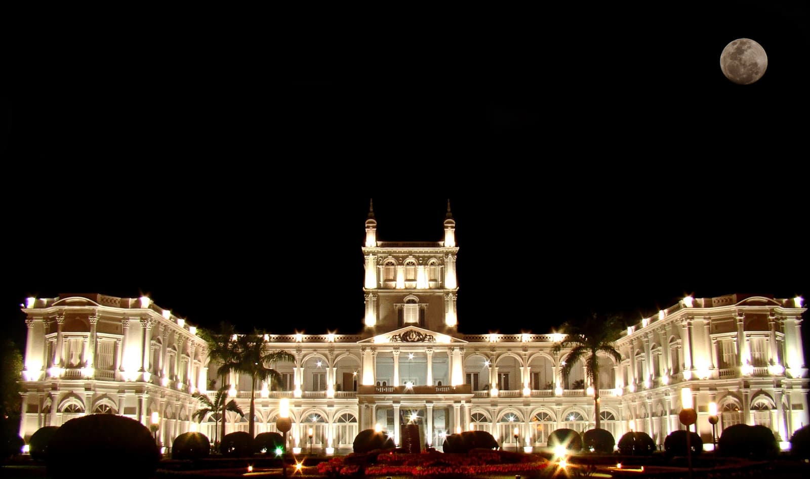
The palace is the reason the route works at night. The municipal heritage essay places the current Palacio de Lopez in a long line of Paraguayan government houses, notes that work on the palace began in 1857, and says the presidential government has been seated there since 1894.[4] It also identifies the building as Paraguayan heritage and a cultural treasure of Asuncion.[4] By day, that history can feel heavy. At night, the building becomes a precise orientation object: lit facade, bay air, wide road, and the old center just behind you.
Image context: the cover photograph is Marco Bogarin's Wikimedia Commons image of Palacio de Lopez illuminated at night. It is a real documentary photograph of the actual government palace discussed here, so it satisfies the route's recognition cue without using a diagram, generated image, or generic waterfront mood shot.[8]
The Short Route
Begin near the palace, not in the middle of the waterfront. That decision keeps the walk specific. The city's page for the Asuncion letter sculpture says the letters sit below the coastal facade of the Government Palace, where the Costanera begins, and were deliberately placed with the historic palace as their background.[3] That tells you how the room is supposed to read: civic building first, bay second, photo stop third.
Use the letters if the space is open and calm, but do not let them become the whole stop. They are useful because they mark the threshold where the old center loosens into the river edge. The stronger memory is the relationship: palace behind, open bay in front, traffic and pedestrians widening around you. If there is a small queue for photos, skip the front-on pose and keep the room intact.
Then walk the Costanera slowly for 30 to 45 minutes, not two hours. The official page's "free and open access" line matters because there is no ticket clock forcing a pace.[1] The local-use signal matters more. A recent r/Paraguay thread about what to do in Asuncion names weekday cultural sites in the center, Palacio de Lopez and Congress tours, and weekend activities by associations on Avenida Costanera.[5] That is the useful clue: the waterfront is not just an attraction. It is where public activity spills when the center needs air.
Keep the bay on one side and the palace in your mental rearview. If you keep walking after both become abstract, you have gone too far for this version. The Costanera can carry running, cycling, family strolling, event spillover, and long-distance exercise; your route is narrower. You are borrowing one evening room from a much longer public edge.
Local Moves That Change The Outcome
First, arrive in the shoulder between last light and full darkness. The palace illumination needs night, but the bay edge is easier to read while some sky remains. If you arrive too early, the walk feels like ordinary heat and traffic. If you arrive too late, you lose the spatial handoff from historic center to river.
Second, approach by a named street, not by "the waterfront" as a map abstraction. In a local r/Paraguay route thread, one commenter reduces the walk from Lido Bar toward Palacio de Lopez and the Costanera to a practical line: use El Paraguayo Independiente toward the palace, then continue to the bay-side access, with police presence around the safer route.[6] Current map pins are useful only after that route decision is made; use them to confirm the Costanera pickup or walking point, not to improvise a shortcut through the wrong edge.[7] The exact path can vary with construction and event closures, but the principle holds. Pick a clear city-center spine, stay on it, and avoid improvising through side streets you have not read.
Third, make the palace your safety and orientation anchor. This is not a claim that nothing can go wrong; it is a practical visitor rule. The local route thread exists because people ask how to avoid the wrong edges around Chacarita when walking to the Costanera.[6] Do not romanticize that uncertainty. Use the obvious civic corridor, keep your phone handling discreet, and use a rideshare for the return if the street rhythm feels thin.
Fourth, keep the spending baseline at 0 guaranies. The best version costs nothing because the value is public space: palace light, bay width, pedestrian movement, and the feeling of Asuncion opening toward water.[1][3] Food or drinks can come later in the center, but if dinner becomes the anchor, this stop loses its clarity.
Fifth, sit or stand where you can see both movement and distance. The Costanera works best when you are not pressed against the most obvious photo point. Give runners, cyclists, families, and photo groups the front lane. Step slightly back, let the palace sit in profile, and watch how the bay edge gathers people without making them buy anything.
Sixth, treat weekend energy as optional, not mandatory. The recent local thread points to weekend activities on Avenida Costanera, but that does not mean a visitor should chase the busiest hour.[5] If the goal is a night room, a calmer weekday can be better. If the goal is local public life, weekends give more texture but also more traffic and photo compression.
Seventh, finish cleanly. Once the palace has become background and the bay no longer feels like a threshold, leave. A night room has an exit. Either return toward the palace and old-center streets you understand, or call transport from a well-lit, obvious pickup point.
Non-Local Trapline
Mistake 1: trying to walk the whole Costanera because the number sounds impressive. The better move is one palace-to-bay segment. The municipal 20-kilometer maintenance scale proves the waterfront is a system, not a first-night assignment.[2]
Mistake 2: treating the Asuncion letters as the destination. The better move is to use them as a threshold marker. The municipality placed them with the Palacio de Lopez facade as the intended backdrop, so the broader composition matters more than the sign itself.[3]
Mistake 3: drifting through side streets because the river looks close on the map. The better move is a named, visible approach toward Palacio de Lopez, then a simple drop to the Costanera. Local discussion around walking there is explicit about route choice and perceived safety around the nearby edges.[6]
Mistake 4: making this a late-night endurance walk. The better move is dusk into early night, then a controlled exit. The Costanera may be public and open, but visitors still need ordinary city judgment about light, crowds, and transport.[1][6]
Concrete Go Details
Best window: 30-60 minutes before sunset through about 30 minutes after full dark, depending on heat, weather, and whether you want quiet civic scale or weekend activity.
Route shape: Palacio de Lopez area -> Asuncion letters / bay-facing threshold -> short Costanera walk -> return to palace side or leave from a well-lit pickup point.[1][3][6]
Expected spend: 0 guaranies for the public-space route; add transport money if you do not want to walk back through the center after dark.[1][6]
Queue/reservation reality: no reservation and no entry queue for the walk. The only friction is event crowding, photo clustering at the letters, and the common visitor problem of choosing the wrong approach street.[3][5][6]
Navigation cue: keep Palacio de Lopez visible or recently behind you. If the palace has disappeared from the route's logic, you are probably doing the long Costanera rather than this night room.
The point is not that Asuncion suddenly becomes polished at night. It is that one short waterfront room lets the city show its working parts without turning them into a scavenger hunt: government palace, bay edge, public promenade, weekend activity, and the old center's complicated threshold all in one controlled walk.
Sources
- Pinta Asuncion, "The Costanera" (visitor page used for the 2012 inauguration note, free/open access, and views of Asuncion Bay, Cabildo, Congress, Cathedral, and Palacio de Lopez).
- Municipalidad de Asuncion, "Varios trabajos de mejoras se realizaron en la Costanera de Asuncion" (municipal note used for the Palacio-to-Botanical-Corridor maintenance frame, approximate 20 km scale, and recreational public-space role).
- Municipalidad de Asuncion, "Conjunto Escultorico con la palabra 'Asuncion' fue inaugurado en la Costanera" (municipal note used for the letter-sculpture location below the Palacio de Gobierno coastal facade and its intended palace backdrop).
- Municipalidad de Asuncion, "El Palacio de Lopez es el mayor tesoro de los bienes patrimoniales de Asuncion" (municipal heritage essay used for the 1857 construction start, 1894 government occupancy, and heritage status).
- Reddit / r/Paraguay, "Que hay para hacer en Asuncion" (recent local/community thread used for current visitor advice naming Palacio/Congress tours and weekend association activity on Avenida Costanera).
- Reddit / r/Paraguay, "Playa de La Costanera" (local/community route thread used for approach-street advice from the center toward Palacio de Lopez and Costanera, plus safety-aware navigation cues).
- Google Maps search, "Costanera de Asuncion" (current community-review and navigation surface for the waterfront corridor).
- Wikimedia Commons, "File:Palacio de Lopez de noche.jpg" (real night photograph by Marco Bogarin used as the cover image source).