Bogota's Ciclovia is easy to misunderstand if you treat it as a bike lane. The better ritual is narrower and more useful: start early on Carrera Septima, use the stretch around Parque Nacional, Calle 26, and the downtown edge as a Sunday civic room, and leave before the 2 p.m. reset returns the avenue to ordinary traffic.[1][3][6]
That timing matters because Ciclovia is not a casual closure. Portal Bogota's April 2026 update says the city now reaches 141.46 kilometers of enabled Ciclovia after a new Suba segment, with the free Sunday and holiday service running 7:00 a.m. to 2:00 p.m. under IDRD operation.[1] IDRD's history page gives the older reason Carrera Septima feels like the spine of the ritual: the city formally created Ciclovia in 1976, one early circuit linked Parque Nacional with the funicular area, and by 1982 an official space ran on Kr. 7 from Calle 32 to Calle 72.[2]
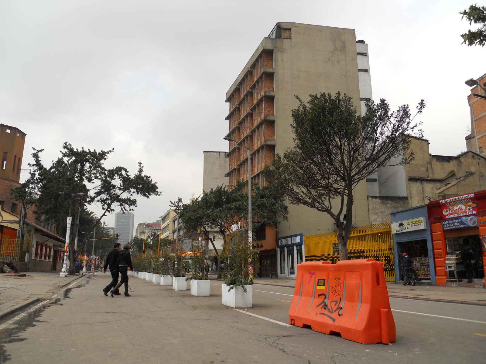
So the route is not "rent a bike, see attractions." The route is "enter the city while it has temporarily changed rules." The cover photograph, taken at Carrera Septima with Avenida Calle 26, shows the actual texture: people on foot and bicycle sharing a broad, recognizable central avenue, with enough street width to make Bogota feel briefly less defensive.[7] That is the anchor. One street, one operating window, one local rhythm.
Start while the city is still stretching
The strongest entry is between 7:30 and 9:00 a.m. By then the route is awake, but the densest family and tourist wave has not fully arrived. If you begin near Parque Nacional or the Calle 26 crossing, you get the central-city version without having to solve the entire 141-kilometer network.[1][6] The point is not distance. It is letting the avenue teach you how Bogotanos use a street when engines are removed.
The current official surface is large, and that scale can tempt visitors into overplanning. IDRD reported 2,426,363 participations on the fourth Sunday of 2026, including 1,720,646 bicycle participations and 651,114 walking participations.[4] Those numbers explain why the first local move is modest: choose a short central segment and watch the flow before deciding whether to continue north or south. Ciclovia works because it is shared by fast riders, strollers, runners, skaters, dogs, vendors, and people who are just reclaiming a Sunday morning. A visitor who charges through it like a training ride misses the civic part.
The route-specific clue is that IDRD still programs services and activities on this corridor, not only on the outer segments. Its March 26, 2026 Semana Santa notice placed mobility-safety campaigns around Carrera 7 with Calle 34 and Carrera 7 with Calle 28, and even used the Calle 28 point for Canal Capital's Cicloviva coverage.[3] That is a practical signal: the central stretch is not ornamental. It remains staffed, visible, and part of the official Sunday choreography.
Let Carrera Septima be the room
Use the first 20 minutes without ambition. Walk or roll north-south on Carrera Septima until the street pattern settles: faster bicycles drift toward the open line, walkers cluster by crossings, vendors collect near pauses, and families move in soft groups rather than straight lanes. The important local behavior is spatial politeness. Keep predictable, do not stop suddenly in the moving line, and use the curb edge or a plaza opening when you want to look around.
Local community advice points toward the same small circuit. In a r/Bogota thread about where people go when they leave the house, one user describes a Sunday routine of walking Ciclovia down La Septima to the flea market around Calle 22, returning toward Parque Nacional, then folding in an ordinary snack stop.[5] Another comment starts from a TransMilenio stop near La Mariposa and moves through Jimenez, electronics stores, books, and central streets.[5] The lesson is not to copy either itinerary exactly. It is that locals often use the corridor as a loose urban hinge, not as a single attraction with a finish line.
That is why the best visitor version stays compact. From Parque Nacional, drift toward Calle 26, then decide whether Calle 22 and the downtown edge feel right that day. If the crowd feels heavy, hold the Parque Nacional-Calle 26 portion and stop. If the street feels open and you are comfortable with central Bogota, extend slowly. The Google Maps layer is useful here because place status, crossings, and return transit points matter more than abstract route ambition.[6]
8 local moves that keep the ritual clean
- Start before 9:00 a.m. The official window runs 7:00 a.m.-2:00 p.m., but the morning half carries the better local rhythm.[1]
- Pick Carrera Septima as the anchor, not the whole city map. The citywide system is now 141.46 kilometers; the useful visitor route is a short central reading of it.[1]
- Use Parque Nacional or Calle 26 as the first orientation point. They give you the historic Ciclovia axis without dropping you cold into the deepest downtown crowd.[2][7]
- Walk for 20 minutes before deciding whether to rent, ride, or continue. The flow tells you more than a route map does.[4][6]
- Stay predictable in the moving lane. Sudden photo stops belong on the side, not in the bicycle line.[3][4]
- Treat IDRD staff and programmed points as route information. Campaigns and activity nodes around Calle 28 and Calle 34 show where the city expects Sunday users to collect.[3]
- Build a return plan before noon. The 2 p.m. end sounds far away at breakfast and very close once traffic logic starts returning.[1][3]
- Keep valuables boring. The route is public, busy, and staffed, yet central Bogota still rewards low-drama pockets, zipped bags, and phone checks from the edge rather than the flow.[3][5][6]
Non-local trapline: 4 common misses
Mistake 1: treating Ciclovia as a cycling workout
Better move: use the first central segment as a social reading. Walkers are not in the way; they are part of the system. IDRD's January participation report counted hundreds of thousands of walking participations alongside bicycles.[4]
Mistake 2: beginning too late
Better move: start in the 7:30-9:00 a.m. band and leave yourself a noon exit. The service ends at 2:00 p.m., and the best texture sits before the street starts feeling like it is preparing to become traffic again.[1]
Mistake 3: chasing the full network
Better move: let the 141.46-kilometer scale impress you without trying to consume it. The central ritual is stronger when it stays to one readable anchor.[1][2]
Mistake 4: leaving the active corridor for "more local" side streets without a plan
Better move: use local pauses, crossings, parks, and mapped transit returns. The r/Bogota thread shows locals improvising around La Septima and nearby streets, but they are doing so with neighborhood familiarity.[5][6]
Concrete go details
- Best window: 7:30-10:30 a.m. on a Sunday or holiday, with a hard mental cutoff before 2:00 p.m.[1]
- Expected spend: COP 0 for the street itself; budget separately only if you rent a bike, buy water, or stop for food after the route.[1]
- Queue and crowd reality: there is no reservation layer, but the route is mass-scale; January 2026's biggest reported Sunday reached 2.4 million-plus participations citywide.[4]
- Where to stand or sit: step to the side at Calle 26 or near Parque Nacional when you want to watch, photograph, or check the map; keep the central moving line clear.[3][6][7]
- Navigation cue:
Parque Nacional / Carrera Septima -> Calle 34 / Calle 28 activity band -> Calle 26 recognition point -> optional Calle 22 downtown edge -> return before noon.[2][3][5][7] - Recent confirmation: the latest official city update used for this article is April 14, 2026, adding 3.22 kilometers and taking Ciclovia to 141.46 kilometers from April 19.[1]
Bogota's Sunday morning does not need a bigger itinerary here. It needs the discipline to enter one street at the right hour, move like the street is shared, and leave while the temporary city is still intact.
Sources
- Portal Bogota, "Ciclovia de Bogota sigue creciendo: alcanzo 141,46 kilometros por nuevo tramo en la localidad de Suba" (official April 14, 2026 city update on the 141.46-kilometer network, 7:00 a.m.-2:00 p.m. Sunday/holiday operation, and the Suba addition).
- IDRD, "Ciclovia de Bogota: 50 anos de Movilidad Sostenible y Recreacion" (official history page covering the 1976 formal creation, early Parque Nacional-Funicular circuit, and Carrera 7 official space).
- IDRD, "La Ciclovia de Bogota tendra operacion especial y amplia agenda de actividades durante Semana Santa" (March 26, 2026 official operations update with Carrera 7 activity and safety-campaign points).
- IDRD, "Bogota registra la Ciclovia con mayor afluencia del ano" (January 25, 2026 official participation report with bicycles, walking, and total participation counts).
- Reddit / r/Bogota, "Cuando salen a donde van?" (local community thread on Sunday La Septima walking habits, Parque Nacional return logic, and central-city wandering).
- Google Maps search, "Ciclovia Carrera Septima Parque Nacional Bogota" (current community-review and navigation surface for crossings, place status, and return-transit checks; accessed April 21, 2026).
- Wikimedia Commons, "File:Ciclovia en el centro de Bogota.jpg" (documentary photograph used for the cover image; depicts Ciclovia on Carrera Septima at Avenida Calle 26).