If you only borrow one Bergen move from locals, make it this: do not let Fløibanen collapse into a summit-only attraction.
The cleaner version is smaller and more specific. Ride up only as far as Fjellveien, step off where the line starts behaving like hillside transport instead of tourist climax, and walk the horizontal seam back toward Skansen while the city is still damp, reflective, and readable.[1][2][4][6] Bergen is full of viewpoints. What is harder to find is a route where the mountain and the neighborhood are still stitched together. This one keeps that stitch visible.
That is also why this works best after a shower has just cleared or before the late-day crush hardens. The official Fløibanen pages make two useful facts plain. First, the line is operationally busy in a very specific way: the heaviest period is 10:00-14:00, with waits of about 15-20 minutes.[1] Second, the intermediate stations follow their own timetable logic rather than the summit's. In the normal pattern, intermediate stops are served every full and half hour; from June 15 to August 31, between 09:00 and 15:00, they drop to every full hour only.[1][2] That means the Fjellveien version rewards timing and punishes default behavior.
The official history and FAQ pages help explain why this seam feels more local than the usual top-and-back run. Fløibanen opened in 1918, rises to 320 meters above sea level, and still functions as normal transport for people living on the mountainside and for kindergartens on Fløyen; the full ride takes only 4-8 minutes, and each carriage can hold up to 120 passengers.[2] That transport role matters. Once you stop treating the line as a single scenic event and start reading it as a working piece of hillside infrastructure, the intermediate stations stop looking like trivia.
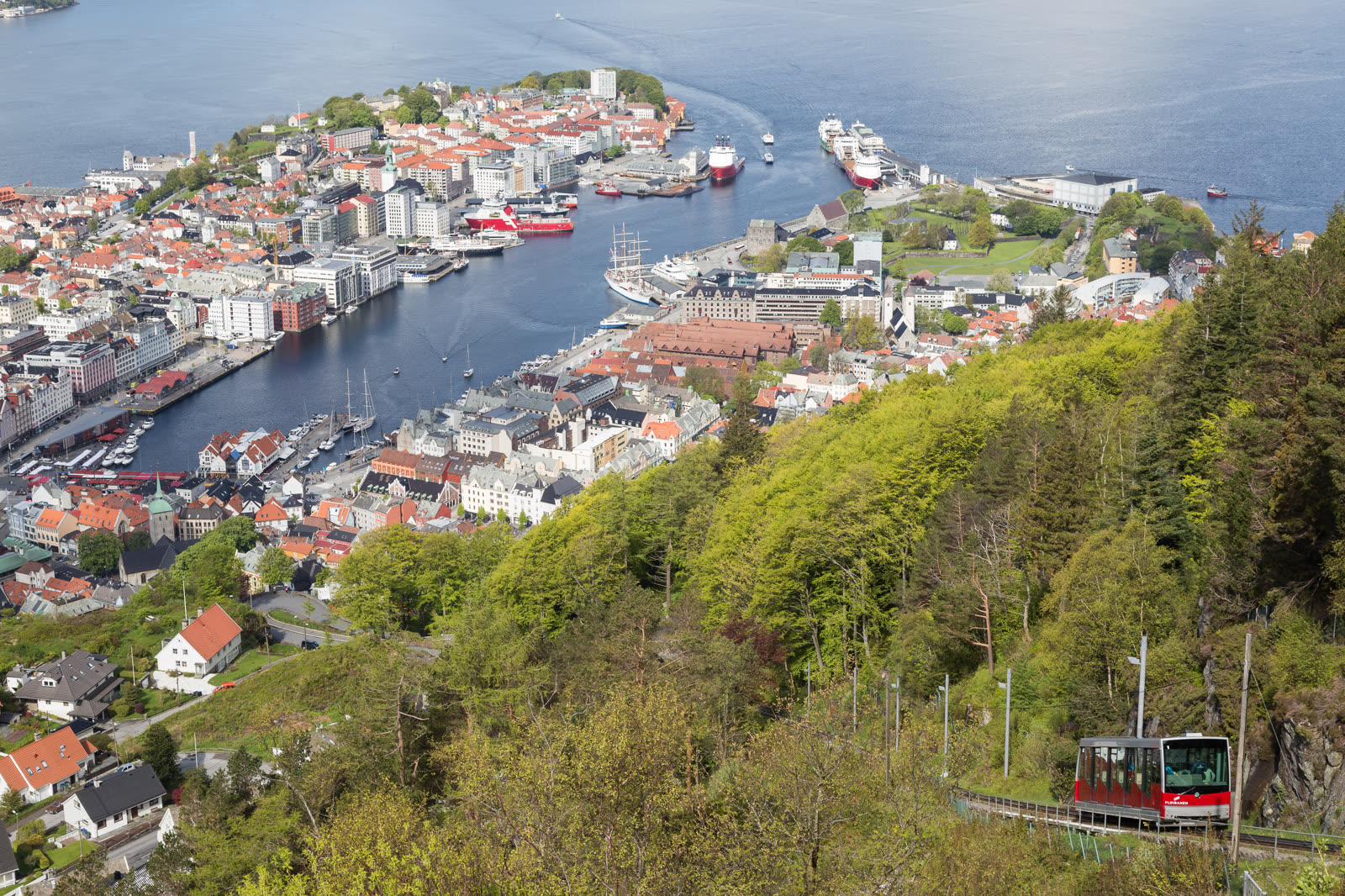
Image note: the cover is a real documentary photograph of Fløibanen above Bergen, chosen because this route depends on seeing the line in its actual urban setting rather than as an abstract "viewpoint ride."[9]
Why the Fjellveien cut works better than the summit-default version
The bottom station is only about 5 minutes on foot from the Fish Market and roughly 15-20 minutes from the cruise terminal.[2][3] That convenience is exactly what pushes many visitors into the same mistake: they board, go all the way to the top, absorb the expected panorama, then either queue again or walk down on autopilot. The result is scenic but blunt.
The Fjellveien cut has a different rhythm. Visit Bergen's own Fløyen page points out that Fjellveien is where the two funicular cars pass each other, and suggests taking the line to that stop if you want to walk from there.[6] That detail sounds small, but it changes the whole route. Fjellveien is not the spectacular conclusion of the mountain. It is the point where Bergen's roofs, retaining walls, slope streets, and transit technology become one readable unit.
From there, the official walking guide gives you the next layer: the road behind the lower station runs past Skansedammen and up to Fjellveien; from the Fjellveien stop, Fløysvingene begins about 200 meters north by the drinking fountain, while the Skansemyren option stays paved and keeps broad southward views.[4] You do not need to take either of those climbs for this article's version. It is enough to understand that this stretch is a decision seam, not only a transit stop.
The local/community material pushes in the same direction. Recent Bergen advice on Reddit still describes the path behind the lower station as the natural way toward Skansen fire station, and locals explicitly mention using the intermediate stations to save money or to start a run higher up the slope.[7] Another current Bergen thread frames Fløien as walkable or rideable, while naming Stoltzen/Stoltzekleiven as the hard, local-feeling stair option that starts off Fjellveien.[8] Together with the official Stoltzekleiven page, which fixes the start at Fjellveien 13 and about 908 steps, you get a clear picture: this is a lived mountain edge, not a sealed attraction zone.[5][8]
The sequence that changes the outcome
Start at the lower Fløibanen station, but do not arrive with summit energy. Arrive with transfer energy.
That means buying ahead if you can, avoiding the 10:00-14:00 crush, and boarding with one purpose: get to Fjellveien, then get off.[1][3] In the April-to-September pricing window, Visit Bergen lists one-way adult pricing in the NOK105-120 range depending on purchase channel, which is useful because this route needs only a partial ride, not a round-trip attraction ticket.[3]
Once you step out at Fjellveien, walk slightly back uphill for the pass point if you want the cleanest read of the cars crossing, then let the route flatten into a neighborhood edge.[6] The payoff is not one single overlook. It is the alternation: wet roofs, stair cuts, side streets dropping away, the sense that Bergen is stacked rather than spread.
Keep moving toward Skansen instead of turning the stop into a static photo chore. The community path language about the road behind the station leading toward Skansen fire station is useful here because it reminds you that this whole seam is navigated as part of ordinary movement, not only sightseeing.[7] You are effectively walking across the hinge where the city stops climbing straight up and starts running sideways along the mountain.
This is also why the route improves in broken weather. After rain, the timber facades and roof planes regain contrast, and the harbor-city cliché drops away. Bergen reads better when it looks recently washed. The Fjellveien seam gives you enough altitude to register that change without lifting you so high that the city becomes only a postcard.
8 local moves that make this Bergen seam actually work
- Treat Fløibanen as hillside transport first. The fact that locals and kindergartens use it is not background color; it tells you how to ride it.[2]
- Aim outside 10:00-14:00. That is the official congestion band, and it is the easiest way to turn a precise route into a queue story.[1]
- Check the intermediate-stop pattern before you go. Normally it is every full and half hour, but from June 15 to August 31, 09:00-15:00, it shifts to full hours only.[1][2]
- Get off at Fjellveien on purpose, not because you missed the summit. This stop is the route's center of gravity.[4][6]
- Walk slightly back uphill for the passing point. Visit Bergen highlights Fjellveien as the place where the two cars meet, and that crossing is one of the clearest visual explanations of the route.[6]
- Keep the walk horizontal longer than instinct suggests. The point is not to re-climb immediately; it is to let the mountain edge behave like a street.
- Use Stoltzekleiven only as a boundary marker unless you actually want effort. Its official start at Fjellveien 13 and about 908 steps makes it a great reference point, but not a mandatory add-on.[5]
- Let Skansedammen or Skansen end the route cleanly. Finishing with one calm civic edge works better than trying to absorb all of Fløyen in one outing.[4][7]
Non-local trapline: 3 common mistakes and the cleaner alternative
Mistake 1: riding all the way to the top because that is what the map seems to imply
Better move: use the intermediate stop deliberately. Bergen's official and local material both make clear that Fjellveien is not an afterthought.[1][4][6][7]
Mistake 2: arriving at midday and then blaming Bergen for the wait
Better move: respect the official 10:00-14:00 pressure band and shift earlier or later. This route is operationally sensitive in a way a flat city promenade is not.[1]
Mistake 3: turning Fjellveien into a staircase challenge by default
Better move: keep the route lateral. Stoltzekleiven is there if you want 908 steps of effort, but the street microcosm version depends on restraint, not conquest.[5][8]
Concrete go details
- Best time window: early morning, late afternoon, or immediately after rain clears; avoid the official 10:00-14:00 busy period.[1]
- Ride logic: use a one-way trip to Fjellveien rather than a full return pattern; in the current Visit Bergen pricing surface, one-way adult tickets sit around NOK105-120 in the spring-summer window depending on how you buy.[3]
- Timing anchors worth keeping in your head: 1918, 320 m, 4-8 minutes, 10:00-14:00, 15-20 minutes, 15 June, 31 August, 09:00, 15:00, 200 meters, 908 steps.[1][2][4][5]
- Access cue: the lower station sits about 5 minutes from the Fish Market and about 15-20 minutes from the cruise terminal, so you can fit this route into a short city window without a bus.[2][3]
- Walking cue: from the lower station, the official uphill path runs past Skansedammen toward Fjellveien; if you continue toward Skansen, you keep the city's slope logic visible rather than dropping immediately back into the center.[4][7]
- Exit options: stop cleanly at Skansen, or if energy is high, use Fjellveien 13 as the threshold for deciding whether today's version becomes a Stoltzekleiven climb.[5]
Bergen's obvious move is to go upward until the city turns into panorama. The better small move is to stop midway, let the line and the hillside keep speaking to each other, and walk the seam while the rain has just left. That is where Bergen stops performing and starts behaving like itself.
Sources
- Fløyen, "Opening hours" (official Fløibanen timetable, peak-hour wait guidance, and intermediate-station schedule rules).
- Fløyen, "FAQ" (official history, 1918 opening, 320-meter summit, 4-8 minute ride, 120-passenger capacity, and lower-station access guidance).
- Visit Bergen, "Fløibanen funicular" (official destination page with lower-station location, ride timing, and 2026 ticket-pricing surface).
- Visit Bergen, "Walking up or down Mount Fløyen" (official route guidance past Skansedammen to Fjellveien, plus Fløysvingene and Skansemyren decision points).
- Visit Bergen, "Stoltzekleiven" (official start point at Fjellveien 13, approximate 908 steps, and onward relation to Fløyen).
- Visit Bergen, "Fløyen" (official note that the two funicular cars pass at Fjellveien and that you can start walking from that stop).
- Reddit, r/NorwayTravelAdvice, "Runner visiting Bergen: can I run from downtown to the mountains?" (recent local/community advice on the path behind the lower station, Skansen fire station, and using intermediate stations).
- Reddit, r/Bergen, "What to do/see in Bergen?" (recent local/community framing of Fløien, walk-up timing, and Stoltzekleiven starting from Fjellveien).
- Wikimedia Commons, "File:Fløibanen.jpg" (archival photographic source for the cover image showing the funicular above Bergen).