Belgrade's center is good at absorbing first-timers. Knez Mihailova, Kalemegdan, Skadarlija, the fortress edge, and the new waterfront can fill a day before the city has actually changed register. The cleaner correction is to cross into Zemun without treating it as a side trip. Use Gardoš hill as the first anchor and Kej Oslobođenja, the Danube quay below it, as the second. The route works because it turns Belgrade from a capital-center itinerary into a border-town walk: brick, loess, low streets, river air, and a tower built for a political geography that no longer exists.[1][2][3]
Zemun has the useful oddness of being inside Belgrade and not quite mentally inside Belgrade. Serbia's national tourism Danube guide frames it as a former lively town on the Austrian-Turkish border, where border guards, spies, insurgents, confectioners, educators, and gardeners once crossed paths on the main street.[1] The official heritage file for the old downtown is less romantic but more revealing: Zemun's protected core is a layered urban ensemble with Vojvodina, Baroque, Classical, Romantic, Neo-Historic, Art Nouveau, Academic, and Modern functional traits, shaped by its position and long civic development.[2] That is why the walk should not start at a restaurant terrace. Start uphill, where the town's older urban body is still readable.
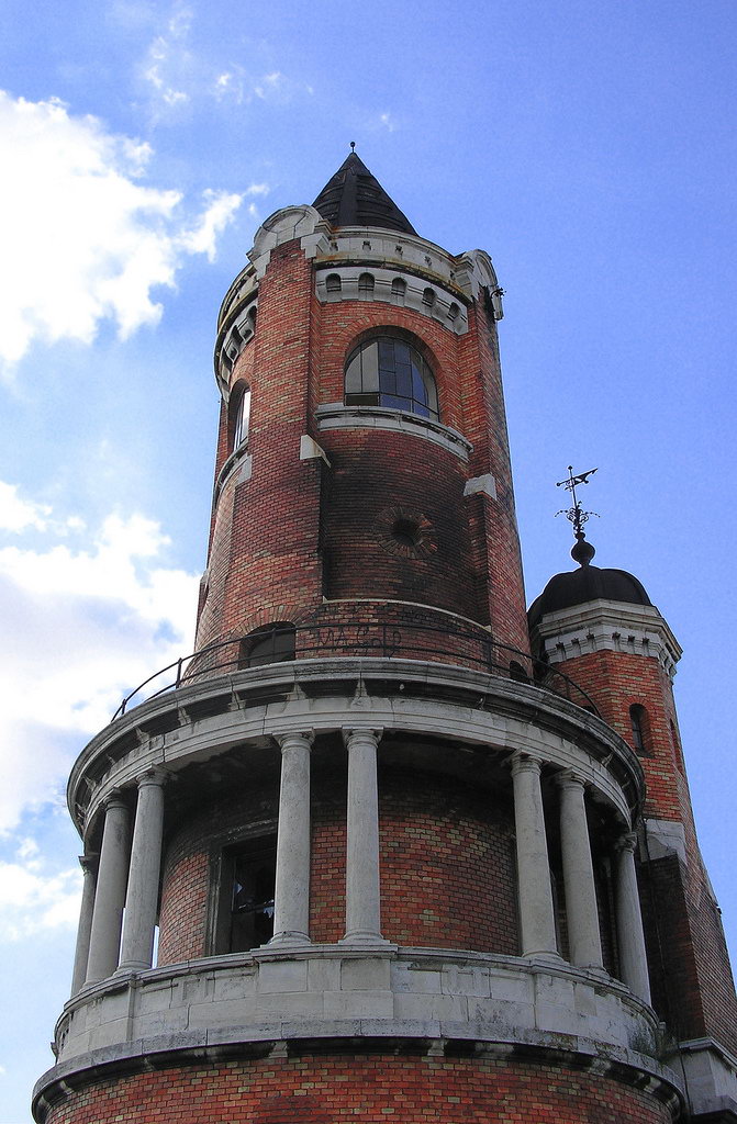
The tower gives the route its vertical argument. Gardoš Tower was built in 1896, and local tourism pages describe it as a millennium monument tied to the Hungarian statehood anniversary, the southern marker in a wider Austro-Hungarian commemorative geography.[1][7] It is only 36 meters tall, which is exactly why it works here.[7] This is not a skyline-observation deck that dominates the city from above. It is a local high point that lets Zemun's roofs, the Danube, and the flatter land beyond align just enough for orientation.
The local move is to avoid making Zemun a vague "old quarter plus lunch" drift. Belgrade Beat describes Zemun quay as sitting on the Danube's right bank, with the official name Kej Oslobođenja, beginning below Gardoš hill and extending toward New Belgrade.[3] That geography matters. If you come down from the tower to the water, the route has a clean sequence: old town above, quay below, broad river to your left or right depending on direction, and a visible way out instead of another loop through the center.
Why Zemun should be one disciplined place, not a half-day sprawl
The strongest version is compact. Take public transport from the center, get off near Zemun's core, climb first, then come down to the quay. The Tourist Organization of Belgrade says that since January 1, 2025, Belgrade public transportation has been free across city and suburban lines, including buses, trams, trolleybuses, and BG Train.[4] PlanPlus lists several center-to-Zemun or cross-city routes, including 15 from Zeleni venac to Zemun Novi Grad, 17 to Zemun Gornji grad, 83 to Zemun Bačka, and 84 from Zeleni venac to Nova Galenika.[5] For this walk, that means you should not overpay to make the outing feel simpler. Use the bus network, then spend the saved attention on where you enter the hill.
The visitor mistake is to confuse Kej Oslobođenja with the newer Belgrade Waterfront. A recent r/serbia travel thread makes that correction bluntly: locals in the discussion identify Kej Oslobođenja as the Danube quay near Gardoš, not the new mall-and-promenade zone on the Sava, and recommend Zemun center, Gardoš, and the quay as a coherent visit.[6] A separate r/Belgrade transport thread gives the practical layer: the city is walkable in the center, public transport is free, and local mapping or transport apps can be more useful than assuming every western travel habit ports cleanly into Belgrade.[8]
That is the point of keeping the article's scope narrow. Do not add New Belgrade blocks, a museum run, a full riverboat, and a late dinner into the same Zemun paragraph. Zemun works when it has a spine. The climb explains the former border-town feel; the quay explains why it still behaves like a Danube place rather than merely a district name.
8 local moves that make the walk land
- Ride instead of taxiing by reflex. Public transport is free on ordinary city and suburban lines, so the default center-to-Zemun move should be bus first unless luggage, mobility, or late-night timing changes the equation.[4][5]
- Use Zeleni venac as the simple mental launch point. Routes such as 15 and 84 appear in the public route index from Zeleni venac toward Zemun-side destinations, which keeps the route legible from the old center.[5]
- Climb before the quay. If you start on the river, Zemun can flatten into cafes and a promenade. If you climb first, the quay becomes the release after the old-town texture.[1][2][3]
- Give Gardoš Tower the short stop it deserves. It is a marker, not a whole afternoon. Read the brick-and-stone silhouette, take the view if the visit window lines up, then move.[7]
- Check tower hours close to the day. One local tourism page lists Friday to Sunday, 16:00 to 19:00, but small-site hours can shift; the walk still works if the tower interior is closed.[7]
- Come down toward Kej Oslobođenja, not toward the nearest random terrace. The quay is the second anchor, and Belgrade Beat's description of it beginning below Gardoš is the route logic.[3]
- Hold the quay as movement, not seating. Walk at least 20 to 30 minutes along the Danube before choosing a bench or cafe; otherwise you have skipped the part that makes Zemun feel separate.
- Use the return to reset the city. After the river, go back by bus rather than forcing the whole outing into an all-day expedition. Zemun is strongest as a sharp change of grain, not as a checklist marathon.[4][5]
Non-local trapline
Mistake 1: thinking Zemun is the same thing as the Belgrade Waterfront. The better move is to keep the river systems straight. Kej Oslobođenja is the Danube quay under Gardoš; the Belgrade Waterfront is a different, newer Sava-side development with a different feel.[3][6]
Mistake 2: arriving hungry and letting the first riverside table define the outing. The better move is to climb first, because the old downtown's layered styles and Gardoš's hilltop position are what make this Belgrade route different from any generic promenade meal.[1][2]
Mistake 3: assuming a taxi is the normal visitor solution. The better move is to use the free transit system for the core approach and save taxis for late-night, luggage, weather, or accessibility needs.[4][5][8]
Mistake 4: expecting one spectacular viewpoint to do all the work. The better move is to let the route change elevation and texture: old streets, tower, descent, quay, river. Gardoš is not valuable only as a lookout; it is valuable because it makes the Danube edge feel historically earned.[1][2][3]
Concrete go details
- Best time window: late afternoon into early evening, roughly 16:00 to 19:00 if you want the best chance of matching the tower-hour pattern reported by a local tourism page, or earlier if you only need the exterior and the quay walk.[7]
- Expected spend: RSD 0 for ordinary public transport and RSD 0 for the exterior walk; add only coffee, food, or any tower admission you verify locally.[4][7]
- Queue or reservation reality: no reservation for the route itself. The only uncertainty is whether the tower interior is open when you arrive.[7]
- Navigation cue:
Zeleni venac bus corridor -> Zemun core -> Gardoš Tower -> descend to Kej Oslobođenja -> walk the Danube quay toward New Belgrade or back toward the center connection.[3][5] - Best stand-or-sit point: stand near the tower long enough to orient the river and roofline, then save the first real sit for a bench on the quay after the descent.[1][3]
- Numeric anchors worth keeping: 1896, 36 meters, January 1, 2025, bus routes 15, 17, 83, 84, 16:00 to 19:00, and 20 to 30 minutes on the quay.[4][5][7]
Zemun is not the place to prove you have "done" Belgrade. It is the place to let Belgrade loosen its capital-city script. One hill, one tower, one Danube quay, and one free ride back are enough.
Sources
- National Tourism Organisation of Serbia, My Danube PDF (2025; used for the Zemun border-town framing and Gardoš Tower's 1896 context).
- Institute for the Protection of Cultural Monuments of the City of Belgrade, "The Old Downtown of Zemun" PDF (used for protected-core boundaries, architectural layers, and urban-history context).
- Belgrade Beat, "Zemun quay" (local guide page used for Kej Oslobođenja's position below Gardoš and its Danube/right-bank route logic).
- Tourist Organization of Belgrade, "City Public Transport" (official page used for the January 1, 2025 free-public-transport rule).
- PlanPlus, "Public transport routes in Belgrade" (route index used for center-to-Zemun bus options including 15, 17, 83, and 84).
- r/serbia, "Traveling to Belgrade - First Time" (recent community thread used for local distinction between Kej Oslobođenja near Gardoš and the newer Belgrade Waterfront).
- FeelBelgrade, "Gardoš tower" (local tourism page used for tower height, construction context, and posted weekend hours).
- r/Belgrade, "Transport in Belgrade" (recent community thread used for practical transit, walking, and local mapping-app advice).
- Wikimedia Commons, "File:Gardos tower Janos Hunyadi.jpg" (documentary photographic source page for the lead image by Ivan Aleksic, dated 18 March 2008).