A fossil appears for the first time twice. Once, an organism evolves in a living population. Much later, a paleontologist meets the lowest specimen that burial, erosion, exposure, sampling, and recognition have allowed into the record.
Those moments are easy to collapse. A core log marks the first sample containing a microfossil. An outcrop notebook records the lowest graptolite in a measured section. The point acquires a line, a name, and sometimes an age. Yet the line begins as an observation in rock, not direct access to the instant a species originated.
That distinction is the discipline at the heart of biostratigraphy. Evolution gives fossils their ordering power because lineages appear, change, and disappear in a sequence that does not run backward. Stratigraphers make that sequence useful by asking why a fossil occurs where it does—and why it may be absent above or below. A stratigraphic range becomes a clock only after the rock's edits are made visible.[1][4][5]
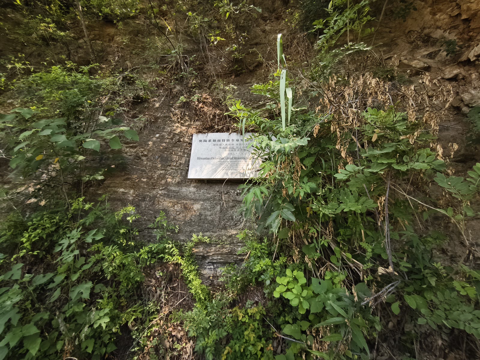
Image context: the cover is a real field photograph of the uppermost Ordovician reference outcrop near Wangjiawan in Hubei, China. At the formal section, the base of the Hirnantian Stage is fixed 0.39 metres below the Kuanyinchiao Bed, where Normalograptus extraordinarius first appears in that measured succession. The plaque marks a standard that can be revisited; the weathered layers around it are the evidence that has to be correlated elsewhere.[3][8]
The range we find is not the whole range that lived
Imagine a species that occupied an ancient sea for a million years. Its earliest populations may have been small. The right sediment may not have accumulated where they lived. Their remains may have dissolved, been eroded, or simply fallen between two samples. The oldest fossil collected so far will therefore sit somewhere above the species' actual origin. The same logic works in reverse near extinction: rare final populations can vanish from a sampled section before the lineage vanishes from the world.
This is why modern terminology separates what can be seen from what must be inferred. A bottom or lowest occurrence is the lowest identified specimen in a particular section. A first appearance datum is an interpretation of the biological event behind such observations. Petrizzo and colleagues make the boundary explicit: biohorizons are changes observed in fossil content; bioevents are past episodes such as origination, dispersal, or extinction inferred from them.[5]
The gap between the two is not a technical embarrassment. It is the problem being measured. More closely spaced samples can move a lowest occurrence downward or a highest occurrence upward. A revised identification can join two supposed species or split one long-ranging form into several shorter-ranging ones. A newly exposed section can extend the known range beyond the limits printed in an older zonation. The International Stratigraphic Guide therefore defines a taxon-range zone from the documented occurrence of a taxon and allows its vertical or geographic scope to change as evidence and taxonomy improve.[1]
Even a beautifully complete local sequence cannot by itself prove a global first or last. It can establish an observed order: fossil A occurs below fossil B; one assemblage gives way to another; a distinctive morphology arrives between two beds. Turning that order into elapsed time requires correlation and calibration.
Rock controls the invitation list
Fossils record organisms, but they also record habitat. A planktonic species carried through open water can cross sedimentary settings that would confine a reef-builder, a marsh plant, or a bottom-dwelling animal. A fossil may disappear from one section because water deepened, oxygen fell, salinity shifted, or the shoreline migrated—not because the species became extinct.
Sediment adds a second filter. Holland, Patzkowsky, and Loughney describe the fossil record as a joint product of biological history and stratigraphic accumulation. Beds do not form at a constant rate. Flooding surfaces, regressions, condensed intervals, erosion, and gaps reorganize where fossils can be preserved and where researchers can sample them. Apparent first or last occurrences may cluster around those architectural changes even when the underlying biological events were more gradual.[4]
The result is a sideways problem as well as a vertical one. Follow the same layer across a basin and the rock may change from nearshore sand to offshore mud. Follow the same habitat through time and it may migrate across several rock units. A fossil tied to that habitat can move with it, producing first occurrences at different times in different places.
That is why a biozone is formally a body of rock characterized by fossil content, not a parcel of time. The same interval can support overlapping zonations built from different fossil groups. The International Stratigraphic Guide warns that matching the same fossil-bearing facies across two sections is not necessarily time correlation: the habitat itself may have arrived at each place at a different moment.[1]
Geography can multiply a first appearance
Large datasets make this boundary more than a thought experiment. DINOSTRAT assembled more than 8,500 calibrated first- and last-occurrence records for over 1,900 dinoflagellate-cyst taxa from 188 sections. The synthesis found strong regional and latitudinal differences in many events. Taxonomic practice and age calibration matter, but so do ocean connections, temperature preferences, and climate-driven migration.[6]
A species can therefore have several meaningful beginnings: its evolutionary origin, its arrival in a basin, its first common population, and the first specimen recovered from a particular core. Only the first is a true biological origination. The others are geographic, ecological, or sampling events. They may still be excellent tools—provided they are named for what they are.
The Ordovician acritarch Veryhachium supplies a clear case. Servais and colleagues reconstructed a spread that began at high southern paleolatitudes, later reached Avalonia and Baltica, and only afterward became cosmopolitan. Its first appearance is useful for broad separation of Cambrian from Ordovician assemblages, but those diachronous arrivals cannot be treated as one precise worldwide instant.[7]
Planktonic foraminifera tell the same story at much higher resolution. Distinct Tethyan, Boreal, Austral, and transitional zonations exist because species ranges do not line up perfectly across paleolatitudes. The most useful events are those with distinctive morphology, wide distribution, repeated recovery, and good calibration; long transitions, rarity, unstable abundance, and major geographic lag weaken an event as a time marker.[5]
“Widespread” is therefore not the same as “synchronous.” Distribution improves the chance that distant sections share a fossil. It does not erase the travel time, climate boundary, or habitat preference that shaped the distribution.
Old fossils can climb into younger rock
The first three filters shorten or shift a range. Reworking can move a fossil in the opposite direction: upward into sediment younger than the organism.
Erosion can release fossils from an older bed, transport them, and redeposit them with a younger assemblage. Slumps and turbidity currents can mix material down a slope. Burrows, roots, fractures, drilling disturbance, and contamination can introduce specimens across a boundary. Slow sedimentation can condense fossils from different ages into one thin interval. The International Stratigraphic Guide treats reworked, infiltrated, transported, and condensation-mixed fossils separately from remains thought to be indigenous for exactly this reason.[1]
Petrizzo and colleagues describe a familiar version at the Cretaceous–Paleogene boundary: rare, large, ornamented Cretaceous foraminifera sometimes occur beside small early Paleogene forms. The older shapes did not survive the extinction merely because they sit higher in a core. The surrounding sediment and fossil assemblage have to be tested for evidence of redeposition before those specimens are read as survivors.[5]
A reworked fossil is not useless. It can supply a maximum age—the new bed cannot be older than the source fossil—and it can reveal where sediment came from. It simply answers a different question. Treating it as the depositional age of the younger bed mistakes the passenger for the vehicle.
A golden spike fixes one horizon, not every local occurrence
The formal geologic time scale handles these uncertainties by anchoring a boundary to a physical reference point. A Global Boundary Stratotype Section and Point, or GSSP, specifies one horizon in one studied section. Other sections are correlated to that standard with primary and secondary signals; they do not each recreate the boundary from whichever fossil appears first locally.[2]
At Wangjiawan North, the base of the Hirnantian Stage is fixed in dark siliceous shale 0.39 metres below the Kuanyinchiao Bed. The primary marker is the first appearance in that section of the graptolite Normalograptus extraordinarius. A second graptolite, N. ojsuensis, first occurs four centimetres lower, while the Hirnantia fauna appears in the limestone 39 centimetres above. Those nearby events provide a local evidence stack rather than leaving one specimen to carry the entire boundary.[3]
The specificity matters. The boundary is not “wherever N. extraordinarius is found.” It is the defined point at Wangjiawan North, whose signal can be compared with fossil successions elsewhere. If the graptolite arrives late in another basin, is absent because the habitat is wrong, or has not been recovered because sampling is coarse, the formal boundary does not move to accommodate the local gap.
The cover photograph makes that logic physical. The reference is a weathered roadside exposure with shale, chert, and a memorial plaque. Its scientific authority does not come from visual grandeur. It comes from a measured position that preserves the primary marker in relation to adjacent beds and secondary markers, and that other workers can inspect and challenge.[3][8]
Reliability comes from overlapping imperfect clocks
No single correction makes a fossil occurrence universal. Reliability grows through redundancy.
An assemblage of several taxa can survive the local absence or misidentification of one. A lineage of changing forms can constrain order better than an isolated species. Magnetostratigraphy, carbon-isotope shifts, dated volcanic ash, orbital tuning, and other independent signals can test whether fossil events align between sections. The ICS criteria for global boundary reference sections explicitly favor abundant, distinctive, widely distributed markers, continuity of sedimentation, minimal facies change, secondary markers, and numerical dating where possible.[2]
The rock must remain inside that comparison. Sequence architecture can reveal a gap that makes a disappearance look sudden. Sedimentology can expose reworking. Paleogeography can explain a delayed arrival. Taxonomy can show that the supposedly short-ranging fossil is actually several forms—or that several names describe one variable lineage.[1][4][5]
This does not reduce biostratigraphy to uncertainty. It explains why the method is powerful. Fossils let geologists correlate sedimentary rocks that may look nothing alike, sometimes at resolution unavailable from numerical dates alone. But the precision is earned by keeping several statements separate: the lowest fossil found, the local range observed, the biological event inferred, and the time boundary formally defined.
A fossil's first appearance in a section is therefore not a failed version of its evolutionary origin. It is a located piece of evidence. Once sampling, habitat, geography, reworking, and independent clocks agree, that observation can support an event. Until then, the honest line in the rock is a beginning of inquiry—not necessarily the beginning of the species.
Sources
- International Subcommission on Stratigraphic Classification, “Biostratigraphic Units,” International Stratigraphic Guide — definitions of biozones, fossil ranges, reworking, condensation, and the limits of biostratigraphic correlation.
- International Commission on Stratigraphy, “Global Boundary Stratotype Sections and Points” — current registry and selection criteria for physical reference boundaries, primary markers, secondary signals, continuity, and calibration.
- International Commission on Stratigraphy, “GSSP for Hirnantian Stage” — formal position, primary graptolite marker, secondary markers, lithology, and locality of the Wangjiawan North reference section.
- Steven M. Holland, Mark E. Patzkowsky, and Katharine M. Loughney, “Stratigraphic paleobiology,” Paleobiology 51 (2025; published online 2024) — open synthesis of how sedimentary architecture and biological history jointly structure fossil occurrence.
- Maria Rose Petrizzo et al., “Planktonic foraminifera in biostratigraphy and biochronology,” Newsletters on Stratigraphy — open manuscript on observed biohorizons, inferred bioevents, paleogeographic diachroneity, reworking, and independent calibration.
- Peter K. Bijl, “DINOSTRAT: a global database of the stratigraphic and paleolatitudinal distribution of Mesozoic–Cenozoic organic-walled dinoflagellate cysts,” Earth System Science Data 14 (2022) — global occurrence dataset and analysis of regional diachroneity.
- Thomas Servais et al., “The palaeobiogeographical spread of the acritarch Veryhachium in the Early and Middle Ordovician and its impact on biostratigraphical applications,” NERC Open Research Archive (2014) — primary case study of geographically staggered first appearances.
- Woudloper, “Hirnantian GSSP 1,” Wikimedia Commons (photographed 2025) — source page for the Wangjiawan field photograph used as the lead image.