A newly discovered passage connects two familiar parts of a cave. Underground, that is a breakthrough. At the drawing desk, it can mean moving passages already inked onto the map. Therion is a free, open-source cave-surveying package built around this recurring problem: keeping a detailed drawing useful as the measurements underneath it change.[1]
The difficulty is that a survey returning to a known point rarely lands there exactly. Small measurement discrepancies accumulate along the route. Closing the loop distributes that mismatch through the network, revising the estimated positions of survey stations. A drawing attached only to yesterday's coordinates can therefore become obsolete precisely when the survey improves. Therion's creators, Martin Budaj and Stacho Mudrák, made this the starting problem of their 2008 account of the software.[2]
Therion gives those drawings a continuing relationship with the survey. Its download page lists version 6.4.0, released on May 7, 2026, with source code for Linux, Windows, and macOS and a Windows installer.[3] For a caving club accumulating discoveries over successive trips, the interesting feature is the ability to return to earlier work and revise it coherently.
A drawing with attachment points
Two kinds of records come back from the cave: measurements between survey stations and sketches describing the passage around them. Therion's workflow accepts centreline data entered directly or imported from other surveying tools. It also accommodates paperless collection using instruments such as DistoX and applications including TopoDroid and SexyTopo.[4]
XTherion, the package's graphical editor, provides a bridge from a field sketch to an editable map. A surveyor loads a background scan, establishes its scale, traces the relevant features, and associates the drawing with survey stations. The saved material remains text-based, despite the graphical editing process. Its documented file types include .th, .th2, and thconfig.[5]
The manageable unit of drawing is a scrap: a section of cave map containing stations and features. During output generation, Therion aligns the scrap with the calculated centreline. When the station positions change, the drawing can be warped to follow them; the original drawing data remains unchanged. Neighbouring scraps are joined as the map is assembled.[4]
An already drawn passage bend can follow its updated stations across the sheet. The surveyor keeps the drawing work while improving its placement.
Tell the map what a mark means
Therion also stores meaning separately from appearance. A line can represent a wall or the edge of a pit; an area can represent water or sand. The surveyor assigns the feature type, and the selected symbol definitions determine its final appearance when the map is generated.[4]
This separation is central to the creators' description of Therion as a language plus a compiler. Their paper distinguishes the cave description from the MetaPost graphics and TeX typesetting used to present it. Scale, symbol conventions, and page arrangement can change without requiring the underlying cave features to be described again.[2]
The unfamiliar step is compilation: the editor holds the ingredients, and the processing engine produces the publication. The PDF is one result; the editable files preserve the information needed to make another.
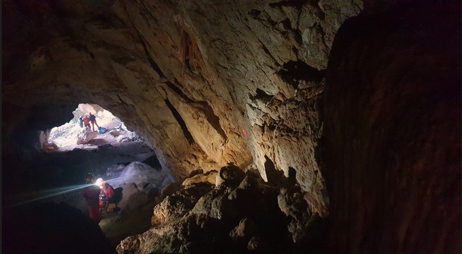
The photograph shows the earlier, physical part of this work. At a February 2024 workshop in Lovranska Draga, Croatia, participants practised DistoX calibration and surveyed nearby Oporovina cave. The Croatian Mountaineering Association's report describes field recording, exporting the data, and comparing the resulting drawings.[8] Those activities explain why the handoff to desktop software matters: a map has to carry observations made by people working among real rocks into a form other people can inspect.
A smooth map still needs a suspicious reader
Automatic adjustment cannot establish that a station was named correctly. Therion's own drawing checklist asks users to inspect loop errors and scrap distortions, noting that unexpectedly large values may indicate a wrongly plotted or named station. It recommends compiling frequently and retaining the log with the output.[6]
That advice changes how the attractive result should be read. If one passage has stretched dramatically, the useful question is what made it stretch. Check the station identities and the underlying observations before polishing the page. A finished-looking sheet can hide a mistake that remains obvious in the source records or diagnostics.
The checklist also recommends small, simple scraps, divided near junctions or changes in complexity. Small pieces can be rearranged later; a giant drawing is harder to divide after the fact.[6] This is a modest organizational choice with consequences for the next expedition, when someone needs to insert a connection into work they did not originally draw.
There is a useful outside perspective in Steve Emms's 2023 LinuxLinks profile, which introduces Therion through its purpose of archiving survey material close to the original notes and sketches.[7] That emphasis suggests a better measure of success than the first handsome export: can another surveyor understand the records and continue the map?
Start with a passage someone else can rebuild
For a small volunteer team, a sensible first project is one short, familiar survey, with an experienced surveyor reviewing the measurements and a second person learning to reproduce the output. The official downloads include sample cave datasets, including Rabbit Cave with plan and extended-elevation examples.[3] These offer a way to learn the process before taking on a club's accumulated archive.
Keep the sketches, editable files, configuration, software version, and output together. Agree on names and review changes in small batches. This is a proposed working practice, especially valuable when contributors rotate between trips. If only one person can reconstruct the project, the club has moved its dependency from a drawing desk to a laptop.
Therion's appeal grows with the prospect of returning. A passage discovered next year, or a measurement corrected tomorrow, can become part of the same continuing work. The reward for learning its conventions is a map that remains open to the next observation.
Sources
- Therion, “About Therion” — project purpose, open-source licensing, platforms, and automatic map updates.
- Martin Budaj and Stacho Mudrák, “Therion – Digital Cave Maps,” 4th European Speleological Congress, 2008 — loop closure, the compiler model, and separation of cave data from presentation.
- Therion, “Downloads” — version 6.4.0, May 7, 2026, installation options, and sample datasets; checked September 25, 2026.
- Therion, “Workflow” — field-data inputs, scraps, station alignment, feature types, and map generation.
- Debian, “xtherion(1)” — graphical editing of scans and survey drawings, text-based project files, and supported file types.
- Therion wiki, “Drawing Checklist” — scrap size, frequent compilation, distortion checks, and retaining logs.
- Steve Emms, “Therion – processes survey data and generates maps or 3D models of caves,” LinuxLinks, September 11, 2023 — independent project profile emphasizing preservation of survey notes and sketches.
- Croatian Mountaineering Association, “Seminar o digitalnom topografskom snimanju speleoloških objekata,” March 3, 2024 — report and photograph from the February 24–25 digital cave-survey workshop at Lovranska Draga and Oporovina; in Croatian.