A photograph of a damaged culvert can be perfectly sharp and still leave the office with a problem: which crossing was it, what did the inspector observe, and where should that information go? QField, the free, open-source fieldwork application built around QGIS, gives those observations a prepared home. It takes the desktop project's maps and forms onto a phone or tablet, where a person can collect information against the features they are inspecting.[1][2]
Its appeal becomes clearest when the walk is over. A useful survey must bring back enough context for someone else to understand what happened. QField supplies the tools for that round trip; the project designer still has to decide what belongs together.
Give the observation somewhere to land
In Milvignes, Switzerland, a municipal river survey began with a familiar combination: map, notebook, camera. The QField case study describes replacing that arrangement with a tablet project whose input tables were designed with the technician. One table recorded river sectors and their structural condition; another held individual photographic observations and remarks. River and cadastral layers supplied the background.[2]
That division is more revealing than a screenshot of the app. The condition of a stretch of channel and a photograph of one damaged element describe different things. Giving each an appropriate record makes it easier to preserve that distinction when the survey reaches the office.
The project reports surveying 10,894 metres of watercourses in under three days, followed by two hours of office processing. Those are the participants' results for this assignment, rather than a controlled productivity comparison.[2] The transferable idea is the preparation: decide where the answers will go before someone is standing beside the water.
QField's design principles put that preparation in QGIS. Layer styling, tailored forms, and input validation are configured on the desktop, leaving the smaller field interface focused on the task. The applications share a rendering engine, so the map's visual language can travel with the project.[1]
A form can carry a small part of the method
In QGIS, Vector Layer Properties → Attribute Form is where a project designer chooses how each attribute is entered. QField supports controls including dates, checkboxes, ranges, and Value Map selections, alongside text and attachment fields. Defaults can use QGIS expressions, and constraints can check whether entered values satisfy a rule.[3]
Consider an illustrative culvert survey. A controlled condition list could distinguish clear, partly blocked, and blocked. A required identifier could prevent an otherwise convincing record from being saved without a way to find it again. These are choices for the survey designer to configure, not a ready-made QField inspection standard.[3]
There is a limit to what such controls establish. A valid choice can still be the wrong observation. My reading of the workflow is that forms reduce ambiguity in recording; training and review have to address ambiguity in the world.
The camera also has a place in this design. QField's Attachment widget can capture images, and its documentation describes a related child table for giving one feature several photographs. Each photo can belong to the inspected object without forcing every image into a separate, unrelated survey point.[5]
Offline work needs a way home
For a first encounter, QFieldSync's manual cable workflow makes the moving parts visible. This QGIS plugin packages a working copy, which is transferred to the device. The crucial layer setting is Offline editing: it records changes in a changelog so they can later be applied to the original source. Copy transfers a file without that change tracking. A map that opens successfully therefore does not, by itself, prove that the intended synchronization path is ready.[4]
On return, open the original desktop project, bring back the modified project folder, and use Synchronize from QField. The manual workflow documentation specifies one synchronization per export; create a new package for another collection round. It also provides basemap packaging for work without a connection.[4] These details apply to the cable workflow described here; QFieldCloud provides a separate route for distribution and synchronization.[1]
Photographs need their own attention. Attachment fields hold paths to separate media files; the attachment guide lets the designer configure naming expressions and additional directories.[5] The form documentation recommends relative paths and explicitly calls for copying media directories during manual synchronization.[3]
That explains an otherwise puzzling failure: the inspection row can arrive while its picture does not. A returned filename is not proof that the file travelled with it.
What the map cannot settle
A second boundary is location quality. QField can use a device's internal positioning or an external GNSS receiver. Its positioning settings can enforce an accuracy requirement, blocking the digitizing of vertices locked to GNSS when the accuracy indicator is red.[6] This is useful feedback at collection time. It does not establish that the observer selected the correct culvert, and installing the app does not improve the underlying receiver.
An independent 2024 assessment by Václava Maťašovská, Josef Kratina, and Radim Kabeláč supplies a practical counterweight to the project examples. Writing from the T. G. Masaryk Water Research Institute, they describe QField work in Krkonoše National Park that mapped about 2,000 point objects at four sites. Changes to the data model during fieldwork required the resulting stages to be reconciled in desktop QGIS.[7]
That experience suggests a useful boundary for a small team already comfortable with QGIS: start with a modest, stable form and a named person responsible for bringing the data back. Larger teams need an explicit process for concurrent edits and changes to the survey structure. Open source makes the workflow available to inspect and adapt; it does not make those coordination decisions disappear.
The return trip can be a cable
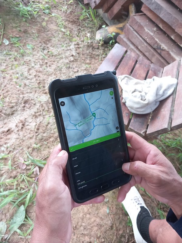
The device in the photograph belongs to a different setting: community mapping in Sarawak with the Bruno Manser Fonds. In the published account, communities help determine the features, names, attributes, and languages that their maps should contain. Unreliable internet makes cable transfer a normal part of the work. Collected data return to a local computer, while wider sharing and backup can follow when a connection is available. The team also keeps versions and sometimes resolves differences manually.[8]
This is why QField is worth exploring beyond the promise of putting dots on a mobile map. The field project can carry decisions made with the people who know the place, then return their observations in a form others can use.
For a first rehearsal, my recommendation is deliberately small: prepare one inspection layer, take it outside without a connection, add an observation and a photograph, and bring both back. Ask a colleague to open the image and explain the record without your help. That is the point at which the survey has made it home.
Sources
- QField documentation, “Principles” — desktop preparation, QGIS compatibility, and transfer approaches; consulted October 18, 2026.
- QField, “River State Survey using QField” — Municipality of Milvignes case study, table design, and reported field and office results.
- QField documentation, “Simple attribute form configuration” — widgets, constraints, defaults, and attachment paths; consulted October 18, 2026.
- QField documentation, “QFieldSync for Cable Packaging” — layer actions, basemaps, and the manual return workflow; consulted October 18, 2026.
- QField documentation, “Attachment widget” — related photo tables, file naming, and additional media directories; consulted October 18, 2026.
- QField documentation, “All about GPS, GNSS and NTRIP” — positioning sources and the scope of accuracy requirements; consulted October 18, 2026.
- Václava Maťašovská, Josef Kratina, and Radim Kabeláč, “QFIELD – mobile application for data collection established on the principles of open source software,” VTEI 2024/2, pp. 22–28 — independent review and field experience, especially the Krkonoše project on p. 27.
- Bruno Manser Fonds account, “Community-led mapping for land rights and forest protection in Sarawak with QField,” QField — community project design, cable transfers, version reconciliation, and the accompanying field photograph.