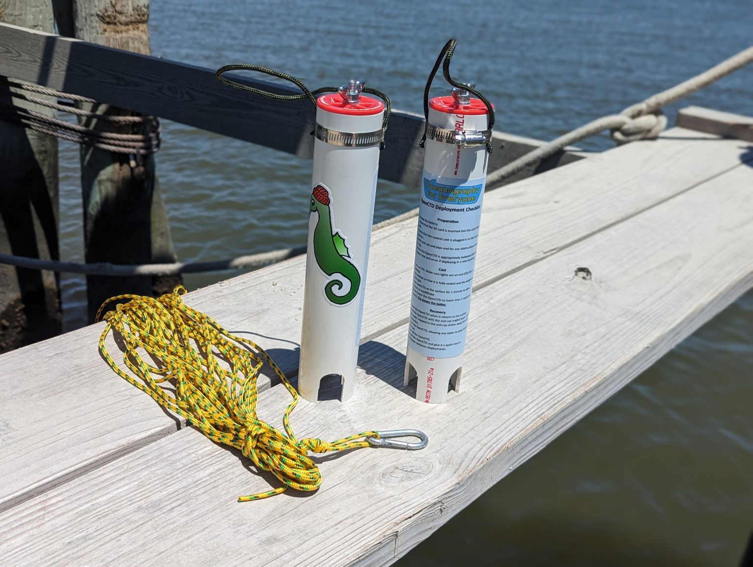
A length of PVC pipe, a battery, an Arduino-compatible controller, and sensors at the wet end: OpenCTD makes an oceanographic instrument look approachable. It is an open-source project for people who want to investigate coastal water and maintain the equipment themselves. The useful introduction starts with what comes back from a deployment: measurements that a local team can read, check, and collect again.[1]
CTD stands for conductivity, temperature, and depth. Lowering the instrument through the water produces a vertical profile: how conditions change beneath the surface. Conductivity helps determine salinity, while pressure supplies the depth measurement. NOAA describes this combination as a basic tool for understanding the water column.[2]
There is a timely reason to revisit the project. On June 22, 2026, cofounder Andrew Thaler announced Rev8, replacing the earlier trio of temperature sensors with a PT1000 probe and amplifier. The redesign also gives sensors individual connections and removes the old wiring harness, which he identifies as a frequent failure point. His launch estimate was about $400 for parts and consumables; that is a dated materials estimate, with workshop labor and equipment still to arrange.[3]
A project you can open in two senses
The repository contains firmware, support programs, construction documentation, and hardware designs. Its recommended controller is the Adafruit Adalogger Feather M0. For someone accustomed to software projects, the unfamiliar part is that a checkout leads toward soldering, a waterproof housing, and an instrument that must survive retrieval. The familiar part is the ability to inspect and modify the program that collects the data.[1]
Openness has a specific boundary here. The authors' 2024 paper says the firmware and hardware schematics use the MIT license, while identifying the Atlas EZO conductivity circuit as a component that is itself closed source. Building an OpenCTD therefore provides substantial control over the assembled instrument without removing every commercial dependency.[6]
Independent coverage has long recognized documentation as part of the attraction. In her 2020 Hackaday introduction, Kristina Panos singled out the construction guide's treatment of components, assembly, and calibration.[8] That remains a useful way to assess the project: a parts list becomes more valuable when another person can follow the work beyond the first successful power-on.
The cast becomes an ordinary file
The Rev8 firmware makes the recording process unusually easy to follow. EC_SAMPLING_FREQUENCY sets the conductivity reporting interval in whole seconds; its default is one second. When conductivity data arrive, the program also reads temperature, pressure, and the clock, then writes a comma-separated record to the microSD card.[4]
The sketch creates a filename such as CAST000.CSV, advancing to an unused numbered name. Its header names date, time, pressure, temperature, and conductivity. These are concrete places to inspect when diagnosing an empty card, checking timestamps, or writing an importer. The code also advises changing the conductivity interval for slower logging, rather than inserting an extra delay that could interfere with incoming readings.[4]
The Rev8 manual instructs users to remove the card and read it with a computer after deployment.[5] Preserve those raw records so later analysis can be revisited.
Calibration travels with the hardware
The values in that file still need interpretation. The manual describes deriving salinity from conductivity, temperature, and pressure. Depth conversion needs a surface-pressure reference: air pressure is already present before the instrument enters the water. It recommends using the pressure immediately before immersion for that reference.[5]
Conductivity calibration uses two known solutions and the program Serial_for_EC_Calibration_m0.ino, with attention to temperature. Each control unit is calibrated to its sensor package; exchanging units between instruments requires recalibration.[5]
Electrical operation does not establish measurement accuracy. Calibration records help the next person understand the results.
Alaska supplied both profiles and failures
The SEAoTech program offers a useful account of what happens after the workshop. Its February 2024 final report describes OpenCTDs built by students in Homer and Anchor Point, Alaska. A Chapman School instrument deployed in spring 2022 flooded. Another, deployed in autumn 2023, recorded profiles in the harbor and bay. Strong currents had pulled instruments sideways during earlier deployments, prompting the team to add more weight.[7]
The report also flags a likely high salinity calibration in a Homer Flex instrument's plotted profile and notes that revised calibration procedures were developed during the program.[7] These observations make the educational achievement more concrete. Students reached the stage where waterproofing, deployment conditions, and calibration could change the evidence they brought home.
Earlier validation also needs its date attached. The 2024 Oceanography paper tested the preceding sensor configuration and reported a mean salinity deviation of 0.35 practical salinity units against a commercial probe across the tested range, with a peak deviation of 1.02. The authors explicitly distinguish its capabilities from high-end instruments used for finer measurements.[6] Those results provide context for the project's development; they do not establish the performance of every Rev8 assembled in a different workshop.
Build the capacity to return
For a small coastal group or teaching lab, a reasonable starting point is one instrument, a narrow local question, and a partner able to check the measurements. Someone needs responsibility for the enclosure and deployment, and someone needs to understand the records and calibration; in a small team those roles can overlap. Time for those tasks belongs in the project budget alongside the parts.
Rev8's individual sensor connections, internal protective housing, and seawater-sensitive power cutoff show the developers addressing the physical interruptions that can end a field session.[3] My reading of the project is that its strongest promise lies in repeatability of the work: another cast, another calibration check, another person able to repair the instrument. The first readable file is the beginning of that capability.
Sources
- Oceanography for Everyone, OpenCTD repository — project purpose, recommended controller, software, documentation, and hardware resources; checked September 29, 2026.
- NOAA Ocean Exploration, “CTD” — the measurements and purpose of conductivity-temperature-depth instruments.
- Andrew Thaler, “The next OpenCTD is here!”, Southern Fried Science, June 22, 2026 — Rev8 changes, launch materials estimate, and photograph.
- Oceanography for Everyone, OpenCTDm0Rev8.ino, repository snapshot b74b3ace — sampling interval, sensor reads, timestamps, and numbered CSV output.
- Andrew Thaler and contributors, Construction and Operation of the OpenCTD, sixth edition, June 2026, pp. 46–54 — calibration and data management.
- Andrew Thaler, S. Kersey Sturdivant, Russell Y. Neches, and J. Jacob Levenson, “The OpenCTD: A Low-Cost, Open-Source CTD for Collecting Baseline Oceanographic Data in Coastal Waters,” Oceanography 37(2), 2024 — licensing boundaries, earlier configuration, validation results, and measurement limits.
- Katie Gavenus and colleagues, Student Engineers Advancing Ocean Technology (SEAoTech), BOEM 2024-007, February 2024, pp. 7–9 — student-built instruments, deployments, flood damage, and calibration observations.
- Kristina Panos, “Oceanography As Open As The Seas,” Hackaday, January 17, 2020 — independent coverage highlighting the project's construction and calibration documentation.