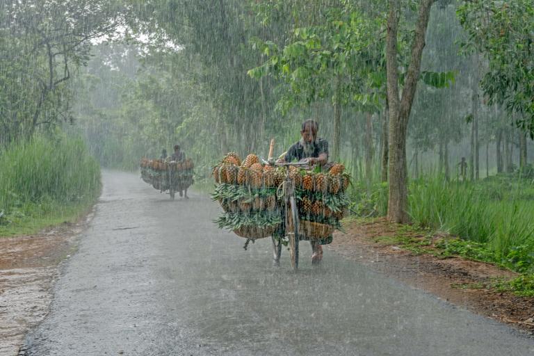
As of 2026-10-15 04:33 UTC, South Asia's seasonal forecasters are pointing to sharply different rainfall prospects across the region. In an October 14 report, the World Meteorological Organization highlighted expectations of normal to above-normal October–December rainfall in northwestern areas and parts of the east and south, including island nations. Much of central and southern peninsular South Asia faces a tilt toward below-normal rain.[1]
Yet India's next few days could be wet. The India Meteorological Department's October 14 bulletin said conditions were becoming favourable for northeast monsoon rains to begin over the southern peninsula on October 15. It forecast a wet spell with isolated heavy falls during October 14–19. That was a forecast of approaching onset, not confirmation that onset had occurred.[3]
The two announcements describe different timescales. Their immediate significance for agriculture and water management is that a season with reduced rainfall prospects can still open with disruptive downpours.
A regional forecast with several climates inside it
The 35th South Asian Climate Outlook Forum met on September 24 and October 1, combining models with expert assessment. Areas without a favoured rainfall category retain historical probabilities. Maximum and minimum temperatures are generally expected to be normal to above normal.[2]
Three dated findings define the current picture:
- October 1, regional consensus: the outlook covers October–December and describes probabilities across the region. Confidence is in what the published assessment says; actual rainfall remains uncertain.[2]
- October 14, WMO report: the regional pattern reaches a wider audience as the southern rainy season approaches. This is a report on the consensus, rather than a separate forecast confirming it.[1]
- October 14, 13:40 IST, IMD bulletin: the short-range forecast identifies an approaching wet spell. Its dates and locations require checking against subsequent national updates.[3]
The term winter outlook can conceal a geographical difference. The forum's planning note distinguishes the northeast monsoon affecting southern areas in October–December from the later influence of western disturbances across northern areas. It explains why seasonal outlooks are needed at different points in the autumn. Southern India, Sri Lanka and the Maldives are entering a period whose rains matter substantially to agriculture; northern winter precipitation follows a different circulation pattern.[4]
That distinction matters when reading a regional headline. A wetter prospect in one part of South Asia cannot be transferred to another simply because both appear under the same seasonal label.
Heavy rain can fit inside a drier season
IMD's bulletin made the immediate risk concrete: it forecast isolated very heavy rainfall on October 15 over Kerala and Mahe, and Tamil Nadu, Puducherry and Karaikal. These are forecasts for particular areas and days within a much longer season.[3]
The Met Office's guidance explains the statistical distinction. Seasonal predictions describe averages over a period and area; they allow considerable variation within both. A favoured category also leaves room for other outcomes. A hypothetical 45% chance of below-normal rainfall, for example, would still leave a combined 55% chance of near-normal or above-normal rainfall. Those illustrative percentages are not values assigned here to any South Asian location.[5]
SASCOF identifies passing weather systems as a limit on predictability. The statement uses a one-degree forecast grid and directs readers to national services for detail.[2]
For a grower, the practical inference is that seasonal water availability and the next harvesting window require different information. For a reservoir operator, a lower seasonal total would not by itself establish that every incoming flow will be small. These are implications of the forecasts' scope, not reported outcomes.
An ocean forecast that still needs reconciling
The sources also differ on one background influence. SASCOF expects neutral Indian Ocean Dipole conditions to continue through October–December.[2] WMO's October 8 global update instead describes a positive dipole expected to peak in October and then weaken, with a seasonal anomaly around +0.5°C.[6]
Both accounts point to a strong Pacific El Niño influence, but their Indian Ocean projections should not be silently combined. WMO's global update also forecasts further El Niño intensification toward December. The documents reviewed here do not establish why their dipole assessments differ. An updated regional statement or an explicit explanation from the forecasting centres would clarify the discrepancy.[1][6]
What changes for planning now
The following are planning scenarios, rather than additional weather forecasts. The base case, while the published outlook remains in force, is to retain its regional rainfall distinctions and update operations from national bulletins. An upside would be manageable rain that improves measured soil moisture and storage; those observations would support easing local water concerns. A downside would be damaging downpours followed by sustained deficits; short-range warnings and accumulating rainfall shortfalls would trigger separate responses.
A short review sequence keeps those decisions tied to evidence:
- Next 24 hours: check IMD's update for onset confirmation and revised local warnings before using the October 14 bulletin operationally.[3]
- Next seven days: compare observed rain with local requirements. One wet spell cannot determine the final seasonal total.[5]
- Next 30 days: revisit national seasonal guidance and the Indian Ocean assessment. A revised local outlook invalidates plans based on an older regional category; a new hazard warning requires immediate attention regardless of that category.[2][6]
Sources
- World Meteorological Organization, “El Niño influences South Asia winter climate outlook,” October 14, 2026 — regional news report and Kazi Md Jahirul Islam photograph.
- South Asian Climate Outlook Forum, “SASCOF-35 Outlook for the 2026 October to December Season Rainfall and Temperature over South Asia,” September 24 and October 1, 2026 — consensus statement, forecast scale and uncertainty.
- India Meteorological Department, press release, October 14, 2026, 13:40 IST — anticipated northeast monsoon onset and short-range rainfall warnings.
- Regional Climate Centre Pune, “35th Session of South Asian Climate Outlook Forum and Climate Services User Forum: Concept Note,” 2026 — distinct southern and northern seasonal forecast windows.
- Met Office, “How to use our long-range predictions” — interpretation of seasonal averages, probability categories and local variation.
- World Meteorological Organization, “Sea-surface temperatures reflect strengthening El Niño,” October 8, 2026 — global seasonal outlook and Indian Ocean Dipole projection.