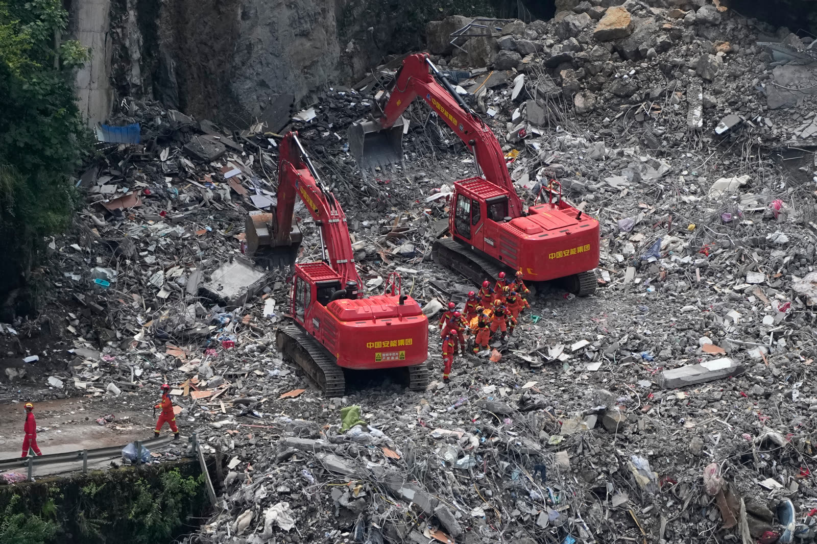
As of 2026-07-19 08:35 UTC, eight people were confirmed dead and 34 remained listed as missing after a mountainside collapsed onto residential buildings in Pengshui County, Chongqing. Ten people recovered alive were reported stable, one of them already discharged. On Saturday, dogs and detectors found signs of life beneath the rubble; the latest public account reviewed for this report did not say that person had yet been brought out.[1]
That sign makes speed essential. The slope makes indiscriminate speed dangerous. Officials say loose rock remains above the search area, including blocks large enough to threaten crews and survivors if excavation changes the debris load or another collapse begins. Pengshui's rescue is therefore one operation on two clocks: reach possible survivors quickly, but map, monitor and remove material in an order that does not create a second disaster.[1][3][5]
The casualty and missing-person counts may change as teams identify residents, search buildings and reconcile evacuation records. Missing does not mean confirmed beneath the debris, and a detected sign of life does not establish a survivor's condition. Those are the central uncertainty boundaries at this as-of time.
The Verified Record
| Time and source | What is established | Confidence note |
|---|---|---|
| About 08:00 China Standard Time, July 17 — Reuters | A community worker saw scattered falling rock and issued a warning; more than 60 residents were ordered out before the main collapse.[6] | Credible independent chronology based on the county briefing. It does not establish when every resident received the warning or how many had cleared the core zone by 09:08. |
| 09:08 CST, July 17 — county and state-media accounts | The main collapse struck Hanjia subdistrict, bringing down more than ten residential buildings.[1][6] | High confidence in the reported time and location. The underlying cause remains under investigation. |
| 18:30 CST, July 17 — Pengshui briefing | Eighteen people had been recovered: ten alive and eight dead. More than 1,100 people had been relocated, while 34 were reported missing.[2] | Official snapshot. The missing count is a live reconciliation figure, not a confirmed count of people in a specific void. |
| July 17–18 — geological assessment | Officials estimated a roughly 60-by-30-by-10-metre collapse body, about 18,000 cubic metres in total, with the largest individual unstable mass about 3,000 cubic metres.[3] | Preliminary field dimensions. They describe scale and residual hazard, not a completed forensic cause analysis. |
| July 18–19 — active search | More than 800 personnel were assigned across two flanks and the river-facing side; excavators, hand searches, dogs and life detectors were being combined. AP reported more than 120 experts at the scene and signs of life detected on Saturday.[1][7] | Strong evidence that rescue continued Sunday. Public reporting does not yet provide a completed search map or a current person-by-person ledger. |
Why The Search Cannot Be A Simple Dig
The visible wreckage is not a flat pile. It lies below a steep rock face beside the Wujiang River, where buildings, boulders and fractured material have come to rest at different levels. Local reporting says teams divided the site into three working directions: the left and right sides of the central collapse area and the river frontage below it. Mechanical excavation advances from opposing directions while people, dogs and detectors perform shallower searches.[7]
That layout matters because heavy machinery solves one problem by creating another. Excavators can move volumes that hand crews cannot, but a bucket can disturb a survivable void, shift a boulder or change support at the foot of the slope. AP reported that rescuers were mapping a careful route toward the Saturday sign of life because an uncontrolled excavation could trigger further collapse.[1] The correct measure of progress is consequently not tonnes removed per hour. It is searched space cleared without losing access, evidence or safety.
The hazard above the debris remains part of the rescue scene. Geological experts described isolated dangerous blocks at the top and sides of the exposed face and warned that intense rain or sustained heat could contribute to another failure.[3] The Ministry of Natural Resources says more than ten monitoring devices were installed on unstable ground behind the collapse and in the search area. It also ordered drone surveys, before-and-after remote-sensing comparisons, three-dimensional mapping and acquisition of satellite imagery to support the command post.[5]
Those tools do not make the slope safe. They make changes more observable. Their operational value depends on whether readings have defined thresholds, whether a warning reaches every crew immediately, and whether teams can withdraw along routes that remain open. A monitor without a stop-work rule is only a record of movement.
The Warning Saved People, But It Does Not Close The Case
The known pre-collapse sequence contains both a successful intervention and unanswered questions. A neighbourhood grid worker reportedly noticed small falling rocks around 08:00, after which local authorities began moving people. The major failure came at 09:08 while evacuation was still under way. Officials say more than 60 people left the core area before the collapse and more than 1,100 were later moved from the wider zone.[2][6]
That early action almost certainly reduced exposure. It should not be turned into a complete explanation of preparedness. The public record does not yet show when slope movement began, what prior inspections found, whether instruments covered this face before July 17, how addresses and occupants were counted, or why some residents remained in the impact area. Nor does it establish the full causal chain behind the failure. AP describes the event as rain-triggered, but the official investigation still has to separate the immediate weather trigger from geology, drainage, earlier deformation and any human alteration of the slope.[1][6]
The proper near-term question is not whether the warning system “worked” or “failed” in the abstract. It is which link worked quickly enough to move 60-plus people, which link left others exposed, and whether the evidence needed to answer that can be preserved while rescue takes priority.
What Changes Over 24 Hours, 7 Days And 30 Days
Next 24 hours: the rescue command needs a public ledger that distinguishes people recovered alive, confirmed dead, located but not reached, and still unaccounted for. Families need one consistent update channel. Crews need current slope readings, weather triggers, withdrawal routes and a single authority able to pause machinery. Newsrooms should time-stamp every toll and avoid converting “missing” into “buried” or “dead.”
Next 7 days: officials should publish a bounded search-area account: which buildings and voids have been cleared, where access remains blocked, and how the missing list was reconciled with evacuee, hospital and household records. Temporary accommodation for more than 1,100 displaced people will also move from an emergency-bed question to continuity of medicine, work, schooling and family contact.[2]
Next 30 days: an initial technical account should preserve rainfall records, photographs, drone models, monitor data, witness reports, drainage and construction records, and the warning-to-evacuation timeline. The Ministry of Emergency Management and Ministry of Natural Resources both raised their geological-disaster responses to Level II and deployed national teams; their evidence should make it possible to explain not only what fell, but how the rescue was sequenced and what nearby slopes now require inspection.[4][5]
Three Paths From The Current Search
Base path — controlled access expands. Monitoring stays within operational thresholds, teams reach the detected voids, and the official ledger changes gradually as each sector is searched. Trigger: regular site maps and casualty updates show new areas cleared without additional slope movement or rescuer injury.
Upside path — viable voids produce more survivors. Detectors, dogs and witness information converge on accessible pockets, while opposing excavation routes shorten the distance without destabilising the face. Trigger: officials confirm live contact or additional rescues and explain how access was achieved.[1][7]
Downside path — the slope or weather closes the site. New cracks, falling rock, monitor alarms or intense rain force repeated withdrawals and narrow the safe excavation window. Trigger: a formal stop-work order, an expanded exclusion zone or evidence of another collapse. Such a pause would slow the search, but continuing through a breached safety threshold could turn rescuers into casualties.
These are conditional paths, not predictions. The base case should be revised immediately if a new official toll, a successful rescue, loss of detected life signs or material slope movement changes the operating picture.
The Checklist For The Next Update
- Attach a UTC time to every casualty, survivor and missing-person count.
- Keep missing, located, reached and recovered as separate categories.
- Report whether Saturday's sign of life persists and whether contact has been established.[1]
- Publish the search sectors already cleared and the sectors still blocked.
- State which slope or weather measurements trigger a pause, withdrawal or wider exclusion zone.[3][5]
- Preserve the grid worker's warning, dispatch and evacuation timeline for later review.[2][6]
- Do not declare a cause from rainfall alone before the geological and infrastructure evidence is examined.
Invalidation condition: this report's central “two clocks” framing should be revised if geological assessment clears the remaining face of secondary-collapse risk, or if the active search ends and the operation formally shifts to recovery. Until either happens, rescue speed and slope discipline are not competing stories. They are the same duty.
Sources
- Andy Wong and Kanis Leung, Associated Press, “Rescuers in China search the rubble for survivors of landslide that killed 8 and left 34 missing” (July 19, 2026) — latest reviewed field report, survivor status, signs of life, secondary-collapse constraint, expert deployment and source page for the documentary cover photograph.
- Chongqing Daily via Xinhua, “Pengshui landslide safely relocates more than 1,100 nearby residents” (July 18, 2026) — official briefing on the recovered, injured, dead and missing; pre-collapse evacuation; response staffing; and displaced-person support.
- CCTV News via Xinhua, “Large Pengshui collapse still carries potential for another collapse” (July 18, 2026) — preliminary dimensions, volume, residual dangerous rock and stated weather-related secondary-hazard boundary.
- Ministry of Emergency Management of the People's Republic of China, “Ministry dispatches Pengshui rescue and activates national Level-II geological-disaster emergency response” (July 17, 2026) — primary response order and national engineering and fire-rescue deployments.
- Ministry of Natural Resources via National Forestry and Grassland Administration, “All-out support for Pengshui landslide emergency response” (July 18, 2026) — primary account of the Level-II technical response, monitoring instruments, drones, remote sensing and rescue-safety mandate.
- Reuters via Internazionale, “Landslide kills eight in southwest China's Chongqing, 34 still missing” (July 17, 2026) — independent account of the first falling-rock warning, core-zone evacuation and 09:08 collapse timeline.
- Xinhua, “Pengshui landslide rescue continues” (July 18, 2026) — reported deployment, equipment, search-sector layout and methods used at the scene.