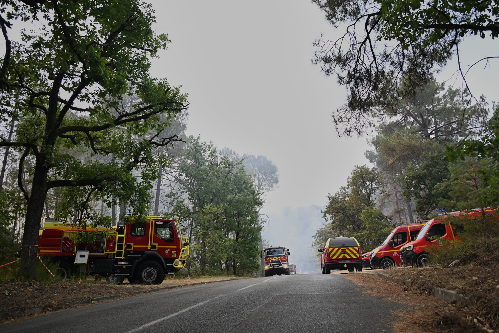
As of 2026-07-13 21:38 UTC, the wildfire in France's Fontainebleau forest had affected about 1,300 hectares, forced roughly 800 people to evacuate and was still advancing, according to the latest Reuters report available at publication. 850 firefighters, four Canadair water bombers, two Dash aircraft and three helicopters were deployed; no casualties had been reported.[2]
The scale is exceptional for a forest about 60 kilometres south-east of Paris, but the type of emergency is not wholly unforeseen.[6] Thirteen months ago, authorities staged a large wildfire exercise in the same massif. Three months ago, France formally classified 18 nearby communes as exposed to forest-fire risk.[4][5]
That sequence changes the meaning of today's fire. This is not simply a southern hazard arriving unexpectedly at the capital's edge. It is the first severe test of a risk map that has been drawn, drilled and regulated—but is still being converted into clearing rules, access plans and durable local capacity.
Situation Report
| Timestamp / source | Verified signal | Confidence boundary |
|---|---|---|
| Reuters update, July 13 | About 1,300 hectares affected; 850 firefighters and nine aircraft or helicopters deployed; roughly 800 evacuees; no reported casualties; fire still progressing.[2] | High for the quoted official update, but all operational counts can change overnight. “Affected” area is not yet a final map of severely burned habitat. |
| AP report, updated July 13 | Residential evacuations, an A6 motorway closure and earlier rail disruption; a second fire start was reported while the main fire remained unstabilized.[1] | High for observed disruption. A reopened railway or road does not imply the forest is safe to enter. |
| Météo-France, July 13 | Hot, dry and moderately windy conditions left fire danger high across Île-de-France; elevated danger was forecast to persist on July 14.[3] | High for hazard conditions. Weather explains ease of spread, not who or what ignited the fire. |
| Seine-et-Marne prefecture, June 2025 | The INFERNO 25 exercise tested a major forest fire near Noisy-sur-École with aerial drops, FR-Alert, a field command post, road closures and multi-agency coordination.[5] | High documentary confidence. A planned exercise cannot demonstrate how every system performs during a long, wind-driven real event. |
| DRIAAF Île-de-France, May 2026 | 18 communes and about 20,000 hectares were formally classified at forest-fire risk on April 13, after a regional atlas and a 2023 finding that Île-de-France was a “new fire territory.”[4] | High for the legal and planning chronology. Several implementation deadlines still run beyond this fire. |
The Drill Was Not a Prediction
INFERNO 25 reads differently tonight. On June 6, 2025, the authorities simulated a suspicious ignition in the Trois-Pignons sector spanning Noisy-sur-École, Arbonne-la-Forêt and Achères-la-Forêt. The exercise was deliberately broad: fire services from four Île-de-France departments, police, gendarmes, the national forestry office, health services, motorway operator APRR, local mayors and other partners were assigned roles. A command post was placed at Noisy-sur-École. The drill tested an FR-Alert message, forest and road closures, aerial water collection from the Seine and coordination between ground and air crews.[5]
The resemblance to the real emergency is striking but should not be overstated. The exercise used no live fire, mobilized 108 firefighters and planned one Canadair plus one heavy water-bombing helicopter. The actual incident has required a much larger force, has run through shifting winds and has disrupted the A6—the national north-south artery beside which the fire developed.[1][2][5]
The useful conclusion is neither “the drill failed” nor “the drill prepared everyone.” The drill proves that authorities had identified the command, alert, access and aviation problems in advance. The fire tests whether those rehearsed links remain coherent when the perimeter keeps moving, residents must leave, aircraft cycle for hours and crews are already stretched by fires elsewhere in France.[1][2]
That distinction matters for the after-action review. The right question is not whether the real event followed the script. It is which rehearsed decisions shortened the response, which assumptions broke under scale, and which missing resources became visible only after the exercise turned real.
A Risk Classification Between Map and Ground
Île-de-France's official language had already shifted before the smoke. A 2023 inter-inspection report identified the region as a “new fire territory.” Regional authorities then produced a risk atlas in 2024. On April 13, 2026, an interministerial order classified 18 communes across Fontainebleau, Trois-Pignons, La Commanderie and Nemours-Poligny as forest-fire-risk areas.[4]
Classification unlocks obligations, but not instantly. The regional agriculture and forestry authority says the newly classified massifs are to receive detailed legal brush-clearing requirements through a prefectural order within one year, and a departmental forest-fire protection plan within two years.[4] The current fire therefore lands in an awkward interval: the hazard is legally recognized, while some of the most consequential prevention machinery is still on its implementation clock.
That is not evidence that clearing alone would have stopped this fire. Nor does it establish that an unfinished plan caused its spread. It does identify the decisions that now deserve scrutiny: vegetation management around homes and roads, the width and continuity of access lanes, water points, closure triggers, the speed of public alerts, evacuation routes and the ability to sustain aviation in a region that historically relied less on it.
The forest's exposure is unusually complex. The Office national des forêts describes a 22,000-hectare public massif of Fontainebleau, Trois-Pignons and La Commanderie, with about 11 million visits a year, a mixture of conifers and broadleaf trees, Natura 2000 protection and thousands of recorded animal and plant species.[6] It is simultaneously habitat, heritage site, climbing landscape, commuter-region escape and operational terrain. Prevention cannot treat it as an empty fuel block; evacuation and recovery cannot treat it as an ordinary park.
What the Numbers Do—and Do Not—Establish
The reported area has moved quickly, from hundreds of hectares overnight to 1,300 hectares in the evening update.[2] That figure is an operational estimate, not a completed ecological assessment. Fire perimeters can contain lightly scorched ground, intensely burned pockets and unburned islands. The ONF's 22,000-hectare figure covers three public forests, while Reuters cited a 25,000-hectare Fontainebleau domain. Percentages built from those different boundaries should not be treated as interchangeable.[2][6]
The cause is also unresolved. Officials said that multiple starts in a compact area made deliberate ignition a possibility, and Interior Minister Laurent Nuñez reported that two people had been detained in connection with the fire.[2] A detention is not a finding of guilt, and clustered ignition points are not by themselves a completed forensic case. Until investigators establish origin, sequence and responsibility, suspected deliberate ignition is the strongest defensible wording.
At the same time, uncertainty about ignition does not erase the spread conditions. Météo-France described vegetation drought, heat and wind as the combination keeping danger high in regions that are usually less affected. It forecast continued elevated danger in Île-de-France on July 14.[3] Cause and propagation are separate questions: an investigation may identify a person or mechanism, while the weather and landscape explain why a start became a regional emergency.
Decision Impact
Next 24 hours: the operational priority is one authoritative status picture: active edge, evacuation zones, road and rail restrictions, public forest closures and the difference between “stabilized,” “contained” and “extinguished.” Residents and visitors should use prefecture, fire-service and ONF instructions rather than infer safety from rain, cooler air or a reopened transport line. Météo-France's July 14 outlook does not yet support a return to routine access.[1][2][3]
Next 7 days: Seine-et-Marne should publish a preliminary response chronology against the INFERNO 25 checklist: first alert, command-post activation, FR-Alert reach, evacuation timing, aircraft request and arrival, water-scooping constraints, A6 coordination, crew rotation and mutual aid. The comparison should identify decisions, not stage a victory lap or a blame ritual.[5]
Next 30 days: the region should use the fire record to accelerate—but not shortcut—the pending brush-clearing order and departmental protection plan. The final perimeter, structure exposure, road access, ignition evidence and ecological severity should determine priorities. A map of where crews could not move or water could not arrive will be more useful than a generic promise to “increase resilience.”[4][6]
Three Paths From Tonight
Base case — the perimeter stabilizes, then the long watch begins. Cooler or calmer conditions and sustained aerial work stop major runs, evacuations are lifted in stages, and crews spend days or weeks securing edges and hotspots. Trigger: no material perimeter expansion through a full wind cycle, followed by an official stabilization notice.
Upside case — response evidence closes the planning gap. No homes or lives are lost, agencies publish a candid after-action review, and the new risk classification rapidly produces specific clearing, access, alert and mutual-aid rules. Trigger: a reconciled fire map and public implementation timetable tied to the April classification.[4][5]
Downside case — new starts and dry wind outrun the resource plan. The active edge expands, more communities or transport corridors are threatened, and simultaneous fires force aircraft or crews to be rationed. Trigger: renewed evacuations, additional independent starts or continued growth despite the overnight deployment.[2][3]
Action Checklist
- Keep evacuation, road and forest-access notices in one timestamped public feed; an old closure map can be actively dangerous.
- Report affected perimeter, high-severity burn and ecological damage as different measures once satellite and field assessments are available.
- Protect narrow forest approaches from spectators and parked vehicles so engines, evacuation traffic and aircraft-support crews can move.
- Preserve ignition evidence and avoid describing the two detainees as perpetrators before investigators establish responsibility.[2]
- Audit INFERNO 25 against the real response, including the assumptions that failed as well as the capabilities that transferred.[5]
- Turn the April 2026 classification into named owners, dates and budgets for brush clearing, access, water supply, alerting and the departmental protection plan.[4]
The report's central interpretation should be revised if the official review shows that the new classification's preventive measures were already fully operational, that the exercise exposed no relevant coordination gap and that implementation timing had no bearing on response. Until that evidence exists, Fontainebleau is best understood as neither a freak Parisian anomaly nor a simple preparedness success. It is the event that made a newly recognized fire territory operationally real.
Sources
- Alex Turnbull, Oleg Cetinic and Suman Naishadham, Associated Press, “Fire in Fontainebleau forest near Paris triggers evacuations” (updated July 13, 2026) — event reporting, transport disruption, investigation boundary and source page for Emma Da Silva's cover photograph.
- Reuters via Boursorama, “France—Le feu n'est pas fixé à Fontainebleau, deux personnes interpellées” (updated July 13, 2026, 20:42) — latest available operational count, evacuation figure, affected area, aircraft deployment and investigation status.
- Météo-France, “Feux de forêts : le niveau de danger reste élevé” (July 13, 2026) — Île-de-France fire-danger outlook, vegetation drought and the boundary between ignition and spread conditions.
- DRIAAF Île-de-France, “L'Île-de-France concernée par le risque feux de forêt : plusieurs communes classées à risque en Seine-et-Marne et en Essonne” (updated May 21, 2026) — 2023–26 risk-map chronology, 18-commune classification and implementation deadlines.
- Préfecture de Seine-et-Marne, Exercice « Feu de forêt » INFERNO — 6 juin 2025 — official exercise dossier covering the scenario, FR-Alert, command, closures, Seine water-scooping and multi-agency response.
- Office national des forêts, “Forêt de Fontainebleau : entre landes et chaos rocheux, un espace unique en France” — official massif boundaries, visitor volume, forest composition, biodiversity and protection context.