As of 2026-06-13 20:32 UTC, Cristina is no longer a tropical storm, and that is precisely why the public-risk message can get slippery. The National Hurricane Center issued its final advisory at 0600 UTC on June 11 after the system degenerated into a weak trough near El Salvador, but the same advisory still warned that the remnants could produce 4 to 8 inches of rain, with localized totals up to 12 inches, across parts of El Salvador through that night.[3]
The shift is from a named-storm headline to a terrain-and-response problem. Cristina's peak winds were modest by tropical-cyclone standards: NASA's MODIS note says maximum sustained winds reached 45 mph, while the final NHC public advisory put the remnants at 25 mph.[1][3] But Central America's Pacific slope does not need hurricane-force wind to turn dangerous. Slow movement, saturated hillsides, short river basins, and steep terrain can make rain the main hazard after the cyclone label disappears.
What happened
| Timestamp / source | Key point | Confidence |
|---|---|---|
| June 8, NHC archive | Cristina advisories began as the Eastern Pacific system organized near Central America.[2] | High; official advisory archive. |
| June 8, AP | Cristina formed off Nicaragua with 45 mph sustained winds and tropical-storm warnings from Puerto Sandino to the Guatemala/El Salvador border.[6] | High; AP citing NHC. |
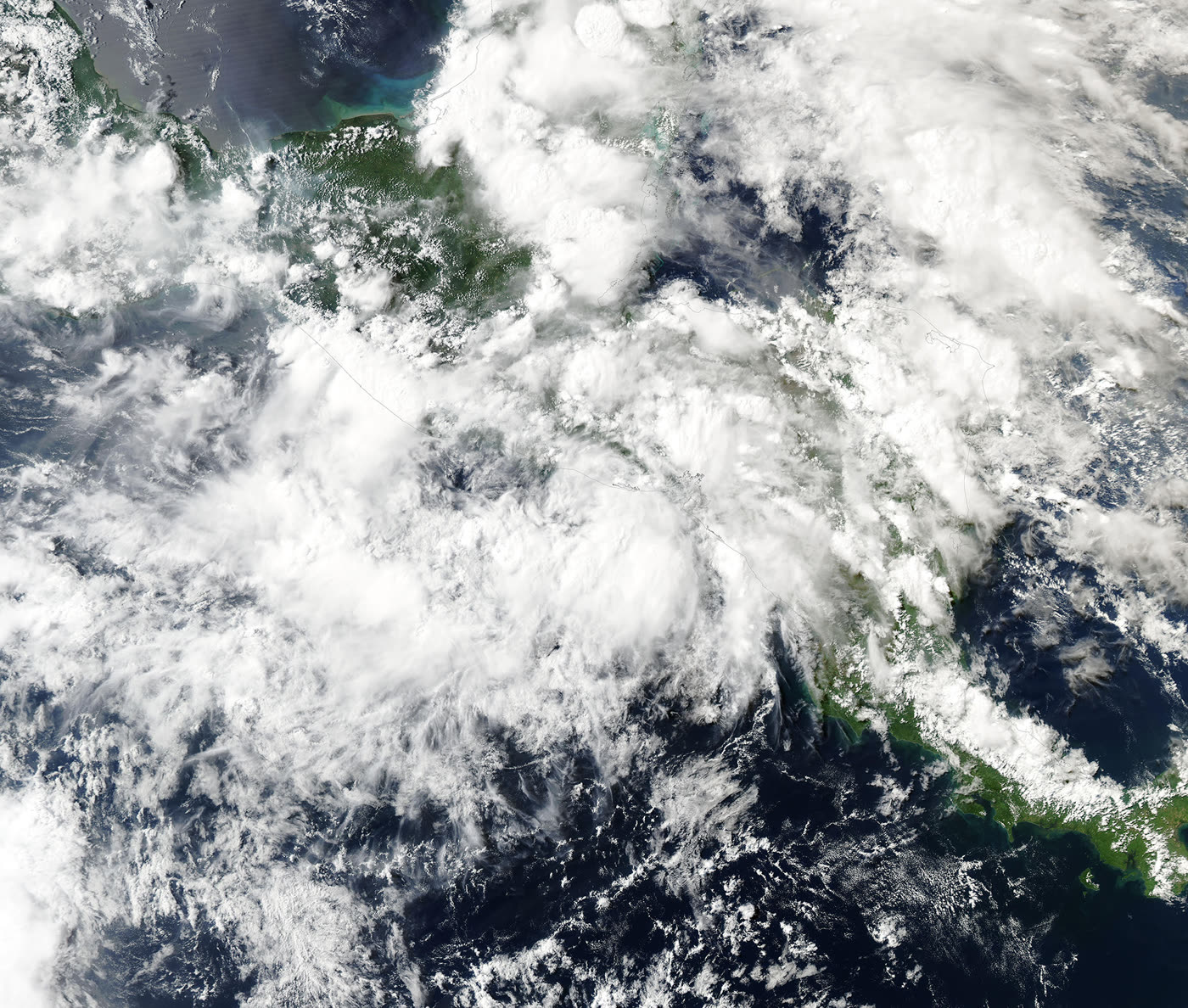
| June 10, NASA MODIS | Aqua MODIS acquired a true-color image while the storm was drifting off El Salvador.[1] | High; satellite image metadata. |
| June 11, NHC final advisory | Cristina degenerated into a weak trough near 13.2N, 89.1W, about 35 miles south of San Salvador.[3] | High; final public advisory. |
| June 10-11, relief and satellite sources | Direct Relief framed the threat around heavy rain, flooding, mudslides, and health readiness, while NOAA/NESDIS/STAR continued to identify the post-tropical cyclone location in its GOES floater.[4][5] | Medium-high; operational and satellite sources, not full damage assessments. |
The narrow factual core is clear. Cristina was a short-lived Eastern Pacific storm, the third named storm noted by NASA's MODIS write-up, and it lost tropical-cyclone structure quickly.[1] The NHC archive shows a compact advisory life from June 8 through June 11.[2] By the final advisory, coastal watches and warnings were gone, but rainfall remained the live hazard.[3]
That last point is the report's hinge. A discontinued watch can sound like relief, while the rainfall section of the same advisory can still describe life-threatening flooding and mudslides. For people in exposed drainage basins or mountain communities, the official end of the cyclone product is not the same thing as the end of the emergency.
Why the final advisory still matters
NHC's final public advisory did three things at once. First, it downgraded the meteorological identity of the system: Cristina was no longer a tropical cyclone but a weak trough of low pressure.[3] Second, it removed the formal coastal watch/warning apparatus.[3] Third, it preserved the land hazard: heavy rainfall, possible flash flooding, and mudslides, especially in steep terrain.[3]
Those messages are easy to separate in a database and hard to separate in public behavior. A storm name carries attention. A remnant trough does not. Yet the water on the ground follows topography, soil condition, drainage, and infrastructure, not naming conventions. That is why Cristina is a useful early-season warning case: a modest storm can still create a serious response burden when it stalls near land.
The satellite image helps explain the asymmetry. MODIS captured a cloud shield organized enough to span a large coastal region, even though the system's wind field never became especially intense.[1] NOAA/NESDIS/STAR's GOES floater also kept the post-tropical system tied to a specific location, 13.2N, 89.1W, matching the final advisory's center fix.[5][3] These images are not damage maps and should not be read as such. Their value is scale: the rainmaker was broad relative to the communities, roads, streams, and hillsides beneath it.
Response burden
Direct Relief said it was in communication with health partners in El Salvador and with PAHO, and described hurricane-preparedness packs, field medic packs, dengue-related supplies, personal protective equipment, and Panama warehouse staging as part of the regional readiness picture.[4] That detail matters because flooding is rarely a single-service problem. It can cut roads, isolate clinics, contaminate water, raise injury risk, interrupt medication access, and increase demand for vector-borne disease supplies after standing water accumulates.
The AP formation report, published when Cristina was still a tropical storm, carried the same broad rainfall envelope: 4 to 8 inches, with maximum totals near 12 inches, across coastal Nicaragua, Honduras, El Salvador, and Guatemala through Thursday.[6] The later NHC final advisory narrowed the live rainfall warning toward El Salvador, but it did not remove the water hazard.[3]
There is still uncertainty around realized damage in each country. NASA's MODIS write-up cites flooding from Costa Rica to Nicaragua and reports hard-hit conditions in Iztapa, Guatemala, through The Weather Channel.[1] Direct Relief's note is more about mobilization than verified impact totals.[4] NHC's advisory is forecast and warning language, not a post-event loss assessment.[3] The strongest conclusion, therefore, is not that every warned area experienced the same impact. It is that the official hazard shifted from wind to water before the public attention cycle had much time to adjust.
Decision impact
For emergency managers, the practical window is the 24 to 72 hours after advisories stop. That is when washed-out roads, delayed landslides, shelter needs, clinic access, and local water safety problems can surface after the storm name leaves national feeds. The watch item is not Cristina's center anymore; it is local rainfall totals, river response, slope failures, and municipal damage reports.
For aid groups, Cristina argues for pre-positioned medical logistics rather than a wait-for-landfall posture. A weak system lingering near mountainous terrain can create enough local disruption to require first responder kits, clinic resupply, and coordination with national health authorities even without a major wind disaster.[4]
For the public, the key instruction is boring but decisive: do not treat "final advisory" as "all clear." In flooded terrain, the better trigger is local authority guidance, visible water conditions, road closures, and whether rain bands have actually moved out.
Scenarios to watch
Base case: local flooding and mudslide risk continues to resolve as Cristina's remnants dissipate and rainfall ends. Confirmation would come from receding river levels, reopened routes, and no new emergency-health logistics requests.
Worse case: localized high rainfall over steep or already saturated areas produces delayed landslides, isolated communities, or clinic access interruptions. The trigger would be municipal reports of road failures, bridge damage, or new shelter needs after June 11.
Faster normalization: rainfall underperforms in the most vulnerable basins and emergency response remains mostly precautionary. The trigger would be clean local damage reports and no sustained humanitarian-health requests from partner organizations.
Action checklist
- Track local civil-protection and weather-office updates before regional summaries.
- Treat flooded roads and low-water crossings as closed unless local authorities say otherwise.
- Watch for delayed slope failures after rain stops, especially in steep terrain.
- For response planning, separate "wind over" from "water risk over."
Sources
- NASA MODIS, "June 13, 2026 - Tropical Storm Christina" - true-color Aqua MODIS image, acquisition date, wind peak, storm timing, and impact summary.
- NOAA National Hurricane Center, "Tropical Storm CRISTINA Advisory Archive" - full advisory timeline for EP032026.
- NOAA National Hurricane Center, "Remnants Of Cristina Special Advisory Number 13" - final public advisory at 0600 UTC on June 11, 2026.
- Direct Relief, "Tropical Depression Cristina: Storm Warning Issued for El Salvador and Guatemala Coast" - relief coordination and medical preparedness details.
- NOAA/NESDIS/STAR, "Post-tropical Cyclone Cristina at 13.2N - 89.1W" - GOES floater page and satellite position context for EP032026.
- Associated Press, "Tropical Storm Cristina forms off coast of Nicaragua, forecasters say" - formation report, initial warnings, and rainfall forecast.