The Vajont disaster is often remembered with the wrong mental picture. It sounds like a dam failure, so the mind supplies a broken wall, a reservoir pouring through a breach, and engineers discovering too late that concrete had been weak. Vajont was more unsettling than that. On the night of October 9, 1963, the concrete arch dam in northeast Italy largely survived. The catastrophe came when a huge mass from Monte Toc slid into the reservoir, threw water over the crest, and sent a violent wave down toward Longarone and nearby villages.[1][2][3]
That distinction is not pedantic. It changes the historical question. The issue is not why a dam wall broke; it did not. The question is how a hydroelectric project could keep operating after evidence had already made the mountainside legible as a danger. UNESCO's Memory of the World entry for the criminal proceedings calls the Vajont records an archive of human responsibility, not merely a file on a natural event: the proceedings ran from 1963 to 1971, drew on earlier materials reaching back before 1900, and preserved rock samples, models, seismic recordings, negatives, plates, and film footage alongside legal documents.[1]
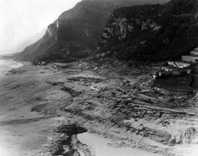
The photograph used here makes the same point from below.[5] Longarone appears as the receiving end of a system failure whose visible source is not in the frame. The town was destroyed by water that had been displaced by rock. The dam still stood above it. That is why Vajont belongs in event reconstruction: every stage matters, and the sequence is the argument.
Timeline anchors
- 1957: construction began after years of planning and approval delays, with the project carried out by SADE, the Adriatic Energy Corporation.[3]
- 1960: reservoir filling began, even as fractures, road shifts, and slope-instability concerns had already made Monte Toc a central problem.[3][4]
- November 1960: a significant earlier slide entered the reservoir, a warning event in the longer instability sequence summarized by later geotechnical work.[2][4]
- 1962-1963: the dam was nationalized into Italy's public electricity system while reservoir operations and slope movement remained bound together.[3]
- October 9, 1963, 10:39 p.m.: an enormous rock mass detached from Monte Toc and fell into the reservoir, generating waves that overtopped the dam and devastated the Piave valley below.[2][3][4]
- 1963-1971: criminal proceedings examined responsibility, evidence, and technical knowledge after the disaster.[1]
- 2023: the archival fonds of the Vajont criminal proceedings was entered in UNESCO's Memory of the World register.[1]
The warning was not abstract geology
The first stage of Vajont was not the slide itself. It was the conversion of a mountain into a known operational risk. Britannica's concise history notes that the Vaiont River gorge was known to be geologically unstable, that landslides had a local history, and that fractures and road shifts appeared during construction.[3] That matters because it prevents the easy defense that the disaster arrived from nowhere. The slope did not have to be fully understood for warning signs to be meaningful.
Later geological work gives those warning signs sharper structure. Paronuzzi, Bolla, and coauthors describe the 1963 failure as a remobilization of older unstable material on the northern slope of Monte Toc, with weak clay-rich layers, bedding-plane geometry, faults, and a basal shear zone all contributing to a slope already predisposed to move.[4] The technical vocabulary can obscure the historical force of the point. The mountain was not a single solid wall waiting passively above a lake. It was a layered, fractured, water-sensitive slope whose behavior changed as the reservoir changed.
That is the first reconstruction claim: Vajont became dangerous before the final night because the project joined two systems that could not be treated separately. The dam impounded water. The water affected the slope. The slope, if it failed, could move the water. No single component can be read in isolation.
Reservoir operations turned risk into a schedule
The second stage was operational. The dam itself was a major engineering achievement: a high concrete arch in a narrow valley, built for hydroelectric development in northern Italy.[3] But an impressive dam wall did not make the reservoir setting safe. The question became how filling, lowering, refilling, rainfall, pore pressure, and slope displacement interacted over time.
The Association of State Dam Safety's resource page for Rinaldo Genevois and Monica Ghirotti's 2005 paper summarizes the disaster in dam-safety terms: on October 9, 1963, roughly 270 million cubic meters of mass collapsed into the reservoir, overtopping the dam and hitting Longarone and other villages, with almost 2,000 lives lost.[2] It also emphasizes why the case kept generating research: the chronology before the final night, the mechanics of the landslide, and the meaning of precursor activity all became central to understanding the disaster.[2]
Paronuzzi and colleagues go further on mechanism. Their review argues that reservoir level changes between 1960 and 1963 were decisive in lowering slope stability, because water entering the basal shear zone reduced strength along the failure surface. They explicitly distinguish that reservoir-induced process from a rainfall-only explanation.[4] In historical terms, that means the catastrophe cannot be filed as weather. Rain and geology mattered, but the artificial lake changed the mountain's condition.
This is the second reconstruction claim: risk was not merely observed from a distance. It was managed through reservoir operations, and those operations became part of the event. Each filling and drawdown decision carried information, but also stress.
The disaster happened when the mountain moved faster than warning could matter
The final sequence compressed years of warning into minutes. At 10:39 p.m. on October 9, a vast section of Monte Toc detached and slid into the reservoir.[2][3][4] Britannica gives the scale as an estimated 260 million cubic meters of rock, while the dam-safety summary gives approximately 270 million cubic meters.[2][3] Those figures differ at the margins but agree on the essential point: this was not a small rockfall. It was a mountainside entering a confined body of water.
The resulting wave rose far above ordinary design imagination. Britannica states that the landslide generated a wave reaching roughly 150 to 200 meters above the dam before it overtopped the crest and flooded the narrow valley below.[3] Other reconstructions vary in wave height and water volume, but all point to the same fatal geometry: the reservoir became a displacement machine. The dam did not need to collapse for Longarone to be destroyed. It only needed to be overtopped by water accelerated through a gorge.
The most devastating wave went down toward the Piave valley. Longarone, almost directly below the dam, was nearly obliterated; Britannica notes that about 80 percent of its inhabitants drowned, and nearby Faè, Pirago, Rivalta, and Villanova also suffered casualties and damage.[3] UNESCO gives the archival death toll as 1,910.[1] The Longarone Vajont museum's own public account frames its work around the memory of those 1,910 victims and the survivors who faced total devastation.[6]
This is the third reconstruction claim: the disaster's violence came from timing, confinement, and direction. A huge slide entered a reservoir at night, displaced water upward and outward, and sent part of that water over an intact dam into a valley with towns below. The concrete wall's survival is what makes the story harder, not easier. It shows that structural integrity at one point in a system can coexist with fatal failure in the system as a whole.
The legal archive made responsibility visible
After the wave came a second historical event: the fight over responsibility. UNESCO's entry is crucial because it does not treat the Vajont criminal proceedings as routine paperwork. It describes the fonds as evidence used to demonstrate human responsibility in the landslide and flood, and notes that the collection includes 250 folders of legal acts plus non-paper annexes such as rock samples, models, seismic recordings, photographic negatives, plates, and film footage.[1]
That record matters because Vajont could otherwise be pushed back into the language of natural disaster. The mountain moved; water followed; tragedy resulted. The court and archive structure complicate that sequence. They ask what was known, who knew it, how warnings were interpreted, how corporate and public authorities framed risk, and why communities below the dam were not protected from a scenario that had become increasingly thinkable.
Britannica notes that government and SADE initially moved quickly to describe the event as natural, while several employees were eventually sentenced for negligence and manslaughter.[3] That is not the same as saying every technical detail was obvious in advance. The geological literature still debates parts of the failure mechanism, and Paronuzzi and colleagues identify disputed points around the prehistoric landslide interpretation and the exact role of clay-rich materials.[4] But uncertainty about mechanism is not the same as absence of warning. Vajont's legal afterlife exists because there was a record to examine.
This is the fourth reconstruction claim: the event did not end when the water drained. It continued through trials, files, models, photographs, and institutional memory. The archive became the place where a valley tried to insist that the disaster was not just an act of nature.
Why the intact dam matters
Vajont still unsettles because it breaks the simplest safety story. A dam can be well built and still be part of a deadly project. A wall can stand while a town below disappears. Engineers can monitor a danger and still underestimate how fast and large the final movement will be. Administrators can translate warning into procedure without translating it into protection.
The strongest historical reading is therefore not "technology failed" in a generic sense. It is more precise: system boundaries failed. The dam, reservoir, mountain, company, state, valley settlements, and warning regime were treated as if their risks could be contained in separate boxes. On October 9, 1963, those boxes collapsed into one event.
That is why the U.S. Army/USGS photograph of Longarone remains so powerful.[5] It does not show a broken dam. It shows the human landscape below an intact structure after the real failure had passed through. Vajont's lesson is that disaster history has to follow force through the whole system, not stop at the most visible artifact.
Sources
- UNESCO Memory of the World, "Criminal Proceedings of the Vajont dam disaster" - official register entry for the 1963-1971 proceedings, archival scope, death toll, and human-responsibility framing.
- Association of State Dam Safety Officials, "The 1963 Vaiont Landslide" - resource entry for Genevois and Ghirotti's 2005 paper, with event scale, casualty summary, and research focus.
- Encyclopaedia Britannica, "Vaiont Dam" - overview of construction, geological warnings, nationalization, the October 9, 1963 landslide, Longarone damage, and legal aftermath.
- P. Paronuzzi, A. Bolla, D. Pinto, D. Lenaz, and M. Soccal, "The clays involved in the 1963 Vajont landslide: Genesis and geomechanical implications," Engineering Geology 294 (2021), DOI landing page - geological mechanism, reservoir-operation role, and debate over failure conditions.
- Wikimedia Commons, "Vajont1963usarmy.jpg" - source page for the U.S. Army/USGS archival photograph of Longarone after the wave from the Vajont Dam disaster.
- Museo Longarone Vajont - Attimi di Storia, official museum homepage - local memory framing, victim count, and museum scope around images, objects, testimony, and film.