At 5:12 a.m. on 18 April 1906, San Francisco suffered a major earthquake. Yet the city’s defining loss did not come from shaking alone. The disaster escalated because three systems failed in sequence: the fault ruptured, urban lifelines broke, and emergency fire control ran out of usable options.[1][2][5]
The value of this event for modern readers is not “earthquakes are dangerous.” The sharper lesson is that catastrophe scale is often decided in the hours after the initial shock, when infrastructure fragility and command decisions interact.
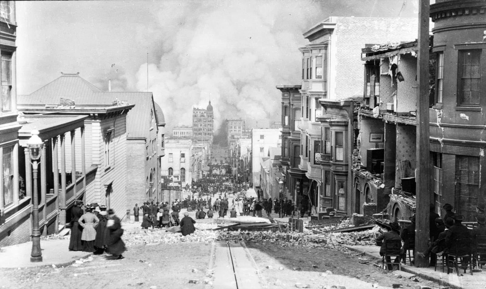
Image note: the cover image is a contemporary photograph of Sacramento Street during the 1906 fire. It is included to anchor the article’s core claim that post-shock urban fire spread, not shaking alone, dominated final city loss.
18 April, 5:12 a.m. — rupture and first shock window
USGS documentation places the main event at 13:12:27 UTC (05:12 local), with strong shaking roughly 45–60 seconds and a major rupture along the San Andreas system.[1][2] Modern reconstructions describe rupture on the order of ~296 miles (477 km) in the northern segment.[1]
That duration is short in clock time and long in city time. In less than a minute, masonry cracked, transport halted, and critical utilities were damaged. Contemporary and later investigations repeatedly pointed to one practical fact: when mains and pressure networks fail, urban firefighting capacity collapses exactly when ignition risk rises.[1][5]
18 April, morning to night — from many ignitions to a city fire field
By midday, San Francisco was no longer dealing with a single emergency scene. It was dealing with multiple moving fire fronts. Britannica’s synthesis and California Geological Survey materials align on the broad contour: a massive post-quake fire spread for several days, consuming the commercial core and surrounding districts.[5][6]
The common shorthand says “the earthquake destroyed San Francisco,” but that overstates the first phase and understates the second. USGS and state-level retellings emphasize that fire drove a large share of total destruction.[1][5] In other words, the quake created the conditions; the fire determined the final urban loss map.
19 April — emergency control without enough water
On the second day, operational choices narrowed. Reports from the period and later summaries describe efforts to create firebreaks, including dynamiting structures, while hydrant reliability remained severely degraded in key zones.[5][6]
This is the inflection point in the chronicle:
- Hazard 1: widespread ignition sources after intense shaking
- Hazard 2: impaired suppression capacity due to utility damage
- Hazard 3: emergency tactics with mixed effectiveness in dense built form
When all three occur together, each tactical error becomes expensive. The event therefore reads less like a single “natural” episode and more like a coupled infrastructure-governance failure under extreme time pressure.
Why water-network fragility became the decisive multiplier
Earthquake narratives often emphasize magnitude and fault length; those are necessary descriptors, but they do not explain urban loss concentration by district. A more operational explanation is hydraulic: once major mains and pressure regimes fail, fire suppression shifts from system response to fragmented local improvisation.[1][5]
That distinction helps explain why post-shock fire could outrun command intention. Fire lines can be ordered; water delivery cannot be improvised at city scale in minutes. In 1906, this mismatch produced a structural asymmetry: ignition opportunities expanded while suppression throughput contracted.
For historians, this is where the episode exits “disaster chronicle” and enters “infrastructure state capacity” analysis. The city was not only hit by a geologic event; it was tested on whether critical utility redundancy existed under simultaneous shock and communications stress.[3][5][6]
20–21 April — containment, then accounting
By roughly the fourth day, major fire spread was brought under control.[6] What followed was the political and statistical struggle common after large disasters: how many died, which mechanism killed most victims, and which institutions failed first.
One durable disagreement concerns fatalities. Early public figures were far lower; later reassessments pushed totals far upward, and modern summaries often reference a range that can exceed 3,000.[1][6][7] This is not just a bookkeeping issue. Death-count revisions change how policymakers and historians allocate responsibility between shaking, fire, and post-impact response.
Another durable line concerns damage attribution. A frequently cited interpretation, repeated in later syntheses, is that fire accounted for the majority of destruction in the city core.[1][6] If that interpretation holds, then resilience planning must prioritize post-shock lifeline survivability at least as much as structural seismic resistance.
21 April and after — the investigative state takes shape
The institutional turn came quickly. USGS historical documentation notes that within days, California established a formal investigation led by Andrew Lawson, producing the 1908 report that became a benchmark for modern earthquake inquiry.[3][4]
That sequence matters:
- 18 April: disaster
- ~21 April: investigation authority consolidated
- 1908: integrated technical report published
The Lawson effort did more than describe ruins. It linked observed damage, geology, and fault movement in one analytical frame, helping move U.S. earthquake science toward elastic-rebound thinking and modern hazard practice.[3][4]
Why this chronicle still has edge in 2026
The 1906 case remains high-value because it separates two questions that cities still conflate:
- Can buildings survive the first minute?
- Can systems survive the next 24 hours?
San Francisco in April 1906 shows that passing question 1 is not enough. If water, command coordination, and fire-control logistics fail together, the second phase can dominate total loss.[1][5][6]
For present-day planners, the transferable rule is plain: treat post-shock firefighting water, inter-district pressure redundancy, and decision authority under communication loss as first-order seismic policy—not as secondary emergency annexes.
Counterfactual edge: what would have reduced catastrophe scale fastest
A narrow counterfactual is defensible from the record: if usable firefighting water redundancy had held across more districts in the first 12–18 hours, aggregate fire spread would likely have been materially lower even with similar shaking damage.[1][5][6]
This is not a claim that better water systems erase earthquake harm. It is a claim about marginal control power in the decisive second phase. In a dense city, post-shock fire growth is nonlinear; modest early suppression gains can prevent large downstream district loss.
That is why 1906 still reads as a planning document in disguise. The main lesson is not retrospective blame; it is pre-positioned capability—water, command continuity, and interoperable emergency authority before the first minute arrives.
Sources
- USGS — The Great 1906 San Francisco Earthquake
- USGS ComCat event page — M 7.9 April 18, 1906 San Francisco Earthquake
- USGS — 1906 Marked the Dawn of the Scientific Revolution
- State Earthquake Investigation Commission (Lawson Report, archive copy)
- California Geological Survey — The 1906 Great San Francisco Earthquake
- Encyclopaedia Britannica — San Francisco earthquake of 1906
- UC Berkeley Seismology — 1906 Quake background page
- Wikimedia Commons source image — San Francisco Fire, Sacramento Street, 1906-04-18