The 1910 Seine flood is often remembered through postcard Paris: boats in streets, wooden footbridges, mirrored facades, and a city briefly compared to Venice. That image is accurate enough to be memorable, but it can soften the history. The flood mattered because modern Paris did not fail only at the river edge. It failed from below.
The causal chain began with weather and geography, but it became historical when water entered the systems that were supposed to make the capital modern: sewers, transport tunnels, power installations, pneumatic communication, rail stations, basements, and supply routes. Archives de Paris puts the point plainly: in January 1910, water used recently opened underground and surface routes for transport and sewers, touched twelve arrondissements, reached hundreds of streets, and paralyzed the economic activity of the whole city.[1][2] The event exposed a hard urban rule. A city can be vulnerable not despite its infrastructure, but through it.
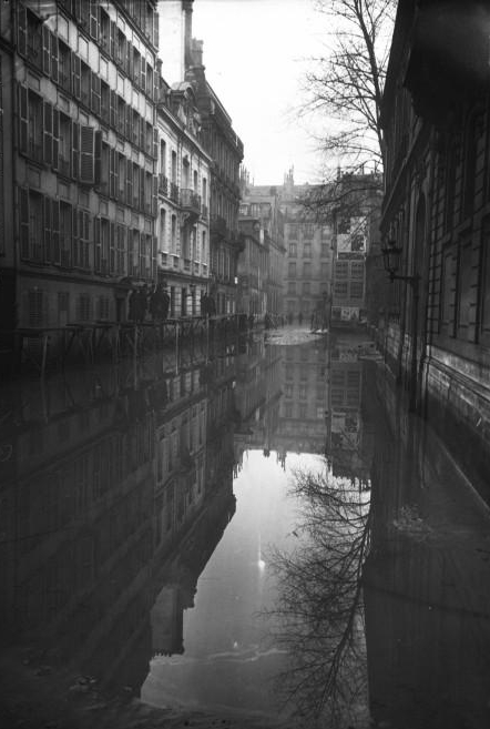
The cover photograph is useful for exactly that reason.[5] Rue de Poitiers is not shown as a sublime natural catastrophe. It is a normal street made unreadable: doors, windows, walls, and reflection all sit in the same vertical water column. The flood has turned the city section into evidence.
Saturated ground made the river a system problem
The first mechanism was accumulation. The Seine did not attack Paris as a sudden wave. Archives de Paris describes a wet summer, heavy winter precipitation, and saturated land upstream as the combined setting for the exceptional rise.[2] The National Assembly's historical account adds a more precise sequence: from January 15 to 20, 1910, Ile-de-France experienced very heavy precipitation on soils already saturated by a rainy autumn 1909.[3]
That slow buildup matters because it changed what counted as warning. A dramatic rupture concentrates attention. A slow flood makes decisions harder. The river rises, falls, rises again, fills low spaces, and tests every connection between surface and underground. By January 20, according to the National Assembly, boats could no longer pass under bridges and navigation on the Seine was suspended in Paris.[3] The problem had already moved from scenery to operations.
This is why the event should not be framed as a simple story of the Seine overtopping its banks. Archives de Paris stresses that in the capital water overflowed or emerged from below, then moved along quays and streets as far as the Gare Saint-Lazare area.[2] Modern Paris had made itself dense with conduits. In normal times, that density moved people, waste, power, messages, and goods. In the flood, it moved water.
Underground convenience became underground reach
The second mechanism was network reversal. Sewers, tunnels, basements, and service corridors normally make a city more efficient because they move messy or bulky functions out of sight. In 1910, that hidden city gave the flood more entrances.
Archives de Paris identifies the modern routes directly: the water used the recently opened underground and surface channels intended for transport and sewers.[2] The National Assembly's narrative shows how that translated into institutional failure. On January 21, the compressed-air plant in the 13th arrondissement that powered public clocks and elevators stopped working, and the pneumatic tubes used to send Chamber of Deputies records to the official journal became unusable.[3] This is not a colorful side note. It shows that the flood reached the city's timekeeping, vertical movement, and administrative communication systems.
The same sequence hit power and transit. During the flood, electricity installations were flooded; deprived of that source of energy, the Metro stopped, and horse-drawn omnibuses returned to service because tens of thousands of horses still existed in the capital.[3] The image is tempting as nostalgia, but the mechanism is modern. Electrical traction made the city faster; flooded electrical infrastructure made older transport suddenly relevant again. Redundancy came not from clever disaster design, but from leftovers of a previous urban era.
Government continuity became an improvised engineering problem
The third mechanism was political continuity under physical stress. The Palais Bourbon account shows how quickly a flood becomes a governance test. On January 23, the building's cellars were flooded. On January 24, the electrical installation in the basement that supplied the palace's lighting had to be abandoned after pumping efforts failed.[3] Access routes narrowed as nearby quays, parts of rue de l'Universite, and the Invalides esplanade went under water.[3]
The Chamber did not simply close. Deputies improvised lighting with oil lamps, candles, and benzol lamps; ventilation required an old steam machine; heating failed; and the building grew cold.[3] The Assembly continued to sit even as some deputies wanted adjournment and others feared that adjournment would alarm the public.[3] This is the political version of the same infrastructure story. A modern parliament depends on electricity, heating, ventilation, transport, documents, and communications. When those systems fail, constitutional continuity becomes material work.
The relief chain also became material. The Chamber voted an emergency credit of two million francs for people affected by the flood, and proposals followed about making municipal rooms available to those displaced.[3] By January 27, telephone and telegraph communications between parliamentary assemblies were interrupted, forcing an organized telegraphist service for message exchange.[3] The state did not disappear. It had to reassemble itself out of lamps, boats, coal, emergency credits, and workaround communications.
The flood made public health visible through infrastructure
The fourth mechanism was contamination risk. Floodwater is not only water. It is water after contact with streets, cellars, drains, fuel, refuse, and sewer systems. The National Assembly record says that on January 26 water rose in rue de Bourgogne because of sewer backflow.[3] The Palais Bourbon secretariat then warned residents of contamination danger from sewer water entering the building's conduits and urged them to use only boiled water for food and drink.[3]
That warning is historically important because it connects engineering to everyday behavior. The flood made risk travel through ordinary domestic acts: drinking, cooking, heating, sleeping, crossing a street, reaching work, obtaining food. The disaster was not only a spectacle one looked at from a bridge. It entered habits.
The modern City of Paris risk page still treats this as the right lesson. It explains that Paris floods are slow Seine floods, and that a 1910-type event takes on average 10 to 15 days to reach maximum level, with even longer recession possible.[4] It also warns that even homes outside mapped inundation zones may suffer flooded cellars or network outages such as electricity, gas, or heating cuts.[4] That is 1910's continuing logic: flood risk is not just a blue area on a map. It is also what happens to the networks a building depends on.
Post-flood planning turned memory into a planning category
The fifth mechanism was institutional learning. Archives de Paris says the January 1910 flood became the reference event for fighting this kind of natural disaster in Paris, not merely because of water height but because it struck a city whose modern infrastructure seemed to promise less vulnerability.[1] That is the crucial sentence in historical terms. The flood did not embarrass an archaic city. It embarrassed a modern one.
The official chronology gives the scale: December 1740 had already produced a major flood at 7.9 meters on the Pont de la Tournelle gauge, and 1910 reached about 8.6 meters at the episode's peak.[1] Archives de Paris then notes that in February 1910 a Commission des inondations was created to investigate causes and propose measures to prevent or reduce similar disasters.[1] The flood thus moved from event to administrative object within weeks.
That afterlife is one reason Jeffrey H. Jackson's history of the flood remains useful. Jackson frames the flood not only as water damage, but as a test of how a modern republican capital behaved under stress, drawing on the social and political response as much as the hydrology.[6] The point is not that Paris triumphed in some simple civic fable. It is that the flood forced the city to see modernity as a dependency chain. Streets, sewers, stations, deputies, hospitals, newspapers, workers, horses, police, engineers, and households were all part of the same urban organism.
The causal chain, then, is clear. A wet 1909 and heavy January 1910 precipitation saturated the basin. The Seine rose slowly enough to invite delay but high enough to stop navigation. Water then used underground systems to extend beyond the riverbank. Power, Metro service, pneumatic communication, rail access, heating, telephones, telegraphs, food supply, and drinking water became part of the disaster. The response required improvised mobility and emergency government. The aftermath converted the flood into a permanent risk reference.
That is why the 1910 flood still matters. It was not only a high-water mark. It was an audit of hidden interdependence. Paris learned that a city built for circulation can, under pressure, circulate the wrong thing.
Sources
- Archives de Paris, "La crue de 1910, une societe face aux risques" - official educational dossier on the 1910 flood as Paris's reference event, water heights, infrastructure vulnerability, and the February 1910 commission.
- Archives de Paris, "Les aspects de la crue de janvier 1910" - official account of weather, saturated soils, underground and surface pathways, affected arrondissements, streets, and economic paralysis.
- Assemblee nationale, "Janvier 1910 - Inondation du palais Bourbon - Crue de la Seine" - institutional chronology of precipitation, transport shutdowns, electricity, pneumatic tubes, parliamentary continuity, sewer backflow, emergency credits, and communications interruptions.
- Ville de Paris, "Que faire en cas de crue de la Seine a Paris ?" - current official flood-risk page explaining slow Seine floods, 1910-type timing, mapped inundation zones, cellar flooding, and network outage risks.
- Wikimedia Commons, "File:Paris 1910 Inondation rue de Poitiers.jpg" - source page for the January 1910 Agence Rol/Bibliotheque nationale de France press photograph used as the article image.
- Internet Archive, Jeffrey H. Jackson, Paris Under Water: How the City of Light Survived the Great Flood of 1910 (Palgrave Macmillan, 2010) - bibliographic page for the major scholarly monograph on the flood's social and urban history.