The old story of Angkor's end is tempting because it is clean. A great Khmer capital flourished in the forests of northwestern Cambodia, built enormous temples, depended on water, then collapsed when drought and invasion overwhelmed it. The ruins seem to invite that sentence. They make decline look like an abandoned stage.
The evidence has made the sentence harder to keep. Since the late twentieth century, archaeology, radar mapping, sediment studies, tree-ring climate reconstruction, and comparative urban history have pulled Angkor away from a one-cause collapse story. The better question is not whether climate mattered, or whether the water system mattered, or whether political power shifted. It is how those explanations fit together without making any one of them do all the work.[2][3][4][5][6]
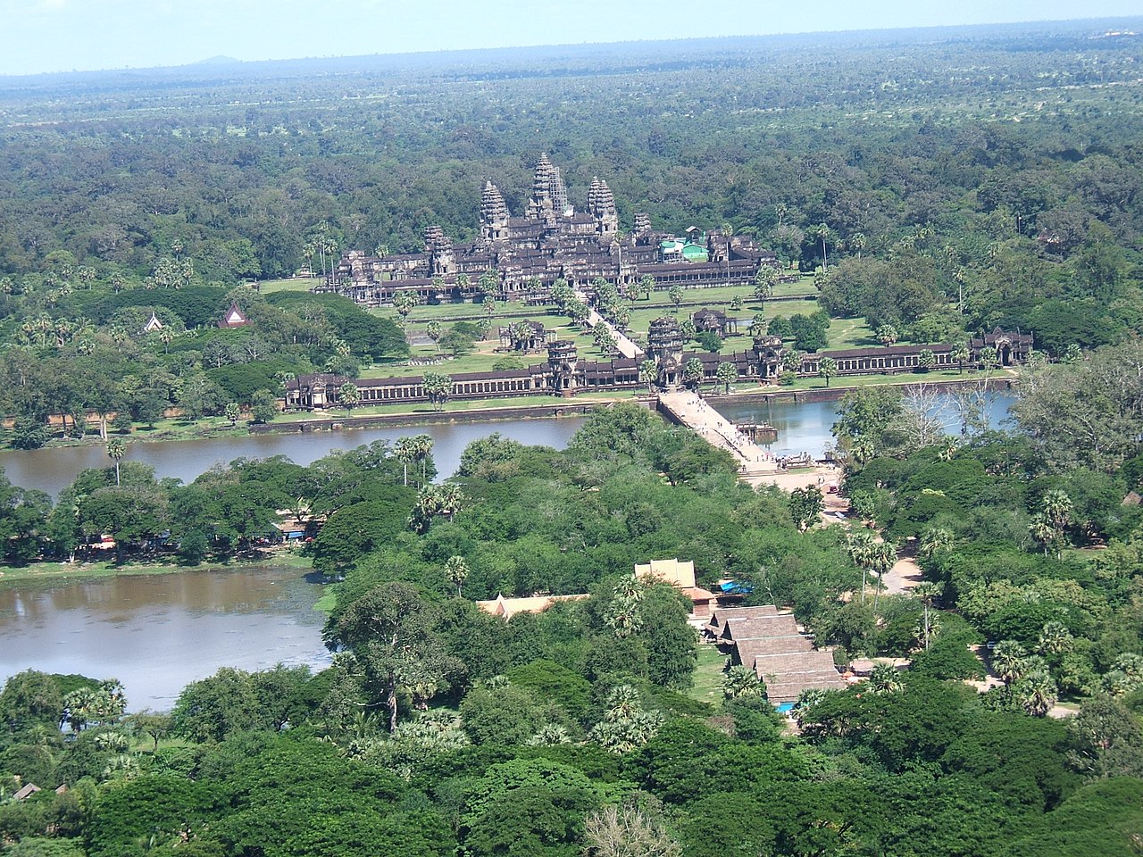
The timeline needs precision. Angkor rose as a Khmer imperial center from the ninth century and remained a major political and ritual landscape through the fifteenth century.[2][4] Angkor Wat itself belongs to the early twelfth century, but the city was never just that monument. By 1992, UNESCO inscribed Angkor as a World Heritage property of 40,100 hectares, a modern protection frame for a much older, wider landscape.[1] The historical debate sits between those scales: monumental temples on the one hand, low-density urbanism and infrastructure on the other.
Position 1: the hydraulic-city argument
The hydraulic-city interpretation says Angkor's power rested on water management. In this view, reservoirs, canals, moats, embankments, and roads were not decorative engineering around temples. They organized rice production, movement, settlement, ritual geography, and political authority. Fletcher, Penny, Evans, Pottier, and colleagues' 2008 study in Antiquity gives this position its modern archaeological spine by treating Angkor as a water-management network rather than as a group of isolated monuments.[3]
This argument gains force from scale. NASA's Earth Observatory summary of the 2007 mapping work explains that researchers used satellite imagery, aircraft radar, aerial photography, and ground observations over 2,848 square kilometers. The resulting picture placed dwellings and water tanks across roughly 1,000 square kilometers, linked by roads and canals, with Angkor's urban complex estimated at about 900 to 1,000 square kilometers.[2] That is not a temple compound with suburbs. It is an urban landscape spread thinly across water, fields, and infrastructure.
The hydraulic argument is strongest when it resists caricature. It does not have to claim that Angkor was a simple irrigation machine or that every canal served one purpose. It claims something subtler: once a polity ties authority, food supply, settlement, and ritual centers to a massive engineered landscape, the system's strengths and liabilities become historical actors. Water control made Angkor powerful. It also made Angkor hard to adjust quickly when conditions changed.[2][3]
Position 2: the climate-stress argument
The climate argument became sharper after Buckley and colleagues' 2010 PNAS study. Using tropical tree-ring evidence from southern Vietnam, the study reconstructed hydroclimate variability across roughly seven and a half centuries. Its key claim is not that one bad year destroyed Angkor. It is that the fourteenth and fifteenth centuries brought decades-long drought interrupted by unusually intense monsoon years, a pattern capable of stressing both water supply and water-control works.[4]
That distinction matters. Drought alone is too blunt a tool. A reservoir system can buffer dry years if storage, canals, and social organization remain functional. Flood alone is also too blunt. A well-maintained network can move excess water if its channels, spillways, and embankments still match the loads placed on them. Buckley's evidence becomes historically important because it identifies alternation: prolonged dry stress followed by damaging wet pulses.[4]
The climate position therefore explains timing better than it explains the whole event. It helps account for why a system that had endured for centuries faced exceptional pressure in the 1300s and 1400s. It does not by itself prove administrative breakdown, population movement, political fragmentation, or the end of royal authority. Climate supplies a forcing condition. The city still had to translate that stress into historical change.[4][5]
Position 3: the infrastructure-vulnerability argument
The infrastructure-vulnerability argument tries to connect the first two positions. Penny and colleagues' 2018 Science Advances paper models Angkor's water-distribution network as a complex system vulnerable to climatic variation. The point is not simply that waterworks can break. It is that large networks can distribute stress unevenly, concentrate failure at particular nodes, and become brittle when repeated shocks exceed repair capacity.[5]
This is where the debate becomes most useful. The water system's scale was not just an achievement to admire. NASA's account of the 2007 work notes evidence of impromptu changes, breaches, and failures within the water system, suggesting that waterways became harder to manage over time.[2] The 2018 model gives that observation a mechanism: a network can remain impressive in plan while losing resilience in operation.[5]
Read this way, Angkor's decline was not a single dramatic collapse but a maintenance crisis that became political. If a canal silts up, if a breach redirects flow, if a reservoir edge fails, or if one part of the network steals water from another, the problem is not only hydraulic. It is administrative. Someone must mobilize labor, allocate repair priorities, settle disputes, and preserve confidence that the center can still manage the landscape. Infrastructure failure becomes a test of state capacity.[2][5]
Position 4: the urban-diaspora argument
The urban-diaspora interpretation pushes back against the word "collapse" itself. Lucero, Fletcher, and Coningham's comparative essay argues that in tropical low-density agrarian urban systems, climatic instability helped destabilize political centers, but the outcome was not simply disappearance. Their term "urban diaspora" points to the breakdown of dispersed urban centers in favor of more compact communities in peripheral regions.[6]
This matters because Angkor did not become an empty ruin overnight. NASA's summary notes that some residents remained after the fifteenth century, even if only as a small remnant relative to the peak population.[2] The comparative argument asks historians to separate three processes that collapse language often merges: decline of a political center, transformation of settlement patterns, and continued life in the broader region.[6]
The diaspora reading also gives agency back to people who otherwise vanish inside systems language. If water management became unreliable and royal power less effective, households, specialists, monks, traders, farmers, and local elites still made choices. They could move, concentrate, adapt, attach themselves to different centers, or remain near sacred and economic nodes under changed conditions. The result may look like abandonment from the vantage point of a capital, but from the ground it may look like redistribution.[2][6]
Where the disagreement really sits
The strongest disagreement is not between "climate" and "human causes." Almost every serious interpretation now mixes both. The real disagreement is about sequence and weight.
One sequence begins with political and religious change, then treats water and climate as pressures on an already shifting system. Another begins with low-density urban form: Angkor's dispersed settlement and large water network created a maintenance load that became dangerous under climate volatility.[2][3][5] A third begins with climate, seeing the fourteenth- and fifteenth-century drought-monsoon cycle as the shock that exposed fragility.[4] The diaspora interpretation changes the endpoint, arguing that what collapsed was not civilization but a particular configuration of low-density political urbanism.[6]
These positions are compatible only if the story stays layered. The mapped city explains the scale of exposure.[2][3] The tree rings explain the unusual hydroclimate stress.[4] The network model explains how stress could travel through infrastructure.[5] The diaspora frame explains why the aftermath should not be mistaken for total disappearance.[6]
That layered interpretation also fits the visible landscape better. Angkor Wat's moat, causeways, and surrounding green plain are not proof of one thesis by themselves. They are reminders that Angkor was built as a relationship between monument, water, labor, fields, and movement. A drought-collapse story makes the city too passive. A pure political story makes the environment too incidental. A pure engineering story makes people too mechanical. The evidence points instead to a city whose strengths became harder to govern under changing water regimes.
So the most defensible answer is conditional. Angkor's transformation was probably not caused by drought alone. It was caused by the meeting of climate volatility, a huge and aging water landscape, political-administrative strain, and settlement redistribution. The capital did not simply fall because the rains failed. It changed because the system that once made rainfall governable became harder to repair, harder to coordinate, and less able to hold people, power, and water in the same shape.[2][4][5][6]
Sources
- UNESCO World Heritage Centre, "Angkor" - World Heritage inscription date, property size, criteria, and conservation frame for the Angkor site.
- NASA Earth Observatory, "Angkor, Cambodia" - summary of the 2007 remote-sensing study, mapped urban extent, water network, and evidence of water-system stress.
- Roland Fletcher et al., "The water management network of Angkor, Cambodia," Antiquity 82, 2008 - bibliographic record for the modern water-network interpretation.
- Brendan M. Buckley et al., "Climate as a contributing factor in the demise of Angkor, Cambodia," PNAS 107, 2010 - tree-ring climate reconstruction and drought/monsoon stress argument.
- Dan Penny et al., "The demise of Angkor: Systemic vulnerability of urban infrastructure to climatic variations," Science Advances 4, 2018 - network-vulnerability model for Angkor's water infrastructure.
- Lisa J. Lucero, Roland Fletcher, and Robin Coningham, "From 'collapse' to urban diaspora," Antiquity 89, 2015 - comparative argument reframing low-density urban breakdown as diaspora.
- Wikimedia Commons, "File:Angkor Wat aerial view (7294722974).jpg" - source page for the real aerial photograph used as the article image.