Willemstad is easy to flatten into color: pastel facades, blue water, cruise-port light, one quick bridge photo, done. The better local read is slower and stranger. Use the Queen Emma Bridge as an evening ritual, not as a shortcut. Cross from Punda to Otrobanda, wait if the bridge swings open, take the free ferry only if the harbor forces the issue, and let the interruption explain the city.
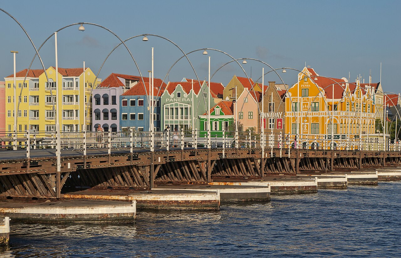
The scope is deliberately narrow: one bridge, two waterfronts, one working bay. Curacao's official tourism site gives the operating grammar in compact form. The Queen Emma Bridge was built in 1888 by Leonard Burlington Smith, connects Punda and Otrobanda, rests on 16 floating pontoon boats, and swings open with ship motors so vessels can enter the port.[1] That is the whole point. The bridge is not merely a heritage object laid across a pretty inlet. It is a civic hinge between walking city and maritime city.
Best window: arrive around 17:15-18:00, earlier if you want clean orientation and later if you only care about lights. Give the sequence 45-75 minutes. Start on the Punda side near Handelskade, cross once without rushing, turn back from Otrobanda to see the colored waterfront across the bay, then decide whether to linger for a bridge opening. Canadian Geographic's June 2026 field piece describes Willemstad through exactly this geography: St. Anna Bay cuts through the capital, Punda keeps the old waterfront lanes, and Otrobanda supplies the counter-bank with restored streets and street art.[6] The bridge is where those reads become one walk.
Local move one: do not start by chasing the perfect photograph. Stand on the Punda side long enough to understand the street pattern behind you. The official Willemstad heritage overview says the city covers 190 hectares around St. Anna Bay and includes four districts: Punda, Otrobanda, Pietermaai, and Scharloo.[2] It also notes that more than 700 buildings are protected monuments, about 50% of the inner city's building stock.[2] Carry those numbers lightly. They explain why the view feels dense even when the walking route is short.
Local move two: cross before you need to be somewhere. The bridge opens for harbor traffic, and that is not an inconvenience to optimize away. It is the city showing its priority order. UNESCO's statement of value is useful here because it calls Willemstad a historic port town whose districts grew around an active harbor and whose urban fabric still reflects more than three centuries of development.[3] If a ship interrupts you, the interruption is evidence.
Local move three: when the bridge begins to move, choose patience over performance. Stay clear of the working edge, let staff and regular walkers set the pace, and do not treat the closed gate as a photo line. Official tourism notes that when the bridge opens, pedestrians are carried across for free by the ponchi, the small ferry.[1] The practical choice is simple: if you are only out for the ritual, wait and watch; if you have dinner or a ferry connection, take the ferry and keep moving.
Local move four: use Otrobanda as the return view, not just the "other side." The name itself means other bank, but the district is not a backstage area. Curacao's heritage page describes Otrobanda as the second Willemstad district, west of St. Anna Bay, first developing with more spacious lots and later with denser working-class alleys.[2] That local texture matters. From Otrobanda, the famous Punda facades stop being a flat strip of color and become one side of a harbor relationship.
Local move five: walk the bridge at least twice if it stays closed. First crossing: look down at the wooden deck and pontoon rhythm. Second crossing: look sideways at the bay, the ferry movement, and the high Queen Juliana Bridge inland. The visitor mistake is to think one crossing is the experience. The local-style version is repetition: cross, pause, turn, cross again, let the same object behave differently as the light changes.
Local move six: keep spending optional. The crossing itself costs 0. The strongest version of the stop does not require a guided tour, a restaurant booking, or a paid viewpoint. A recent r/curacao local itinerary reply recommends a simple evening stroll through Punda and Otrobanda along the Queen Emma Bridge, noting that when the bridge is open you can use the ferry to cross between the two sides.[4] That advice is useful because it treats the bridge as ordinary city circulation with enough drama attached, not as a packaged attraction.
Local move seven: if you are coming from the cruise side, build in slack before you commit to a return crossing. Recent TripAdvisor review signals are unusually practical on this point: visitors repeatedly describe the bridge opening without a fixed tourist-friendly rhythm, the ferry as the fallback, and the night crossing as more memorable than a rushed daytime pass.[5] In practice, that means the table, taxi, or ship-return plan should follow the bridge, not the other way around.
Local move eight: let the bridge lights finish the route, but do not wait so late that the streets become your only memory. The ideal rhythm is early evening, first crossing, possible bridge opening, Otrobanda pause, second crossing, then a short waterfront sit. If cruise-ship timing or weekend crowds make the bridge feel congested, step off to the side and let the surge pass. The bridge is narrow enough in feeling that impatience spreads quickly; the better etiquette is to keep the crossing lane moving.
The trapline is predictable. Mistake one is using the bridge only as a photo prop from Handelskade. Better: cross it and feel the deck, because the point is movement. Mistake two is getting irritated when it opens. Better: treat the wait as the harbor's proof of life. Mistake three is assuming Punda has the whole view. Better: stand in Otrobanda and look back. Mistake four is overloading the same evening with every downtown museum, fort, mural, bar, and market. Better: give this bridge its own hour and let the wider city remain available for the next walk.
There is also a small social rule embedded in the old bridge story. From 1901 to 1934, official tourism notes, pedestrians paid a toll to cross except when they went barefoot.[1] The detail is charming, but it is more than trivia. It hints at the bridge's older life as a daily threshold between classes, errands, work, and weather. Today the crossing is free, the city is heavily photographed, and the waterfront is firmly on the visitor map. But the best version of the ritual still respects that older function: people need to get across.
That is why Queen Emma Bridge works better as an interruption than as a monument. It makes Willemstad legible because it refuses to separate beauty from use. The pastel harbor is real, but so are the ship motors, pontoons, ferry, waiting pedestrians, protected buildings, restored streets, and working bay. Give the bridge one unhurried evening hour and the city stops being a postcard. It becomes a moving hinge.
Sources
- Curacao Tourist Board, "Bridges" - official bridge overview covering the Queen Emma Bridge's 1888 origin, Punda-Otrobanda connection, 16 pontoons, swinging mechanism, former toll, and free ferry when the bridge opens.
- Curacao Tourist Board, "Willemstad: a vibrant UNESCO World Heritage site" - official heritage overview covering St. Anna Bay, the four districts, 190-hectare scale, protected monuments, and Punda/Otrobanda urban history.
- UNESCO World Heritage Centre, "Historic Area of Willemstad, Inner City and Harbour, Curacao" - statement of significance for the colonial port town, active harbor, four historic districts, integrity, and preservation pressures.
- Reddit
r/curacao, "Best things to do - short 2 day trip" - recent local/community itinerary advice recommending an evening stroll through Punda and Otrobanda along the Queen Emma Bridge and noting the ferry option when the bridge opens. - Tripadvisor, "Queen Emma Pontoon Bridge" - current visitor-review surface for night crossing, bridge-opening waits, free ferry fallback, and practical timing around the Punda-Otrobanda crossing.
- Canadian Geographic, "Crossing the floating bridge: Exploring Curacao's UNESCO capital" (2026-06-09) - recent reported travel feature confirming the bridge, St. Anna Bay, Punda, Otrobanda, and the UNESCO-city context.
- The Cosmonaut, "Queen Emma Bridge 2026-04-12.jpg," Wikimedia Commons - real photographic source used for the article image.