Utrecht is easy to flatten into the Dom Tower, a canal boat, and a shopping drift that could belong to half a dozen other Dutch centres. The city gets much sharper when you stop trying to "cover Utrecht" and instead read one layered seam properly. The useful seam is at the south end of the Oudegracht, where the canal, the wharf-level paths, and the turn into Twijnstraat all remain legible at once. Stay on the upper street first, go down to quay level only once, then use Twijnstraat as the sideways release.[1][2][3]
That sequence matters because Utrecht's canal is not merely scenic frontage. Discover Utrecht's local explainer says the Oudegracht was built in the 12th century to redirect the Oude Rijn and become an elongated harbour, with wharves and deep cellar spaces developing into a second street at water level.[1] The City of Utrecht's heritage brochure gives the longer time scale and the harder numbers: the Oudegracht was dug around 1000, Utrecht received its city charter in 1122, the wharf-cellar system took shape from the 12th and 13th centuries, and the canal still carries about 732 wharf cellars, roughly 4,100 metres of wharves, and 96 flights of steps down to the lower level.[2] That is the real Utrecht distinction. You are not looking at a normal canal edge. You are looking at a stacked city.
Twijnstraat is what keeps this from turning into pure heritage admiration. Discover Utrecht calls it one of the oldest shopping streets in Utrecht, set at the end of the Oudegracht inside the Museum Quarter, and notes that its specialty shops, boutiques, and restaurants make it a street many Utrecht residents actually use.[3] NLstreets sharpens the local tone: Twijnstraat is described there as Utrecht's oldest shopping street and even by its own traders as a "village in the city" where everyone knows each other.[4] That is why this south seam works better than a generic central stroll. The canal gives you structure; Twijnstraat gives you present-tense life.
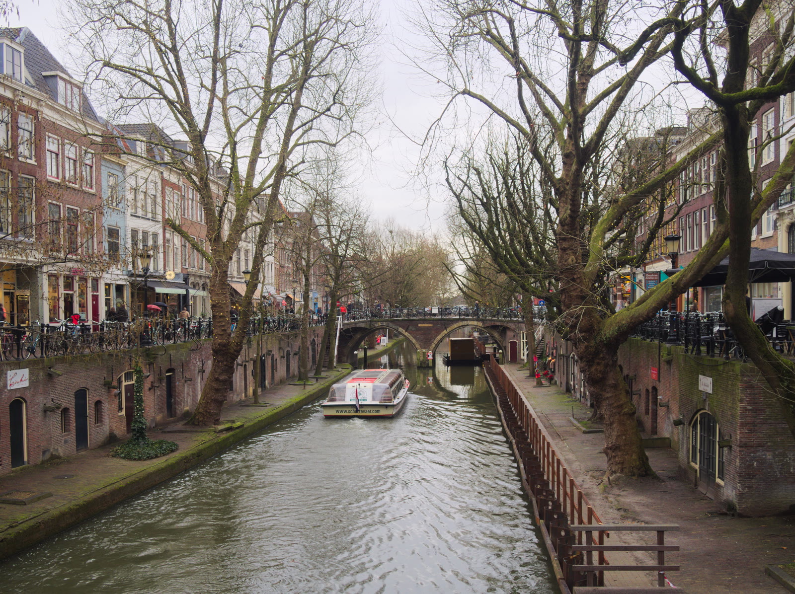
Image context: the cover uses a real documentary photograph of the Oudegracht with the lower wharf path, cellar doors, bridges, and a working boat all visible in one frame. That is the right recognition cue because the whole argument here depends on Utrecht being vertical in a quiet, practical way rather than monumental in a theatrical one.[8]
Why the south Oudegracht seam reads better than the chain-store core
Many first-time visitors reach Utrecht through the station side, drift past Hoog Catharijne, and then let the city centre sort itself out. The result is often a street sequence that gets busier before it gets more specific. Travel Life Balance's recent Utrecht piece is useful here because it names the transition plainly: Vredenburg turns into Lange Elisabethstraat, a very busy shopping street full of brand-name stores and restaurants, before you work your way into the older core.[7] That path is efficient, but it is not the cleanest first sentence for Utrecht.
The south Oudegracht and Twijnstraat seam is cleaner because it keeps the city's rare morphology and its local retail grain in the same frame. On one side you have the elongated harbour logic and the wharf cellars under the houses; on the other you have a street that still behaves like a neighbourhood strip rather than a retail funnel.[1][2][3][4] Even the practical notes support that reading. NLstreets lists every Sunday from 09:30 to 18:00 as Twijnstraat's shopping window, points drivers toward Vaartsche Rijn parking, and notes Line 2 as the local public-transport cue.[4] Those are not grand cultural facts. They are the small mechanics that tell you the street still functions for residents.
Why one descent to quay level is enough
The common tourist mistake on the Oudegracht is to over-romanticise the lower level. Once people discover the wharf stairs, they either stay above and never test the second street at all, or they descend and then try to make the entire outing happen at water level. Utrecht works better in one deliberate change of level.
The reason is that the canal is still an operating system. The municipality's current logistics page says electric supply boats move through the canals Monday to Saturday, departing from 2 locations, sailing the route twice per day, and carrying items such as beer, soft drinks, cooled products, and shop deliveries, with capacity for up to 42 roll containers and delivery both above and below the wharf.[5] The boating-rules page adds the complementary restraint: pleasure craft on Utrecht's waters are limited to 4.5 kilometres per hour, may carry at most 13 passengers, and are not allowed to stop in the Oudegracht even briefly for pickup, drop-off, or food.[6] Put those two pages together and the canal stops looking like a passive reflection surface. It becomes what it actually is: a working lower street with rules.
That is why one descent is the right amount. Go down once so the cellar doors, quay path, and waterline all become physical instead of abstract. Then come back up and let Twijnstraat handle the next chapter. If you stay below too long, the city flattens again, only this time from underneath.
Sunday is the oddly perfect day if you want local calm without dead air
Utrecht rarely gives you an obvious "best day" for a central walk, but this seam does. The reason comes from combining the street and canal sources rather than looking at either one alone. NLstreets says Twijnstraat trades on Sunday from 09:30 to 18:00.[4] The municipality says the canal-supply boats run Monday through Saturday.[5] Put together, those facts create a quietly excellent Sunday pattern: the shops and coffee places can still be alive while the freight rhythm on the Oudegracht takes a day off.
That does not mean weekdays are wrong. Weekdays are the version for people who want to see the wharf system doing what made it historically important in the first place: moving goods into the city below house level.[2][5] Sunday is simply the cleaner first visit for readers who want the south seam to feel inhabited without also having to read around logistics traffic.
8 local moves that make this Utrecht route land properly
- Approach the Oudegracht from above first. Utrecht's special trick is the stacked section, so begin on the upper street where you can understand the drop before you take it.[1][2]
- Use only one stair descent to quay level. The lower path matters most as a change of perspective, not as the entire route.[2]
- Let Twijnstraat be the lateral move, not an afterthought. It is one of the oldest shopping streets in Utrecht and sits exactly where the canal seam needs a second texture.[3][4]
- Choose Sunday if you want the calmest first read of the area. Twijnstraat is open 09:30-18:00 on Sundays, while the freight boats operate Monday-Saturday.[4][5]
- Choose a weekday if you want to see the canal behaving like infrastructure. The municipality still runs the water-distribution system twice daily and serves businesses both above and below the wharf.[5]
- Do not plan a pleasure-boat stop as part of this outing. On the Oudegracht, boats may not stop even briefly, and the speed cap is 4.5 km/h.[6]
- If you are arriving by car or tram-bus logic, use the Twijnstraat practical cues instead of improvising. NLstreets points to Vaartsche Rijn parking and Line 2 as the clean access pair.[4]
- Keep your eye on the old service geometry, not only on cafe tables. The cellar doors, steps, and split levels are the whole point; the fact that there are 732 wharf cellars and 96 stair flights should change how you look.[2]
Non-local trapline
Mistake 1: entering Utrecht through the busiest brand-store corridor and assuming that is the city's real shopping texture
Better move: let the south Oudegracht/Twijnstraat seam do the first introduction. It keeps the local street grain and the canal morphology together instead of separating them.[3][4][7]
Mistake 2: treating the Oudegracht as a canal-view backdrop without ever changing levels
Better move: descend once and make the lower street tangible. Utrecht's distinctiveness is structural, not decorative.[1][2]
Mistake 3: trying to spend the whole outing at wharf level
Better move: read the lower level as one chapter, then come back up. The area lands best when the canal and Twijnstraat answer each other.[2][3]
Mistake 4: assuming a pleasure boat can solve your navigation
Better move: walk it. The municipality's own boating rules make clear that the Oudegracht is tightly managed, slow, and unsuitable for casual stop-start sightseeing logic.[6]
Concrete go details
- Best window: Sunday from about 10:30 a.m. to early afternoon if you want Twijnstraat active while the freight boats are off the canal; choose a weekday if you specifically want to see the lower-level logistics still working.[4][5]
- Expected spend: EUR0 if you simply walk the seam. The value here is urban structure, not ticketed access.[1][3]
- Queue and reservation reality: none for the walk; the main constraints in this area are movement rules on the water, not entry gates on land.[5][6]
- Where to stand: take your longest pause at an upper-level bridge, then one pause at wharf level, then a final slower drift along Twijnstraat where the old facades and everyday shopfronts pull the route back into street life.[2][3][4]
- Navigation cue:
south Oudegracht upper street -> one stair descent to the wharf path -> next rise back to street level -> Twijnstraat -> return to the canal once more only after the street has done its work.[1][3][4] - Numeric anchors worth keeping: 1000, 1122, 12th century, 13th century, 732 wharf cellars, 4,100 metres of wharves, 96 stair flights, 09:30-18:00, Monday-Saturday, 2 locations, twice per day, 42 roll containers, 4.5 km/h, 13 passengers.[2][4][5][6]
Utrecht has grander icons than this and louder streets than this. Very little explains the city more efficiently. One stacked canal, one chosen stair, one old shopping street at the edge of it: that is enough to make Utrecht stop behaving like a postcard and start behaving like a place.
Sources
- Discover Utrecht, "Canals and shipyards" (official tourism page covering the Oudegracht as a 12th-century elongated harbour and explaining the wharves, wharf cellars, and water-level second street).
- City of Utrecht / Erfgoed Utrecht, "Bustling Wharves" (official heritage brochure covering the Oudegracht's c. 1000 origins, the 1122 city charter, and the statistics of 732 wharf cellars, c. 4,100 metres of wharves, and 96 stair flights).
- Discover Utrecht, "Twijnstraat" (official tourism page describing Twijnstraat as one of Utrecht's oldest shopping streets at the end of the Oudegracht and noting its specialty-shop, boutique, and restaurant mix).
- NLstreets, "Twijnstraat" (local shopping guide describing Twijnstraat as Utrecht's oldest shopping street, quoting the traders' "village in the city" self-image, and listing Sunday hours, Vaartsche Rijn parking, and Line 2 access).
- Gemeente Utrecht, "Goederenvervoer over water" (official municipality page covering the electric supply boats that run Monday-Saturday from 2 locations, sail twice daily, and deliver above and below the wharf with capacity up to 42 roll containers).
- Gemeente Utrecht, "Recreatievaart (plezierboten)" (official municipality page covering the 4.5 km/h speed limit, the no-stopping rule on the Oudegracht, and the 13-passenger maximum for pleasure craft).
- Travel Life Balance, "Why Locals Call Utrecht One of the Most Beautiful Dutch Cities" (travel guide updated 2 June 2025; useful here for the distinction between the busy Vredenburg/Lange Elisabethstraat shopping corridor and the older scenic core).
- Wikimedia Commons, "File:Oudegracht 7103.jpg" (documentary cover photograph source).