San Francisco gives you many Golden Gate views, but not every bridge hour is worth the same amount. The high-yield spring version is tight and time-aware: Fort Point first, Veterans Overlook second. One anchor puts you under the south anchorage at water level, inside a fort begun in 1853 during the Gold Rush; the other puts you back above grade at Presidio Tunnel Tops, the 2022 parkland stitched over the old Presidio Parkway tunnels.[2][3] The result is not a generic "see the bridge" program. It is a short local sequence for the hours when the span is still clean enough to read before wind, fog, or flat light take the edges away.
That timing matters more here than visitors usually expect. Fort Point has a real operating clock: the fort is open Thursday through Monday, 10:00 a.m.-5:00 p.m., with roof access ending at 4:30 p.m., while the exterior stays accessible 7 days a week.[1] Presidio Tunnel Tops runs on the opposite logic: it is free, outdoors, and open daily like the rest of the park, with restrooms at Presidio Transit Center and near the Outpost.[3] Put those two clocks together and the clean move becomes obvious. Use Fort Point while it is still open, then let the later light belong to the overlook.
San Francisco's own local behavior backs this up. The Presidio tells you to bring extra layers even for a short scenic route, and the Visitor Center's insider tip is almost comically direct: if the fog catches you off guard, buy a sweatshirt.[4][5] In a recent r/AskSF thread, one local said the Golden Gate "was in fog or rainy more often than not," then still recommended walking Tunnel Tops in the rain; another local answered a "where do you go to clear your mind?" question with the red Adirondack chairs at Tunnel Tops.[6][7] That is the city's real cue. Do not wait for some perfect postcard certainty. Use the clear window when you get it, and know where the second stop should be.
Why this two-anchor spring window works better than a single bridge stop
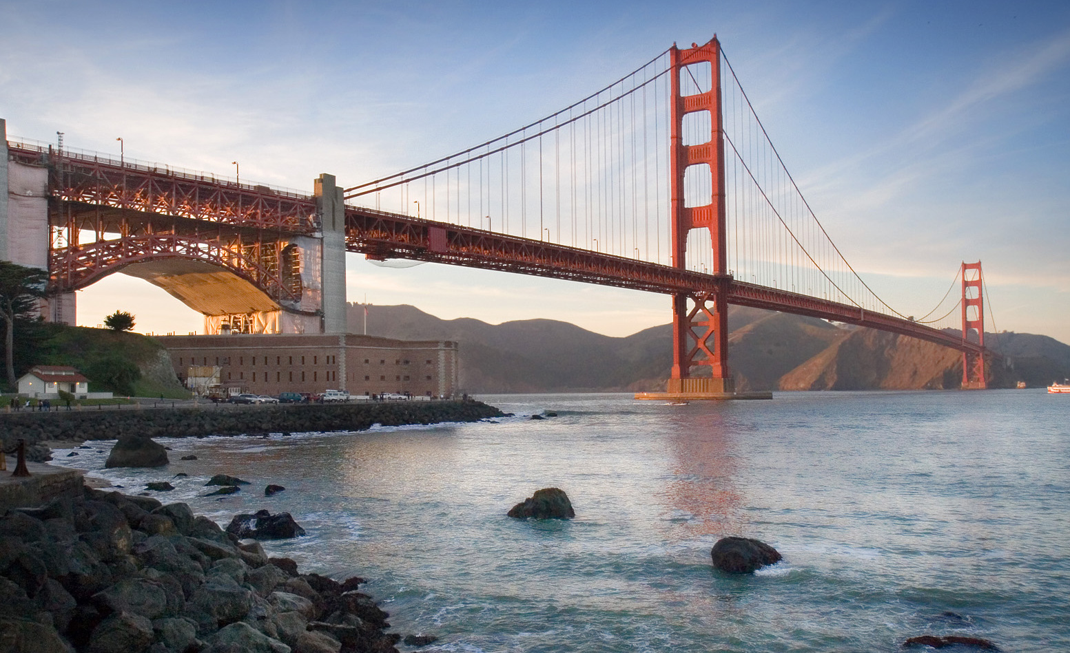
Fort Point gives you scale the tourist pullouts do not. At the end of Marine Drive, under the bridge's southern approach, you stand close enough to feel how over-engineered the place is: military brick, wind, bridge steel, wave noise, and the whole bay mouth compressing through a narrow gate.[1][2] If you start at Tunnel Tops, the bridge can look like a distant symbol. If you start at Fort Point, it first lands as structure and exposure.
Veterans Overlook gives you the right second read. The Presidio's own accessible itinerary treats it as the western payoff along the Cliff Walk at Tunnel Tops, after Bay Overlook and Crossroads Overlook. There the bridge comes back into frame with a quieter foreground: reclaimed cypress benches, the slope of Golden Gate Meadow, and San Francisco National Cemetery just to the southwest, where 30,000 military veterans are buried.[4] That combination matters because it cools the outing down. Fort Point is the hard-edged entrance. Veterans Overlook is the pause that makes the bridge feel civic rather than merely scenic.
The seasonal part is not flowers or an event calendar. It is the spring logic of borrowed clarity. On a bright afternoon, get the fort first while the interior is open, then move up before the later wind and softer light flatten the bridge out. If the weather turns anyway, the route still holds because the Presidio built in its own fallback: the Visitor Center, the transit pavilion, and a park culture that assumes jackets, not heroic optimism.[3][5][6]
Anchor 1: Fort Point should be your timing gate, not your whole day
Treat Fort Point as the route's opening chamber and its strictest clock. The NPS hours page is unambiguous: 10:00 a.m.-5:00 p.m., roof access ending at 4:30 p.m., closed Tuesday and Wednesday inside the fort, but the exterior accessible every day.[1] That means two valid versions exist. The best version hits the interior and roof before 4:30. The fallback version still works from the outside wall and road edge, especially if what you wanted most was the bridge sitting directly on top of the masonry.
The fort is also free.[1] That matters because it keeps the first anchor light. You are not building around a ticket, only around the closing clock. The Presidio's Fort Point page adds the useful approach detail: if you are coming from bridge-plaza level, you reach the fort by taking the steps down to the Battery East trailhead and following the road.[2] Read that in reverse when you leave. The clean exit is upward, not back into parking-lot indecision.
Place-specific texture is doing real work here. Fort Point was begun in 1853, served through the Civil War and again in World War II, and later survived to become a National Park site in 1970.[2] The building is older than the bridge above it and older than most of the city visitors think they are reading when they say they came for a bridge view. That is why the route improves when you start here. The Golden Gate first appears as infrastructure layered over older defense logic, not as an isolated icon.
Anchor 2: Veterans Overlook is the right second room at Tunnel Tops
Do not make Presidio Tunnel Tops the second anchor in the abstract. Make it Veterans Overlook specifically. The Presidio's short accessible itinerary lays out the sequence: Bay Overlook, Crossroads Overlook, then Veterans Overlook, where the path passes curvy cypress benches and opens to another Golden Gate vista.[4] That last overlook is the correct stopping point because it faces the bridge while also tipping your eye toward the cemetery and meadow. The bridge is still the subject, but it is no longer the only one.
This is also where the local body language changes. The local comment about the red Adirondack chairs is not trivial.[7] It tells you how people actually use the place. They do not only photograph and move on. They sit, clear their head, and let the view do less work. That is the move worth stealing. Veterans Overlook is not the place for a frantic final photo sprint. It is the place for one longer pause after Fort Point has already given you the hard geometry.
The Presidio route notes also solve the small mechanics. The scenic path is only 0.3 miles end to end and the park suggests 2 hours for the whole sequence with stops, plus extra layers.[4] The larger Tunnel Tops page confirms the site is free, open daily, and has restrooms at Presidio Transit Center and near the Outpost.[3] So the second anchor has almost no friction besides weather and your own pacing.
8 local moves that make this bridge window actually work
First, get to Fort Point by about 3:30-4:00 p.m. if you want the roof. That keeps you inside the fort before the 4:30 p.m. roof cutoff.[1]
Second, keep Tuesday and Wednesday as exterior-only days instead of forcing the fort to be something it is not. The outside still works because the exterior is accessible 7 days a week.[1]
Third, use Fort Point as the first stop only. Once the fort has done its job, climb out by the Battery East route and carry the bridge uphill rather than lingering until the second anchor becomes an afterthought.[2]
Fourth, bring extra layers even on bright spring afternoons. The Presidio's own itinerary tells you to, and the Visitor Center's fog-sweatshirt tip is basically a local weather philosophy in one sentence.[4][5]
Fifth, at Tunnel Tops, walk past the first broad lawns and commit to Veterans Overlook. The more memorable pause is farther west, not at the first available patch of grass.[4]
Sixth, use the red-chair logic. If a chair is open, take it. The local point of the overlook is not only to stand and shoot, but to sit and let the bridge settle into your peripheral vision.[7]
Seventh, treat the whole route as a $0 run unless you choose to drive. Fort Point is free, Tunnel Tops is free, and the only built-in cost is paid parking if you bring a car.[1][3]
Eighth, if the weather turns halfway through, do not scrap the second anchor. Locals still tell people to walk Tunnel Tops in the rain; the route only fails if you expect the bridge to look static all afternoon.[6]
Non-local trapline: 4 common mistakes and the better move
Mistake 1: starting at Tunnel Tops because it feels easier
Better move: start at Fort Point. The fort has the tighter clock, and the bridge reads better after you have already seen it from underneath.[1][2]
Mistake 2: drifting through Fort Point until the roof closes
Better move: make one strong pass, hit the roof before 4:30 p.m., and leave while the second anchor can still take the late light.[1]
Mistake 3: treating Tunnel Tops as one generic picnic lawn
Better move: stay with the overlook sequence and stop at Veterans Overlook, where the bridge, meadow, and cemetery finally balance each other.[4]
Mistake 4: dressing for an inland spring city
Better move: bring the extra layer first and call it insurance, not overpacking. The Presidio and locals are both telling you the same thing about fog and wind.[4][5][6]
Concrete go details
- Best window: on clear spring afternoons, aim to reach Fort Point around 3:30-4:00 p.m., clear the roof before 4:30 p.m., and let the second half belong to Veterans Overlook from roughly 4:45-6:15 p.m. if visibility holds.[1][4]
- Expected spend: $0 on the core route if you arrive by transit, shuttle, bike, or on foot; paid parking is the only routine added cost.[1][3]
- Queue and reservation reality: no ticketing and no reservations for the core route. The real friction is weather timing and parking choice.[1][3]
- Where to stand or sit: Fort Point roof if it is open, exterior wall if it is not; at Tunnel Tops, skip the first lawns and take one of the seats at Veterans Overlook.[1][4][7]
- Navigation cue:
Marine Drive / Fort Point -> Battery East trail climb -> bridge-plaza level -> east along Presidio Tunnel Tops paths -> Veterans Overlook.[2][4] - Numeric anchors worth keeping: 1853, 1970, 2022, 10:00 a.m.-5:00 p.m., 4:30 p.m., 7 days, 0.3 miles, 2 hours, 30,000 veterans.[1][2][3][4]
San Francisco has more famous bridge postcards than this route. It does not have many better two-stop sequences for reading how the city actually works. Fort Point gives you the bridge as structure and exposure. Veterans Overlook gives it back to you as weather, park habit, and civic memory. Put them together inside one borrowed clear window and the Golden Gate stops being a logo for about ninety minutes.
Sources
- National Park Service, "Operating Hours & Seasons - Fort Point National Historic Site" (Thursday-Monday 10:00 a.m.-5:00 p.m.; roof access closes 4:30 p.m.; exterior accessible 7 days a week; updated 2025-06-24).
- The Presidio, "Fort Point National Historic Site" (1853 construction start, Civil War/World War II use, National Park status in 1970, Battery East access, transit and parking cues).
- The Presidio, "Presidio Tunnel Tops" (free daily access, waterfront connection, transit, parking, restrooms, and weather-related outdoor rules).
- The Presidio, "Golden Gate Bridge Views with a Presidio Picnic" (0.3-mile accessible overlook route, 2-hour timing, extra-layers note, Veterans Overlook sequence, 30,000-veteran cemetery cue, and red-chair overlook photo).
- The Presidio, "Presidio Visitor Center" (open daily 10 a.m.-5 p.m.; maps, weather updates, and the insider tip about buying a sweatshirt if fog catches you off guard).
- Reddit / r/AskSF, "How do i make the most out of my SF trip" (local comment noting the bridge is fogged or rainy more often than visitors expect, and still recommending a Tunnel Tops walk; accessed 2026-04-09).
- Reddit / r/AskSF, "Where do you go to clear your mind?" (local recommendation for the red Adirondack chairs at Tunnel Tops; accessed 2026-04-09).
- Google Maps community listing, "Fort Point National Historic Site."
- Google Maps community listing, "Presidio Tunnel Tops."
- Wikimedia Commons, "File:GG-ftpoint-bridge-2 (cropped).jpg" (documentary photograph used for the cover image).