The useful way to ride Quito's TelefériQo is to stop treating it as a shortcut to a photograph. Make it a high-window ritual: leave the city while the morning is still workable, rise from the western edge of Quito toward Cruz Loma, pause before walking, and let the thinner air decide the pace. The point is not to "do" the cable car quickly. The point is to feel Quito change from street grid to volcanic shoulder in about one cabin ride.[1][3]
That shift is sharp because the altitude change is not decorative. The official TelefériQo site frames the ride as an 18-minute journey to the Cruz Loma side of the mountain, and its hiking page places the walking area at more than 4,000 meters above sea level.[1][2] QuitoTrip's current visitor guide gives the practical scale in one line: roughly 2,950 meters at the base station, 4,050 meters at Cruz Loma, and about 1,100 meters of gain in around 20 minutes.[3] Even if those numbers vary slightly by source and exact measuring point, the travel lesson is stable: this is a fast vertical transfer, not just a scenic lift.
The local move is therefore restraint. A recent r/Quito hiking thread is useful less for a definitive safety rule than for its tone: people discuss the TelefériQo as a gateway to mountain walks and immediately shift into questions about going alone, groups, clubs, and access conditions.[5] Tripadvisor's 2026 review page is similarly practical in aggregate, with recent comments emphasizing the views while also warning that the top can be cold.[4] Read those signals together and the visitor mistake becomes obvious: the top station is not a theme-park balcony. It is an exposed high place attached to a real mountain.
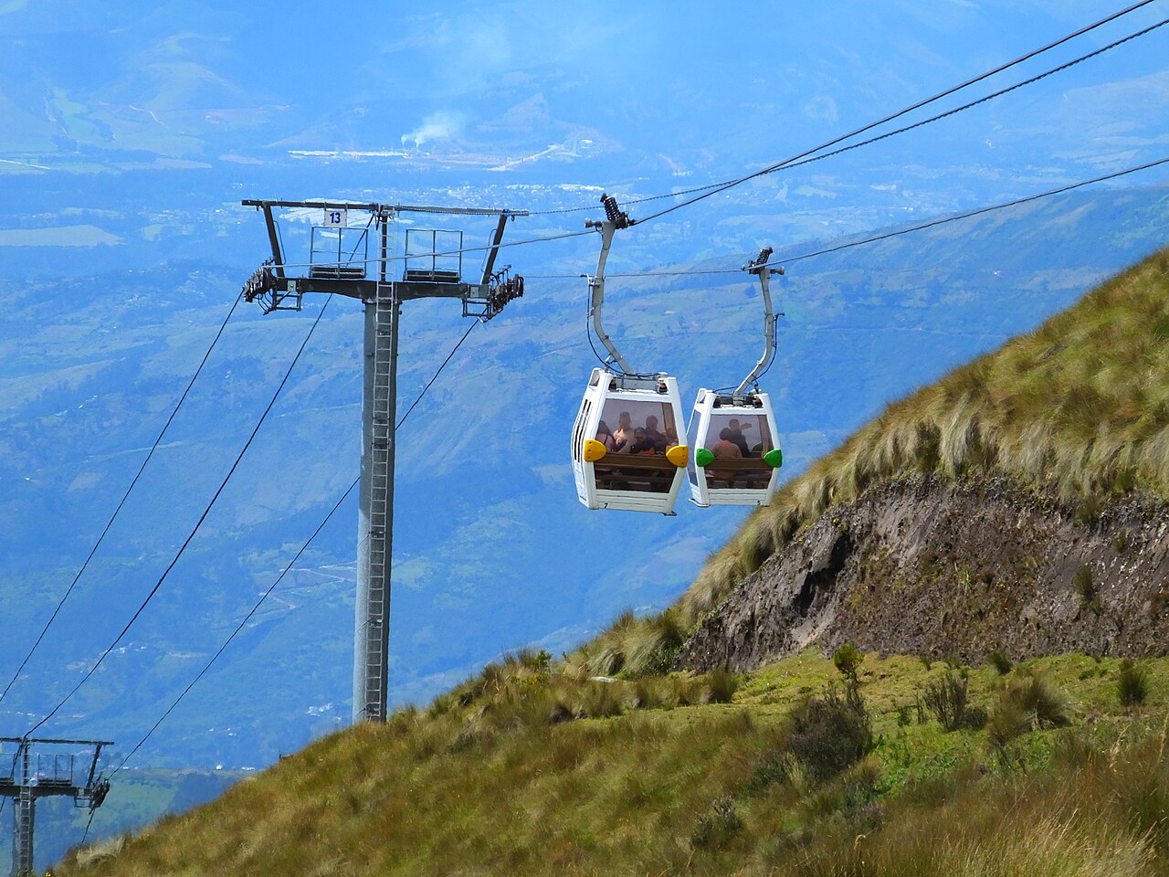
Image context: the cover uses AndrewDressel's 2017 Wikimedia Commons photograph of TelefériQo gondolas above Quito. It is a direct documentary photograph of the transport object and mountain setting discussed here, which is why it fits this post better than a diagram, stock travel image, or distant skyline.[6]
Start With The Weather, Not The Ticket
Begin by checking clouds before you commit. Cruz Loma can be clear while the city is still waking, then turn into a white room by late morning or early afternoon. The official site stresses the view from multiple miradores and the 18-minute descent note on its schedule-and-fares page; the hiking page warns that weather can change suddenly and recommends a windbreaker, grippy shoes, comfortable clothing, and protection against rain and cold wind.[1][2] That is not generic packing advice. It is the operating manual for the visit.
The best window is 08:30-10:30 if the morning is clear. Go later only if the sky is still open and you are comfortable making the ride mostly for atmosphere rather than volcano views. Build the outing as a 2.5- to 4-hour city move: taxi or ride-hail to the base, ticket and cabin up, a slow first loop around the mirador area, optional short walking toward the marked paths, then a return before weather or closing pressure turns the descent into a negotiation.[1][2][3]
Expected spend should stay modest but flexible. QuitoTrip lists $8.50 for adults and $6.50 for children as a current round-trip ticket reference, while the official TelefériQo page should be checked before you go because operating hours and fares are the live authority.[1][3] Add the road transfer from your hotel or the nearest practical meeting point. This is not a place to economize by adding a confusing long walk to the base at the start; save your legs for the altitude.
Let Cruz Loma Slow You Down
When the cabin doors open, do not chase the first hill. Stand still for a minute. The top station sits high enough that the normal visitor's body needs a reset: breath shortens, slopes feel steeper than they look, and a small rush can turn a pleasant viewpoint into a headache. The official hiking page explicitly marks the area as above 4,000 meters and suggests 11:00 as the maximum recommended time to start for the Rucu Pichincha summit from Cruz Loma.[2] For this route, that summit hike is not the assignment. The assignment is to borrow the mountain's edge without pretending you came prepared for a mountaineering day.
The short version is enough: walk to the mirador, look back at Quito's long north-south form, watch the cloud line, and decide whether the next ten minutes should be uphill, level, or back toward coffee and the return station. QuitoTrip frames clear mornings as the moment when Cotopaxi, Cayambe, and other Andean peaks may appear beyond the city.[3] Treat that as a bonus, not a promise. The better rhythm is to let the view arrive in layers: city basin first, Pichincha slope second, distant volcanoes only if the weather grants them.
There is a cultural reason this works. Quito is often sold through its colonial center, churches, plazas, and equatorial excursions, but the city also lives under immediate vertical pressure. The TelefériQo makes that geography legible in one movement: traffic and neighborhoods fall away, the páramo edge appears, and the city below stops looking like a flat map. That recognition is the real payoff. It changes how the streets feel when you come back down.
Local Moves That Change The Ride
First, go on a clear morning rather than a free afternoon. The cable car is weather-led; do not treat it as a filler activity after lunch.[1][2][3]
Second, use a direct road transfer to the base. The attraction starts with the cabin, not with arriving tired, rushed, or unsure at the lower station.
Third, bring a jacket even when Quito feels mild below. Official hiking guidance calls out cold wind and sudden rain, and recent traveler reviews keep repeating that the top is colder than expected.[2][4]
Fourth, walk slowly for the first ten minutes at Cruz Loma. The altitude gain happens too fast for bravado to be useful.[2][3]
Fifth, make the viewpoint loop the default plan and the Rucu Pichincha trail the exception. The official hiking page's 11:00 summit-start guidance is a boundary marker: if you did not plan a hike, do not improvise one.[2]
Sixth, keep the ticket, schedule, and return descent in mind before wandering away from the station. TelefériQo's own page reminds visitors that the cabin descent takes around 18 minutes and that they need to be at the return station in time.[1]
Seventh, watch the clouds behind you, not only the city below. The view can close quickly, and the descent is calmer when you leave before everyone else has the same idea.[1][2]
Eighth, turn the ride into a city-reading exercise. On the way down, look for how Quito stretches along the valley; that shape will make later taxi rides, viewpoints, and neighborhood choices easier to understand.[3]
Non-Local Trapline
Mistake 1: treating the TelefériQo as only a selfie platform. The better alternative is to use the cabin as a paced transition from city to mountain, then spend enough time at Cruz Loma for your body and eye to adjust.[2][3]
Mistake 2: arriving without warm layers because the city below feels comfortable. The better alternative is to pack for wind, cold, and possible rain before leaving the hotel. The official hiking guidance is explicit about sudden weather changes.[2]
Mistake 3: deciding at the top that Rucu Pichincha sounds fun. The better alternative is to separate a viewpoint visit from a real hike. If the summit is the goal, start early, use proper gear, and treat the 11:00 guidance as a latest-start warning, not a suggestion to begin thinking about it.[2][5]
Mistake 4: pushing the visit until the final comfortable descent window. The better alternative is to leave while the return still feels boring. The official note about the 18-minute descent is exactly the sort of small operational detail that saves the day from ending in a queue or weather scramble.[1]
Concrete Go Details
Best time window: 08:30-10:30 on a clear morning, with flexibility only if cloud cover is already part of the experience you want.[1][2][3]
Route shape: hotel or central pickup -> TelefériQo base station -> 18- to 20-minute cabin ride -> Cruz Loma mirador loop -> optional short signed walk -> return station -> cabin descent -> road transfer back.[1][2][3]
Expected spend: use $8.50 adult / $6.50 child as a recent public reference for the round-trip cable car, then verify live pricing on the official page before going and add your road transfer budget.[1][3]
Queue and reservation reality: the article's safer assumption is no elaborate reservation plan and no last-minute heroics; arrive early, buy at the base, and leave yourself enough return margin for clouds, lines, or slow walking.[1][2][4]
Where to stand or sit: in the cabin, take the city-facing side on the way up if available; at the top, step aside before stopping for photos so the path keeps moving.
Navigation cue: if you are above 4,000 meters, moving slowly, and still close enough to see the return station, you are using the TelefériQo well. If you are breathless, far from the station, and only then checking the weather, you have turned a city ritual into an avoidable mountain problem.[1][2][3]
Sources
- TelefériQo Quito, "Tarifas y horarios" - official operating page, including return-descent timing note.
- TelefériQo Quito, "Senderismo" - official hiking guidance for Cruz Loma, altitude, weather, clothing, and Rucu Pichincha start-time boundary.
- QuitoTrip, "Quito Cable Car: Best Views at 4,050m - Essential Guide" - visitor logistics, altitude references, ride duration, and ticket-price reference.
- Tripadvisor, "TelefériQo Quito" - traveler review page with recent 2026-facing review context and practical visitor comments.
- r/Quito, "Senderismo alrededor de Quito" - recent community discussion on mountain walking around Quito and the TelefériQo as an access point.
- AndrewDressel, "Gondolas of the TeleferiQo in Quito, Ecuador" - Wikimedia Commons photographic source for the cover image.