The easy Portland mistake is to treat the Aerial Tram as a four-minute stunt, then leave South Waterfront with no clearer idea of how the city is stitched together. The better move is tighter and more local: start at SW Moody & Gibbs, ride the tram up and back outside commute windows, then immediately walk the Gibbs Street Pedestrian Bridge so the hill, the freeway cut, and the river-edge district resolve into one short urban section.[1][2][3][6] This is not a generic viewpoint outing. It is a small infrastructure read.
The official rules already tell you why timing matters. Portland Aerial Tram says public fare is a $8.75 same-day round trip, bought online or onsite by credit or debit card at either terminal; all people boarding must have fare; children 6 and younger ride free with a fare-paying adult; and Hop or other transit passes do not count as tram fare.[1] The hours page says the tram runs 5:30 a.m.-9:30 p.m. on weekdays, 9 a.m.-5 p.m. on Saturdays, and stays closed on Sundays, while nearby streets and the cabins themselves are typically crowded on weekdays from 7-9 a.m. and 4-6 p.m.; the same page explicitly recommends 10 a.m.-3 p.m. or 6-9 p.m. on weekdays if you want a calmer ride.[2] That is already enough to separate a good visit from a bad one.
What makes this seam specifically Portland is not just the elevation change. Travel Portland's updated guide frames the tram as a commuter conveyance that has also become a sightseeing tool, rising 500 feet above South Waterfront and covering 3,300 linear feet between the lower terminal and Marquam Hill.[5] The same guide says cabins depart about every 5 minutes, take 4 minutes one way, carry 79 people, and move roughly 10,000 weekday passengers through the system.[5] The tram's own rider guide adds two practical details visitors should respect: the cabin swings slightly at the tower, so first-time riders should hold a rail, and if you care about a particular window position, waiting five minutes for the next cabin is often smarter than boarding the first crowded one.[4]
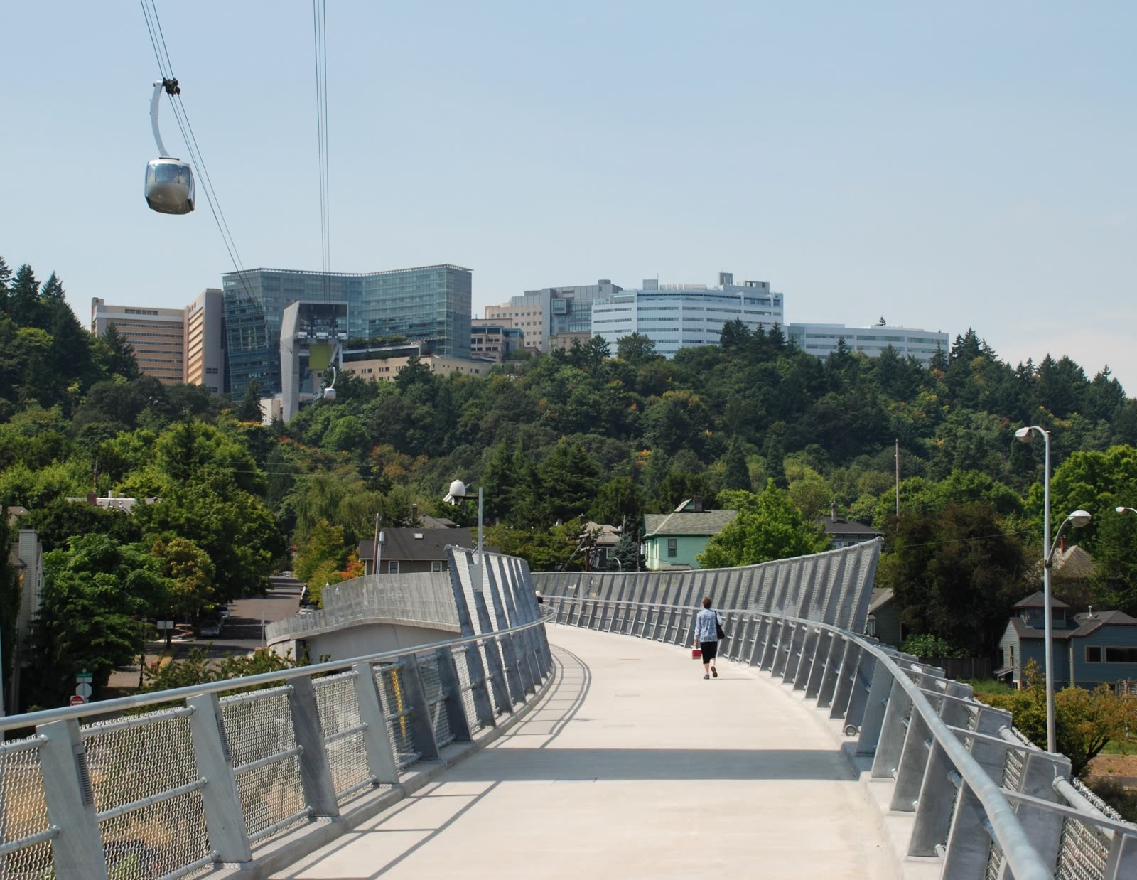
The bridge is what keeps this from collapsing into a postcard ride. Portland's own bridge-design policy says Interstate 5 created a physical barrier between Lair Hill and the Willamette River, and that the Gibbs Street bridge was intended as a needed bicycle-and-pedestrian link between southwest neighborhoods and the waterfront.[6] Read that alongside the directions page, which routes bus lines 19, 43, 44, and 66 to the tram area via the Hooley bridge at Gibbs Street, and the district stops feeling accidental.[3] Even the accessibility layer matters here: PBOT's current elevator-status page lists the Gibbs Street bridge elevator as in service, which is exactly the sort of tiny operational fact that changes whether this route is genuinely usable or only theoretically elegant.[7]
Image context: the cover uses a real Wikimedia Commons photograph of the Gibbs Street bridge with a tram cabin above it. That is the right recognition cue here because the point is not simply to look out from the tram. The point is to see the ride and the pedestrian repair below it as one continuous piece of Portland infrastructure.[10]
Why this sequence works better than riding up and drifting away
The lower terminal should come first because South Waterfront is more confusing at ground level than it appears on a map. Local discussion around the district still describes it as somewhat disconnected, with the freeway, the river, and awkward street geometry making it feel more isolated than its central location suggests.[3][6][9] Starting at the bottom lets the tram explain the hill relationship before you start improvising.
The second reason is that the route gets clearer after the descent, not before it. Travel Portland recommends beginning at the lower terminal and notes that the upper terminal mostly offers a sky bridge, patio seating, and a short pause unless you are continuing into the 4T Trail system.[5] That makes the smart visitor move obvious: ride up for the elevation read, come back down, then use the bridge to complete the neighborhood read. If you walk the bridge first and leave the tram for later, the crossing feels like generic utility. If you ride first and cross second, the bridge suddenly explains why South Waterfront needed this whole apparatus.
The third reason is that the fare structure punishes vagueness. A local Reddit thread from late April shows that visitors still arrive expecting some kind of free downhill or one-way option from the top, only to learn that the public ticketing logic is round-trip either way.[9] That thread is useful not because every complaint matters, but because it captures a recurring outsider error: people treat the tram like a half-ride. Portland Aerial Tram does not sell it that way.[1][9]
8 local moves that make this Portland seam land
- Start at the lower terminal on South Waterfront, not on the hill. The route works because the tram first explains the vertical relationship between river district and medical hill.[3][5]
- Avoid weekday commute bands. The official crowd windows are 7-9 a.m. and 4-6 p.m.; for a calmer visit, use 10 a.m.-3 p.m., 6-9 p.m., or Saturday daytime.[2][5]
- Accept the round-trip logic before you board. The public fare is $8.75, same-day, round-trip only, and every rider needs paid fare unless they fall under the stated exception for children 6 and under with an adult.[1]
- If you want the cleanest view, wait one cycle. The tram's own rider guidance says that if the cabin is busy and you want a specific vantage point, waiting five minutes for the next one is often the better move.[4]
- Hold a rail when the cabin nears the tower. The slight swing is normal, and the operator guidance says first-timers should expect it.[4]
- Come back down before you linger too long at the top. The upper patio is useful as a short pause, but this route gets its real payoff only when you reconnect that elevation read to the pedestrian seam at street level.[5][6]
- Walk the Gibbs Street bridge immediately after the return ride. That timing keeps the freeway barrier and the bridge's repair logic fresh in your head while you cross.[6][7]
- Use transit unless you have a strong reason not to. The district is explicitly described as having limited access streets and metered parking just south of the tram, while the official directions page gives multiple bus, MAX, and streetcar options into the same seam.[3]
Non-local trapline: 4 mistakes and the better alternative
Mistake 1: treating the tram as the whole attraction
Better alternative: ride it as the first half of a seam, then finish the read on foot over Gibbs Street. The bridge is not an afterthought. It is the neighborhood repair that explains why the tram belongs here at all.[5][6]
Mistake 2: showing up at 8 a.m. on a weekday and assuming the ride will feel leisurely
Better alternative: respect the official crowd bands and shift to the calmer middle or late edge of the day. This system is still a commuter device before it is a tourist toy.[2][5]
Mistake 3: expecting a cheap one-way novelty ride or assuming regular transit fare works
Better alternative: plan around the actual rule set: $8.75 public round trip, credit/debit payment, same-day validity, and no Hop acceptance.[1]
Mistake 4: driving in blind and improvising the bridge crossing
Better alternative: come in by streetcar, MAX, or bus when possible; if elevator access matters, confirm the bridge status first; and if you do drive, treat parking as metered fringe, not as something the district is trying to make easy.[3][7]
Concrete go details
- Best window: 10 a.m.-3 p.m. or 6-9 p.m. on weekdays, or Saturday between 9 a.m. and 5 p.m.; avoid 7-9 a.m. and 4-6 p.m..[2][5]
- Expected spend: $8.75 for the public round-trip fare; children 6 and under ride free with a fare-paying adult.[1]
- Queue and reservation reality: no reservation layer, load-and-go operations, cabins about every 5 minutes; if you dislike your place in line, the next cycle is usually close behind.[4][5]
- Where to stand or sit: take a rail near the east-facing glass if Mount Hood visibility matters; use the upper patio briefly, then save your longer pause for the bridge crossing or lower-terminal river edge.[4][5]
- Navigation cue:
SW Moody & Gibbs -> lower terminal -> up and back -> Gibbs Street bridge east of the terminal. - Numeric anchors worth keeping: $8.75, 6 and under, 5:30-9:30, 9-5, 7-9, 4-6, 5 minutes, 4 minutes, 500 feet, 3,300 feet, 79 riders, 10,000 weekday passengers, and bus lines 19/43/44/66 via the bridge seam.[1][2][3][5]
Portland has more picturesque walks and bigger viewpoints than this one. What it has less often is a short route that explains so much city structure so fast. One commuter tram, one freeway mending bridge, one small district that stops feeling detached the moment you read its machinery correctly.
Sources
- Portland Aerial Tram, "Fare" - official fare rules covering the $8.75 same-day round trip, card payment at either terminal, children 6 and under riding free with an adult, and the fact that Hop is not valid on the tram.
- Portland Aerial Tram, "Hours" - official operating hours, weekday and Saturday windows, Sunday closure, commute crowd bands, and 2026 closure notices.
- Portland Aerial Tram, "Directions" - official access page covering the lower-terminal location, transit options, bus lines that connect via the Hooley bridge at Gibbs Street, and metered parking south of the tram.
- Portland Aerial Tram, "Plan your ride" - official rider guidance on crowd avoidance, the five-minute ride, 500-vertical-foot climb over 3,300 feet, slight tower swing, and waiting a cabin cycle for better views.
- Travel Portland, "Portland Aerial Tram" (updated April 22, 2026) - local official city guide used for the current visitor framing, 22 mph speed, 79-person cabin count, 10,000 weekday passengers, and the upper-terminal patio / 4T-trail context.
- City of Portland, "TRN-1.15 - Design for SW Gibbs Street Pedestrian Bridge" - official policy text explaining I-5 as the barrier between Lair Hill and the river and the bridge as a needed bicycle-and-pedestrian link.
- Portland Bureau of Transportation, "Elevator status for Portland pedestrian crossings" - current official status page showing the Gibbs Street Pedestrian Bridge elevator in service.
- Google Maps search, "Portland Aerial Tram" - current place-status and community-review surface for same-day queue, access, and crowd checks.
- Reddit r/Portland, "OHSU tram now requires a ticket at the top" (published April 25, 2026) - recent local/community discussion used for the one-way expectation trap, 4T-trail context, and practical descent talk after the hill.
- Wikimedia Commons, "File:Gibbs Street Ped Bridge with Portland Aerial Tram cabin above.jpg" - documentary photograph used for the cover image.