Perth is often sold through big distances: beaches, Fremantle, Rottnest, wine country, long drives, long light. The sharper city read is much smaller. Start on the East Perth side of Matagarup Bridge, cross the Swan River on foot, and let the Burswood edge show how Perth turns a stadium precinct into a daily walking room instead of only an event machine.[1][2]
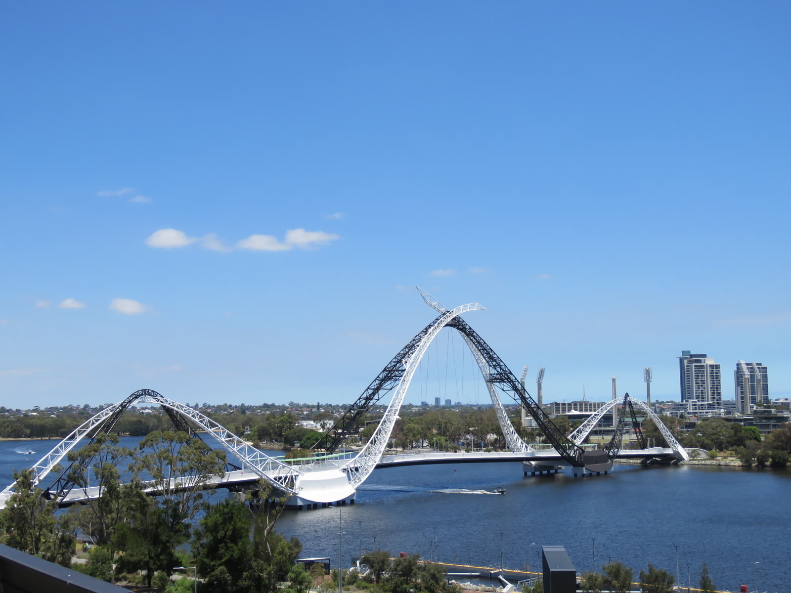
This is a one-anchor route. The anchor is the bridge, not because it is rare architecture in isolation, but because it makes several Perth habits visible at once: river walking, bike commuting, stadium movement, sunset watching, feature lighting, and the local tendency to use an impressive object casually. Tourism Western Australia describes Matagarup Bridge as a 370 m crossing over the Swan River linking Optus Stadium and the Burswood Peninsula to East Perth; Visit Perth adds the crucial operational detail that it is open all day, every day.[1][2]
The first local move is to approach from East Perth or Claisebrook rather than arriving straight at the stadium. If you begin at the Burswood side, the bridge can feel like an entrance ornament. If you begin on the city side, it behaves as infrastructure: you watch people peel off paths, cyclists adjust speed, runners hold their line, and stadium visitors become only one kind of user. A recent r/perth walking suggestion frames the longer version as a run or walk from Claisebrook Cove over Matagarup Bridge, around the stadium, and onward toward the Boorloo Bridge, with the full Swan River loop taking about two hours on foot.[7] For a visitor, shorten that idea. Do the bridge and immediate Burswood edge well instead of turning the day into a fitness errand.
The second move is timing. Go in daylight if you want clean orientation, or start about 45 minutes before sunset if the weather is calm and you can still see where bikes are moving. A local r/perth commenter recommended daylight for the bridge-and-river run but noted that finishing near sunset gives strong photo opportunities; another recent local thread says the bridge loop from Optus Stadium is pleasant on a calm evening.[6][7] That is the useful boundary. The route is not a night-only spectacle. It is a daylight crossing that becomes better if the evening light is kind.
The third move is to check the Optus Stadium calendar before treating the precinct as empty public space. The stadium lists major 2026 fixtures and events, and its own homepage emphasizes a year-round calendar for a 60,000-seat venue.[5] On event days, the bridge has a different job: moving crowds. That can be exciting if you want the civic surge, but it is the wrong version for this route. For the calmer street-microcosm read, choose a non-major-event day or arrive well outside gate-opening and post-event dispersal windows.
Once on the bridge, keep the etiquette simple. Stay to one side, do not stop in the moving lane, and take photos from the wider pauses rather than turning the arch into a blockage. This is the fourth move, and it matters because the crossing is shared by pedestrians and cyclists.[2] The fifth move is to look at the arches after you have looked at the river. Visit Perth explains the flowing forms as black and white swans or the Wagyl, a water-serpent important to local Noongar culture, while Tourism Western Australia frames the bridge as a symbol of connection.[1][2] Those readings land better if the bridge is not treated as a selfie frame first. Watch the actual connection: city bank to stadium bank, office pace to leisure pace, river to parkland.
The sixth move is to decide in advance whether you are walking the public bridge or buying the adventure version. The public crossing costs nothing and needs no booking. The commercial Zip+Climb version is a separate activity, with bridge-climb and zipline products, 314 steps, a 72 m SkyView platform, and a 400 m zipline listed by the operator.[9] Do not blur the two. If you want the climb, book it as the main event and accept the harness-and-time commitment. If you want the city read, keep your feet on the public deck and let the free crossing do the work.
On the Burswood side, resist the urge to sprint for the stadium facade. The seventh move is to turn around once before you leave the bridge landing. From that side, Perth's skyline is not a generic high-rise wall; it sits across the Swan River with the bridge ribs in the foreground and the stadium behind you. That is the route's small payoff. Local community notes keep returning to bridges, loops, and evening light rather than to a single "must-see" object, which is a clue about how Perth residents actually use this edge.[6][7]
The eighth move is to use the ferry only if it solves your return, not because every river route needs a boat. Visit Perth describes the Transperth ferry between Elizabeth Quay and Mends Street as an 8-10 minute crossing, typically every 15-30 minutes, with standard tickets and SmartRider accepted; the live Transperth ferry timetable is the source to check before relying on it.[3][4] That ferry is a good add-on if you are turning the walk into a broader river loop through South Perth. It is unnecessary if your attention is the Matagarup crossing itself. Do not overbuild the route.
There are three visitor traps. The first is arriving on a big stadium day by accident. The bridge may still be open, but the calm version disappears into managed crowd flow.[5] The better alternative is to check the event list first and pick a quiet evening. The second trap is crossing after dark without first seeing the geometry in daylight. Feature lighting is real, and Main Roads Western Australia maintains a lighting calendar for Perth landmarks, but the bridge is easier to understand when the river, bike paths, and stadium edge are still legible.[2][10] See it before you chase colors.
The third trap is turning the walk into a too-large loop because the map looks flat. Perth makes distance feel easy until wind, heat, or a late return changes the mood. A full Swan River loop can be around a two-hour walk in local community advice.[7] For this article's route, hold the core to 45-70 minutes: 10-15 minutes to approach and settle on the East Perth side, 10-15 minutes to cross slowly, 15-25 minutes to read the Burswood landing and stadium edge, and 10-15 minutes to return or redirect. If the weather is hot, cut the route before pride enters the plan.
Concrete go details: best window is a calm late afternoon, roughly 45 minutes before sunset, or a bright morning if you want cleaner path etiquette. Expected spend is 0 AUD for the public walk; add normal Transperth fare only if you extend the day with ferry or rail, and budget separately if you choose the paid climb or zipline.[3][4][9] Queue reality is none for the public bridge, but event-day pedestrian density can be the real queue. Navigation cue: aim for Matagarup Bridge from the East Perth/Claisebrook side, cross to the Optus Stadium edge, then decide whether to return the same way, keep walking around Stadium Park, or save the wider river loop for another day.[2][5][7]
The reason this small route works is that it refuses the usual Perth scale problem. You do not need to solve the whole city. Matagarup Bridge gives you a compact lesson in how Perth uses the Swan River: not only as scenery, not only as transport, not only as stadium access, but as a place where walking, cycling, events, light, and water share the same narrow line. Cross it slowly, keep out of the moving lane, and stop before the route becomes bigger than your attention.[1][2][6]
Sources
- Tourism Western Australia, "Matagarup Bridge" - official destination page on the 370 m Swan River crossing, East Perth to Burswood link, design symbolism, lighting, bridge climb, and zipline.
- Visit Perth, "Matagarup Bridge" - official city venue page listing the bridge's 370 m length, all-day opening, Burswood location, Noongar/Wagyl design context, nightly feature lighting, and public-access role.
- Visit Perth, "Boats and ferries" - official city page on the Transperth ferry between Elizabeth Quay and Mends Street Jetty, 8-10 minute crossing, 15-30 minute frequency, bike access, and ticketing.
- Transperth, "ferry Timetable" - live official ferry timetable page for checking current Elizabeth Quay and Mends Street ferry times before extending the walk.
- Optus Stadium, "What's On" homepage listings - official stadium event source for checking major 2026 fixtures and avoiding event-day crowd flow when planning a quiet bridge walk.
- Reddit / r/perth, "What to book in advance and must-see in Perth" - recent local/community thread recommending South Perth foreshore, the ferry, and the bridge loop from Optus Stadium on calm evenings.
- Reddit / r/perth, "American visiting for a few days, what do you recommend to check out?" - local/community thread discussing the Claisebrook Cove to Matagarup Bridge, stadium, Boorloo Bridge, and wider Swan River loop, including daylight and sunset timing advice.
- Wikimedia Commons, "File:Matagarup Bridge seen from Perth Stadium, December 2022 01.jpg" - real photograph by Calistemon used as the article image.
- Matagarup Zip+Climb, "Zip Climb Perth" - operator page for the paid bridge climb and zipline, including 314 steps, 72 m SkyView platform, 400 m zipline, and booking options.
- Main Roads Western Australia, "Matagarup Bridge" - official state page for bridge feature-lighting applications, lighting calendar, and event-use constraints around major stadium days.