New Orleans is easy to over-romanticize from a distance. People talk about the St. Charles streetcar as if the right move were simply to ride the whole line end to end and call that a day. The better local version is narrower. Pick one Uptown seam and let it stay small: board the St. Charles line around Jackson Avenue, ride outbound to Broadway, step off across from Audubon Park, and keep your attention on the live-oak median and the park loop instead of trying to "do" all of St. Charles at once.[1][4][5]
That tighter cut works because the avenue changes texture as you head upriver. New Orleans & Company describes St. Charles as tree-lined and mansion-heavy, with Tulane and Loyola sitting directly across from Audubon Park.[6] Local AskNOLA riders make the same point in plainer language: the houses start getting especially good between Napoleon Avenue and Audubon Park.[5] That is the stretch where the route stops feeling like transport nostalgia and starts behaving like a real neighborhood surface.
The transit mechanics are simple enough to keep the route light. NORTA's current streetcar schedule still prices a single ride at $1.25, includes a two-hour transfer, and keeps a 1-Day Jazzy Pass at $3.00.[1] On the current outbound tables, Jackson to Broadway is roughly an 18-minute ride on the evening pattern, which is just enough time for the canopy to settle in without turning the trip into a project.[1] Once you get off, Audubon Park itself stays open daily from 5 a.m. to 10 p.m., with a shaded 1.8-mile paved loop, water fountains, bathrooms, and exercise equipment.[3][8]
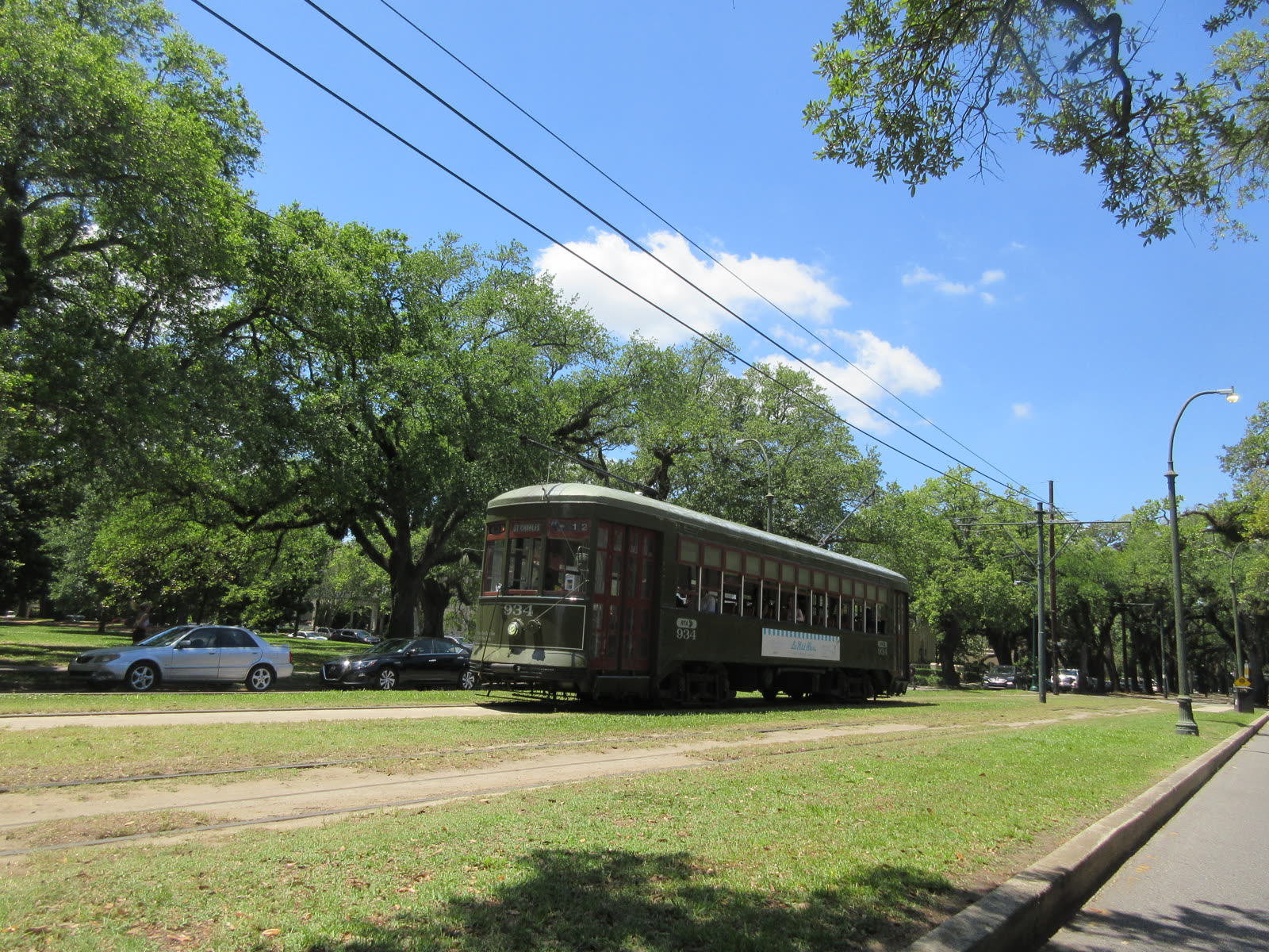
Image context: the cover uses a real documentary photograph of a St. Charles streetcar passing Audubon Park, because the whole argument depends on one exact relationship: green car, live oaks, and park edge in the same frame.[11]
Why this Uptown seam works better than the full-line fantasy
The full St. Charles line has charm, but charm is not the same thing as yield. If you try to "cover" the avenue, you spend too much of the outing watching transfers, stop spacing, and downtown logistics. If you enter around Jackson or Washington instead, the route gets straight to the useful part: older houses, thick shade, the neutral ground carrying the rails, and then the park waiting directly across from Broadway.[1][6][9]
That local phrase matters. AskNOLA runners still tell visitors to think in New Orleans directions first as upriver/downriver and riverside/lakeside, not as abstract compass bearings, because the city's long strips follow the river's logic more than the map's grid.[9] On this route, that means you are not just riding "west." You are sliding upriver into a slower Uptown register where the avenue, the universities, and the park all line up cleanly.
Audubon Park is the right second anchor because it does not ask you to invent an itinerary after you get off. The park's official page and the city's running guide agree on the basics: this is a public green space with ancient live oaks, a 1.8-mile loop, and enough shade that the place holds even in the bright part of the day.[3][8] The result is unusually forgiving by New Orleans standards. The streetcar gives you the arrival; the park gives you the dwell.
8 local moves that materially improve the route
First, cut into the line around Jackson or Washington instead of insisting on a ceremonial downtown start. The strongest section begins once the avenue has room to breathe.[1][5][6]
Second, ride outbound and ring for Broadway on purpose. AskNOLA locals still remind visitors that the car will not stop just because you look interested; you need to signal or have someone visibly waiting.[4]
Third, treat Broadway as the working dismount, not the absolute end of the line. Tulane, Loyola, and the park are already right there; staying aboard longer weakens the seam.[1][6]
Fourth, keep the streetcar ride short enough to stay atmospheric. Jackson to Broadway is about 18 minutes on the current outbound schedule, which is the sweet spot for this route.[1]
Fifth, use the park loop as your real pause. Audubon Park's paved 1.8-mile circuit has shade, bathrooms, water fountains, and exercise stations, so you do not need to improvise your landing once you get off.[3][8]
Sixth, work with the city's directional language. If someone tells you to head upriver toward Audubon or lakeside across the avenue, that is not local color; it is the practical navigation system people still use.[9]
Seventh, use NORTA BusTime before you walk to the stop. The Broadway stop page shows real-time predictions and stop text info, which is the cleanest way to keep the outing from turning into a stand-around.[2]
Eighth, save the return decision until after one park loop. With a $1.25 fare and a two-hour transfer window, you have enough flexibility to decide whether the ride back is worth it only after the park has landed.[1]
Non-local trapline: 4 common mistakes and the cleaner alternative
Mistake 1: trying to conquer the whole St. Charles line in one sitting
Better move: cut into the Uptown section and keep the route tight. The point is not total coverage; it is getting the best canopy-and-park seam.[5][6][9]
Mistake 2: staying on past Broadway because the end of the line sounds more complete
Better move: get off when Audubon Park becomes available. Broadway is where the streetcar and the park lock together.[1][3][6]
Mistake 3: forgetting that a request stop still needs a request
Better move: ring the bell before Broadway and watch your stop. Local riders still flag this because first-timers assume the car will stop automatically.[4]
Mistake 4: treating Audubon Park as zoo overflow instead of a real second room
Better move: walk at least one loop or one half-loop before deciding what comes next. The park is not filler; it is the reason this seam works.[3][8][10]
Concrete go details
- Best time window: late morning for cooler shade and easier pacing, or the 4-7 p.m. shoulder if you want the avenue to feel more social without turning the route into a night plan.[3][5]
- Expected spend: $1.25 for a single ride, $3.00 if you want the 1-Day Jazzy Pass safety net.[1]
- Queue and reservation reality: no reservations; the real variable is vehicle spacing, so check NORTA BusTime before you walk over.[2]
- Where to stand or sit: take a window on the park side if available, then do your real standing and slowing once you are inside Audubon's shaded loop.
- Navigation cue:
St. Charles around Jackson/Washington -> outbound car -> ring for Broadway -> cross into Audubon Park -> one 1.8-mile loop or a shorter shaded drift. - Numeric anchors worth keeping: $1.25, 2-hour transfer, $3.00, about 18 minutes from Jackson to Broadway, 1.8 miles, 5 a.m.-10 p.m..[1][3][8]
New Orleans has many routes that reward drift. This one rewards restraint. A short ride, one bell pull, one park loop, and a canopy of live oaks are enough to turn the city's most famous streetcar from symbol back into use.
Sources
- New Orleans RTA, "Streetcars" PDF (published 2026-04-03; current St. Charles schedule, Jackson/Broadway timing, $1.25 single ride, $3.00 day pass, and two-hour transfer rule).
- New Orleans RTA BusTime, "St Charles at Broadway - ETA" (real-time prediction page for stop 3602 on route 12).
- Audubon Nature Institute, "Audubon Park" (official park page; daily 5 a.m.-10 p.m. hours, historic Uptown setting, live oaks, and public amenities).
- r/AskNOLA, "St Charles Streetcar" (published 2026-01-01; local rider notes on using the Canal/Carondelet start, ringing the bell, and getting off at Audubon Park).
- r/AskNOLA, "St. Charles streetcar still partially closed?" (published 2025-05-06; local note that the ride is most atmospheric between Napoleon and Audubon Park, with a useful 4-7 p.m. social window).
- New Orleans & Company, "St. Charles Avenue" (official local guide; tree-lined avenue, mansion fabric, and Tulane/Loyola opposite Audubon Park).
- New Orleans & Company, "Oak Trees in New Orleans" (official local guide recommending the streetcar for the full live-oak stretch).
- New Orleans & Company, "Jogging & Running" (official local guide; Audubon Park's 1.8-mile paved path, bathrooms, water fountains, and near-full shade).
- r/AskNOLA, "Running recommendations" (published 2026-03-26; recent local note on upriver/downriver navigation, the neutral ground, and combining the St. Charles tracks with the Audubon loop).
- Google Maps community listing, "Audubon Park, New Orleans."
- Wikimedia Commons, "File: Streetcar on St Charles Avenue New Orleans 1 May 2024 - Car 934 passing Audubon Park.jpg" (documentary cover photograph source).