Mexico City has grander cultural pairings than this one, but few are more useful on an ordinary afternoon. Biblioteca Vasconcelos and the Kiosco Morisco sit close enough to be treated as one seam, yet they solve different urban needs. The library gives you scale, suspension, and a civic interior that is still genuinely public. Santa María la Ribera gives you neighborhood tempo: benches, corridor movement, local families, older couples, teenagers drifting through the alameda, and a pavilion that works less like a monument than like a neighborhood hinge.[1][4][5]
The route only works if you keep it narrow. This is not "do Buenavista and then maybe Santa María." It is one late-day microcosm built on two anchors:
- Biblioteca Vasconcelos for the public interior, the reading-floor atmosphere, and the Buenavista arrival logic.
- Kiosco Morisco for the short release into neighborhood air once the library's vertical coolness has done its work.
The local texture is what makes this pairing worth publishing. The official city guide describes the Kiosco Morisco as the key piece of Santa María la Ribera, tracing it from the 1884-1885 New Orleans exposition to Alameda Central and finally to the neighborhood in 1910.[4] Local press still describes Santa María as the city's first modern-style subdivision and explicitly advises visitors to forget the car for a while and read the area on foot.[5] Put together, those facts tell you what this route really is: a short walk from one civic machine to one neighborhood emblem, with almost no dead space in between.
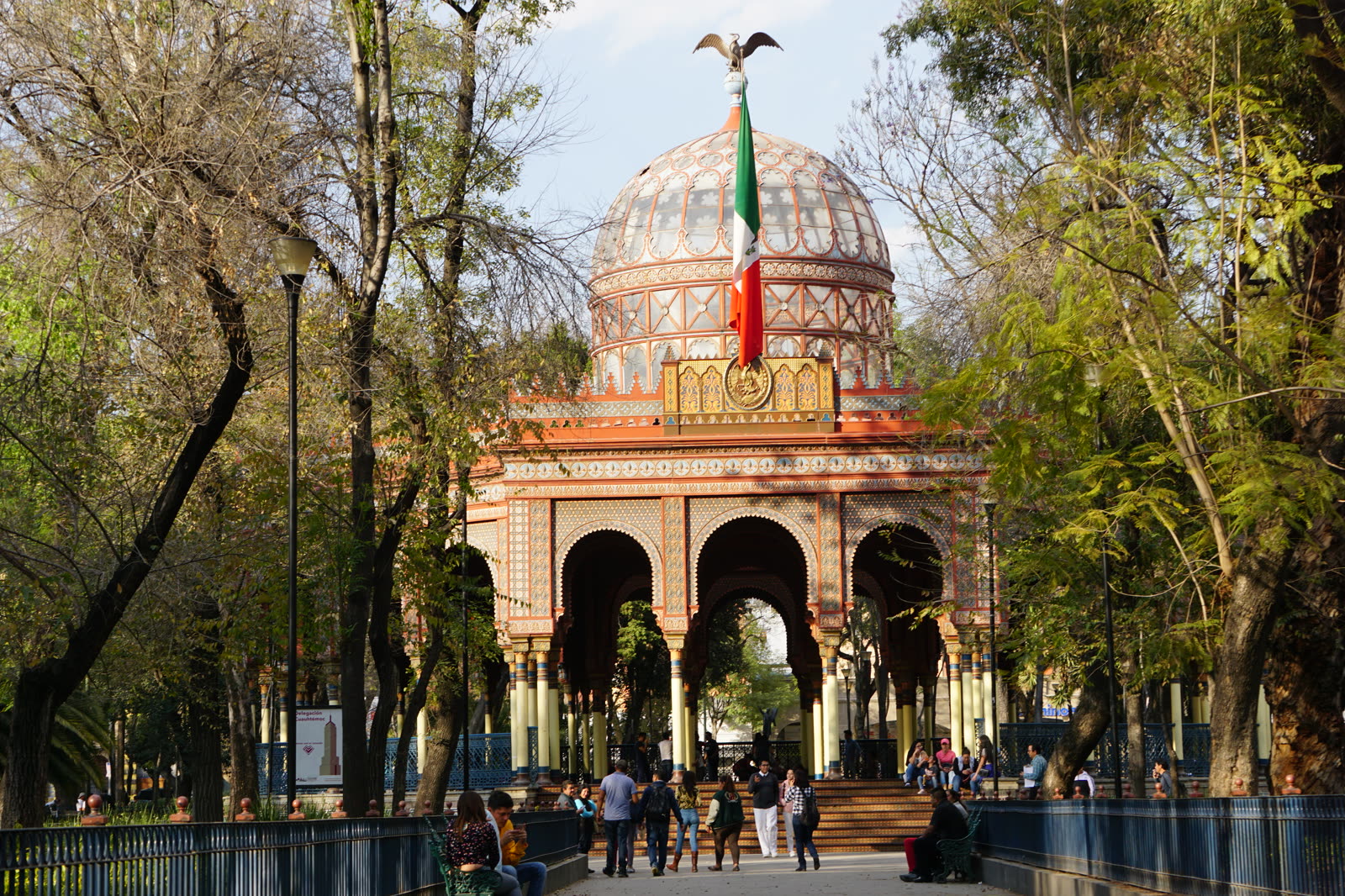
Image context: the cover uses a real documentary photograph of the Kiosco Morisco in the alameda. That is the correct visual cue for this article because the route is not about generic "pretty architecture." It is about arriving at one recognizable neighborhood landmark after leaving one of the city's most unusual public interiors.[4][12]
Anchor 1: Biblioteca Vasconcelos works best as a timed public room, not as a quick photo errand
The official library site is unusually clear about the baseline: services and activities are free, the library sits on Eje 1 Norte Mosqueta in Buenavista, and its orientation modules operate Monday to Sunday from 8:30 to 19:30.[1][2][3] Those numbers matter because they tell you the building is not merely a symbolic cultural stop. It is run as a daily-use institution.
That everyday-use character shows up in local and community signals too. A recent Chilango event listing still frames the library as a live venue, not a frozen architectural sight, noting a 498-seat auditorium program and pointing visitors toward Metro Line B and Metrobús Line 1 at Buenavista.[7] In a March 2026 Reddit thread, one recent visitor answered the most practical question in the simplest possible way: the library is "super close" to Buenavista station and easy to reach.[9] That is exactly the route logic you want. The arrival should feel almost too easy, because the work is not in getting there. The work is in timing it so the building is still alive as a public room when you enter.
My inference from the official 19:30 closing rhythm plus the neighborhood second act is that the cleanest arrival sits around 16:45 to 17:15.[2][4][5] Earlier than that, the route loses some of its evening handoff. Later than about 18:15, you start compressing the second anchor too hard and risk turning the walk into a sprint rather than a shift in atmosphere.
One more local lesson matters here: verify same-day notices before you leave. The official site regularly publishes special-hour and closure notices, and the September 12, 2025 reopening covered by Chilango is a reminder that access conditions can change abruptly around labor or calendar issues.[2][6] That does not make the library unreliable. It means you should treat it like a living institution rather than a postcard.
Anchor 2: the Kiosco Morisco is where the route turns from civic scale into neighborhood cadence
The Kiosco Morisco is one of those places that gets flattened by overfamiliarity. Everyone knows the dome. Fewer people use it at the right speed. The city guide's history is already enough to sharpen your reading: the pavilion was built for an exposition, moved, reassembled, used again, and finally settled into Santa María as the neighborhood's visual center.[4] Local coverage adds the piece visitors actually need. Santa María remains a barrio with strong self-recognition, and the alameda is still the obvious social core.[5]
That is why this second anchor should come after the library, not before it. Biblioteca Vasconcelos heightens your eye for structure and distance. The Kiosco then gives you iron filigree, trees, dogs, corridor circulation, and the softer human noise of a neighborhood park. Chilango's neighborhood piece is especially useful here because it notes the local Sunday dance habit in the park corridors and frames the area as somewhere to discover by walking rather than by hopping between isolated attractions.[5] Even when there is no Sunday dance, that is the right reading: this is a room the neighborhood keeps using.
Apple Maps currently treats the Kiosco as a place that is effectively open 24 hours, which is useful not because you should camp there all night, but because it confirms the second anchor is public-space time, not ticket time.[11] The core route therefore stays cheap and flexible: library at MXN 0, alameda at MXN 0, with your only real cost being transit if you are not already in the area.[1][4][10][11]
8 local moves that materially improve the route
- Use Buenavista as the entry logic, not as a place to linger. Chilango's local directions and recent community comments both point you straight to the library from the transit node.[7][9]
- Arrive at the library around 16:45-17:15 so you still get live reading-room energy without sacrificing the evening turn in Santa María.[2][4][5]
- Check the library's same-day notices before leaving your hotel or apartment. The routine schedule is broad, but exceptions are real.[2][6]
- Treat the library as a public-use room first and a photo stop second. The building reads better when you let people studying, reading, and circulating stay part of the atmosphere.[1][7][9]
- Keep the inter-anchor walk on foot. Local coverage explicitly says to forget the car for a while in Santa María, and this route loses meaning if you insert a ride between the two anchors.[5]
- Hold the library for about 45-75 minutes, then let the Kiosco take the longer pause. The first room is vertical and interior; the second should be slower and outward-facing.[2][4][10][11]
- At the Kiosco, do not stay pinned directly under the dome. Walk the alameda edge, then choose a bench or standing point that lets you read both the pavilion and the neighborhood traffic around it.[4][5]
- Keep the core budget at MXN 0-20 unless you deliberately add coffee or food. The route is built around public infrastructure and public space, not transactions.[1][4][10][11]
Non-local trapline: 4 mistakes that flatten the experience
Mistake 1: treating Biblioteca Vasconcelos as an architecture-only photo errand
Better move: enter while the reading floors are still active and let the building function as a real public room before you start thinking about your next stop.[1][2][7][9]
Mistake 2: assuming the posted routine means the library can never shift hours
Better move: use the official schedule, then check for day-of notices or special announcements before setting out.[2][6]
Mistake 3: using a car or ride-hail between Buenavista and Santa María
Better move: keep the seam intact on foot. The whole point is to feel one district-scale transition rather than two disconnected attractions.[5][8]
Mistake 4: reaching the Kiosco, taking one centered photo, and leaving immediately
Better move: let the alameda work on you for a while. The pavilion matters most as the center of neighborhood circulation, not as a single-frame object.[4][5][11]
Concrete go details
- Best time window: enter Biblioteca Vasconcelos around 16:45-17:15, leave roughly 60 minutes later, and let the Kiosco side take over from about 18:00 onward.[2][4][5][10][11]
- Expected spend: MXN 0-20 for the core route, depending on whether you are already arriving on a prepaid transit card or need one ride into Buenavista.[1][4][10][11]
- Queue and reservation reality: no ticketing pressure for either anchor, but the library can post special-hour notices and the Kiosco gets denser on local-event or Sunday-neighborhood cycles.[2][5][6][11]
- Where to stand or sit: stand briefly inside the library's main volume to register the suspended stacks, then take your longer sit on the alameda edge where the Kiosco and pedestrian flow stay in the same frame.[4][5]
- Navigation cue:
Buenavista -> Biblioteca Vasconcelos -> walk into Santa María la Ribera -> Alameda -> Kiosco Morisco.[3][4][7][8][9] - Numeric anchors worth keeping in your head: 8:30, 19:30, 16:45-17:15, 45-75 minutes, 18:00, 1884-1885, 1910, 498 seats, Metro Line B, Metrobús Line 1.[2][4][7]
Mexico City gets too schematic when you only chase major center-city monuments. This short Buenavista-to-Santa-María seam is better because it stays close to the ground. One anchor suspends you inside a civic machine. The other returns you to a neighborhood park where the city loosens again.
Sources
- Biblioteca Vasconcelos, official homepage - free services and general institutional overview.
- Biblioteca Vasconcelos, "Módulos de orientación" - official orientation-module hours, Monday to Sunday from 8:30 to 19:30.
- Biblioteca Vasconcelos, official directory - Buenavista address and contact details.
- Mexico City official city guide, "El Quiosco Morisco y la Alameda de Santa María" - pavilion history, address, and neighborhood role.
- Chilango, "Santa María la Ribera, el lugar que lo inició todo" (June 4, 2024) - local neighborhood reading, on-foot advice, and the alameda's social life.
- Chilango, "Reapertura de la Biblioteca Vasconcelos: ¿a partir de cuándo?" (September 12, 2025) - recent local confirmation that access conditions and reopening notices can change.
- Chilango, "Concierto música clásica GRATIS en Biblioteca Vasconcelos: fecha" (May 2025) - recent local listing with Buenavista transit access and auditorium capacity.
- Reddit / r/MexicoCity, "Walking route through colonias San Rafael and Santa Maria la Ribera" - recent community route signal connecting Santa María's core stops on foot.
- Reddit / r/MexicoCity, "First visit to Mexico City - Photos of Biblioteca Vasconcelos" - recent community note that the library is very close to Buenavista station.
- Apple Maps, "Biblioteca Vasconcelos" - current place page with public-library hours and location details.
- Apple Maps, "Kiosco Morisco" - current place page showing the landmark and all-day public access surface.
- Wikimedia Commons, "File:El Kiosko Morisco, Santa Maria La Ribera.jpg" - documentary image source used for the cover photo.