Do not ride Mexico City's Cablebus Line 2 because it looks cinematic from Instagram. Ride it because it changes the shape of the city. The move is simple: take Metro Line 8 to Constitucion de 1917, tap into the Cablebus, ride east over Iztapalapa, pay attention at Xalpa, and decide whether you want the full run to Santa Marta or a shorter out-and-back that still teaches you something.
This is a ritual lens, not a transport completist's checklist. Line 2 is a roughly 10.6-kilometer public cable-car route with 7 stations between Constitucion de 1917 and Santa Marta; system guides put the end-to-end ride in the 36-to-40-minute range, compared with more than an hour by older ground routes [1][3]. That number matters, but the stronger travel lesson is spatial. From above, Iztapalapa stops being "far out east" and becomes a dense, specific city inside the city: hills, painted roofs, schools, markets, apartment blocks, volcano-line horizon, and the daily logic of people moving toward work, school, Metro Line 8, and Metro Line A.
The best first-timer window is a weekday after the morning push: aim for 10:00 to 12:00, or use 14:00 to 16:00 if the weather is clear and you want softer light. Avoid making your first ride a commuter-peak experiment unless you already use Mexico City transit comfortably. There is no reservation reality here; this is turn-up-and-ride public transport. The expected spend is modest: local system guides list access at 7 pesos, paid through the city's integrated mobility card, while the Mexico City tourism guide reminds visitors that the card is needed for Cablebus as well as the Metro [1][2][3]. Carry the card before you arrive at the gate. Do not treat the terminal as the place to solve your whole transit life.
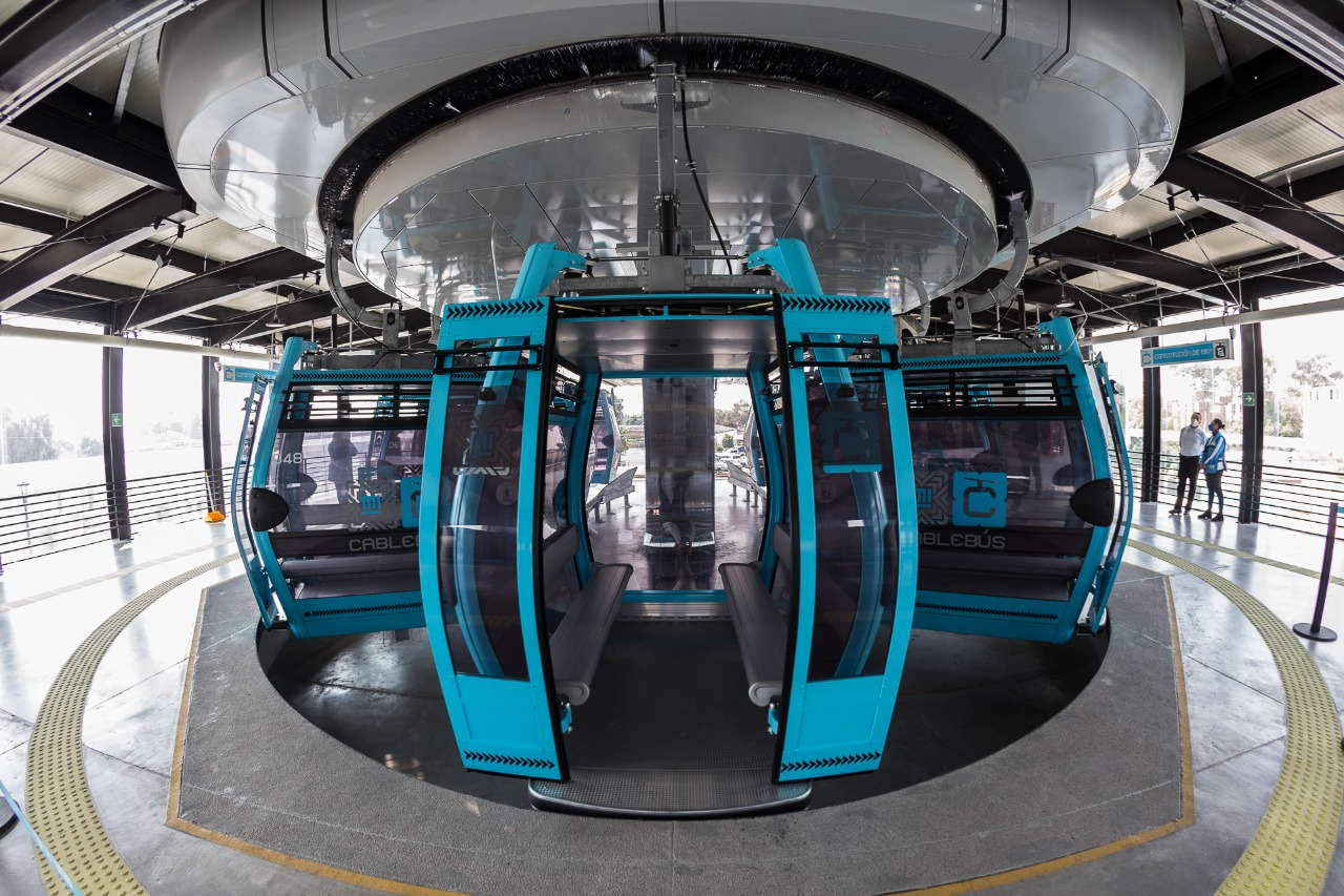
Local move one: start underground and climb deliberately. Line 8 delivers you to Constitucion de 1917; from there, follow the Cablebus signs rather than exiting into the bus-terminal churn too early. The navigation cue is the simplest possible one: if the line starts to feel like a CETRAM maze, keep looking for the Cablebus icon and the elevated station structure, not for a street landmark. Mexico City's official visitor page frames the station as a clean entry into Iztapalapa because it sits at the Metro connection and opens the borough from above [2].
Local move two: decide your endpoint before tapping in. A full ride to Santa Marta is the clearest version if you have 70 to 90 minutes including Metro transfer, station time, and a margin for confusion. A shorter ride to Xalpa and back is enough if you only want the spatial lesson and do not want to manage an east-end onward plan. The non-local mistake is assuming this is one smooth tourist loop. A recent r/MexicoCity thread from late May 2026 is useful precisely because a rider thought they had done the whole route, then learned from locals that Line 2 is divided and that Xalpa is the transfer point [4]. Watch the station names. If everyone exits at Xalpa, that is information, not a malfunction.
Local move three: sit facing the city, not only the skyline. The distant towers to the northwest are easy; the better reading is below the cabin. The UITP case sheet describes Line 2 as a social mobility project through high-density areas, with more than 300 ten-passenger cabins, 78,000 daily trips, 7 recovered public spaces, 2,648 LED luminaires, and 7,400 painted houses along the corridor [3]. That is the texture to look for. The roof color is not decorative filler. It is part of an urban-recovery effort that makes the route visible from the air and from the street.
Local move four: keep your group small. Four people can move through the station without clogging the cabin rhythm; ten people become a logistics problem. The cabins themselves seat 10, but that does not mean your group should turn the ride into a private compartment [3]. Let commuters enter first when the flow is heavy. If you are taking photos, keep the phone inside the cabin and skip flash against the glass. The view is good enough without performing the ride.
Local move five: treat Xalpa as the hinge. If you continue east, be ready to get out and reboard on the second section. If you turn back, do it cleanly and do not drift into the wrong direction because the map looked like one line on your phone. This is where visitor confusion clusters, and it is also where the route's engineering becomes legible: one public line, two operating sections, one shared travel story [4].
Local move six: if you go all the way to Santa Marta, know your exit before you arrive. Santa Marta is useful because it connects to Metro Line A and the eastern edge of the network, not because it is a soft landing for aimless wandering. If you want the cleanest first pass, ride to Santa Marta, transfer to Line A only if you already know your next stop, or reverse back through the Cablebus system. If you are tired, hungry, or losing attention, turn back at Xalpa instead of improvising at the far end.
Local move seven: use mapping apps as confirmation, not command. Google Maps listings and local review surfaces are handy for checking station names, entrances, recent crowd comments, and nearby orientation, but the station signs and staff matter more once you are in the system [6]. This is especially true at Constitucion de 1917, where Metro, bus, and Cablebus flows overlap.
The trapline is short. Trap one: riding only for the skyline. Better alternative: make the roofscape, public-space interventions, and hill geography the subject. Trap two: showing up with luggage. Better alternative: do the ride light, with one hand free and no suitcase to drag through station changes. Trap three: assuming Iztapalapa is a danger anecdote rather than a borough. Better alternative: read it as working urban fabric and keep your behavior ordinary: no gawking into homes, no lens pressed into other people's commute. Trap four: overplanning a food or bar stop around the ride. Better alternative: let this be a transport-and-place ritual, then eat back in a neighborhood where you already know your route home.
There is a current-city reason to do this now. On Line 2's fourth anniversary in August 2025, Excelsior reported that the Iztapalapa route still stood as the system's longest urban cable-car line, that Cablebus had three lines in operation, and that the city was preparing several more [5]. That matters for visitors because Line 2 is not the new novelty line. It is the mature proof of concept: a working eastern route whose value is less about spectacle than about time, access, and the politics of making a huge borough feel connected.
Plan the whole move as a 2-hour block from a central-neighborhood start, or 90 minutes if you are already near Line 8. Best case: 30 to 40 minutes from central Metro territory to Constitucion de 1917, 36 minutes for the official end-to-end Cablebus ride, plus 10 to 20 minutes of station and transfer friction [1]. Build slack. Mexico City rewards slack more than cleverness.
The image to keep in your head is not a cabin floating above the city. It is the moment after the doors close at Constitucion de 1917, when the ground drops slightly, the Metro system falls behind, and Iztapalapa stops being an abstraction on the eastern edge of a visitor map. For the price of a short transit ride, Line 2 lets you see the city as residents often experience it: not as a set of attractions, but as a chain of links that either respect time or steal it.
Sources
- Diario CDMX, "Cablebus CDMX: cuales son las lineas, estaciones y costo" - local guide with fare, hours, card note, Line 2 stations, length, connections, and travel-time summary.
- MexicoCity.cdmx.gob.mx, "Constitucion de 1917, Cablebus Line 2" - official visitor-facing station guide with Metro connection, Iztapalapa context, and integrated mobility card note.
- UITP, "Cablebus L2" - recent system case sheet covering fare, cabins, daily trips, public-space recovery, lighting, and painted-house figures.
- Reddit r/MexicoCity, "Confused about Cablebus line 2" - recent local/community thread clarifying the Xalpa transfer behavior and visitor confusion.
- Excelsior, "Clara Brugada celebra 4 anos de operacion de Linea 2 del Cablebus" - August 8, 2025 report on Line 2's fourth anniversary, current ridership context, system scale, and expansion plans.
- Google Maps, "Cablebus Constitucion de 1917" - local listing and review surface useful for entrance, station, and crowd-orientation checks.
- Wikimedia Commons, "Cablebus Constitucion de 1917.jpg" - photographic source for the article image, credited to Sistema de Transportes Electricos / Cablebus / Gobierno de la Ciudad de Mexico.