La Paz becomes more readable when you stop trying to cover it from street level first. The first move should be vertical and public: enter Mi Teleferico at Estacion Central, ride the Red Line through Cementerio, and get off at 16 de Julio in El Alto before deciding whether to transfer onward or come back down. Treat the cabin as a moving map, not as a novelty ride.[1][3]
The Red Line is small enough to use correctly. Bolivia's public works ministry lists it as Estacion Central -> Estacion Cementerio -> Estacion 16 de Julio, with an 11-minute end-to-end run; the same recent official notice gives the network's normal service window as 06:30 to 22:30 Monday-Saturday and 07:00 to 21:00 on Sundays and holidays.[1] That is the right scale for a first pass. You are not solving the whole system. You are learning the city's main trick: La Paz and El Alto are one urban organism split by altitude, traffic, markets, ravines, and the daily need to move between them.
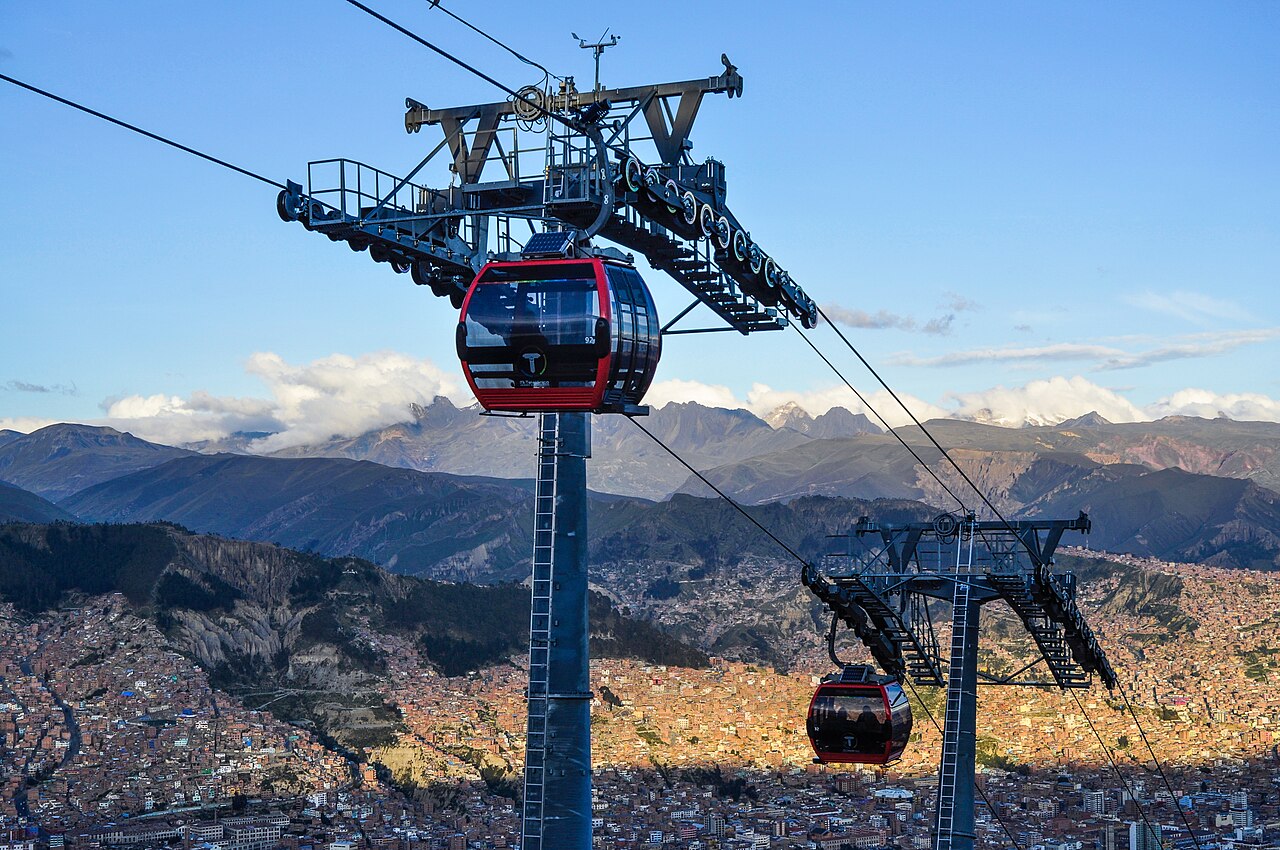
The cover image uses a 2016 Wikimedia Commons photograph by EEJCC because it shows the actual subject: a Red Line cabin above dense hillside city fabric, with the mountain backdrop visible but not allowed to become the whole story.[6]
Ride It As Transport First
The most common visitor mistake is to make Mi Teleferico into a sightseeing loop before understanding why locals value it. The fare structure keeps the system in daily-life territory: the current official notice lists the family fare at Bs 3 for the first line and Bs 2 for a transfer, with lower student and preferred fares.[1] A local Bolivia tourism guide describes the same basic logic and adds one useful mechanical detail: bicycles can be carried, but at double fare.[2] The point is not that a visitor must bring a bike. The point is that the system behaves like transport with rules, not like an observation wheel.
Start at Estacion Central because the name is literal and historical enough to orient you. La Paz Life notes that Red Line stations carry Spanish and Aymara names and gives the central-to-16-de-Julio segment as 2.4 km, three stations, and roughly 10 minutes in older route data.[3] Even if you ignore every other number, keep the station sequence in your head. Central is the low-city hinge. Cementerio is the reminder that this line is not a tourist corridor detached from ordinary neighborhoods. 16 de Julio is the threshold into El Alto, where the ride stops being about a view and starts being about how much city exists above the city.
The local move is to board without blocking the cabin door, sit if a seat is open, and face diagonally rather than gluing yourself to the window. The diagonal view lets you see both the next tower and the street grid below. If commuters are moving quickly, let them. If the cabin fills, keep bags on your lap or at your feet. A review summary pulling from Google reviews praises the system as clean, useful, calm, and panoramic, but also includes a recent complaint about long Red Line queues on Thursdays and Sundays.[4] That is not a reason to skip it. It is a reason to avoid treating 16 de Julio market time as a frictionless postcard.
What The Cabin Teaches
La Paz is famous for altitude, but the cabin makes altitude social rather than abstract. La Paz Life frames the cable car as operating around 4,000 meters above sea level and says the system changed trips between La Paz and El Alto that could take about an hour by road into something closer to a 10-minute crossing on the original line.[3] The number is useful because it gives you permission to move slowly after arrival. At 16 de Julio, do not sprint off into the market just because the ride was easy. Step out, breathe, orient, and watch where the confident local flow goes before following.
This is where the Red Line beats a taxi for a first morning. A taxi hides the slope inside switchbacks and traffic. The teleferico exposes it: roofs, courts, retaining walls, market roofs, cemetery edges, and the bowl of the city all pass under you in one continuous argument. That is the non-tactical detail that makes this route La Paz rather than a generic cable car city. The cabin turns topography into public habit.
Local community advice backs the route shape. In a recent r/BOLIVIA travel thread, a commenter recommends the telefericos as a must-do, notes the Bs 3 first segment and Bs 2 contiguous transfer pattern, and suggests starting on the Red Line at Estacion Central before continuing through connected color lines if you want a longer cross-city route.[5] For a first visit, keep that longer route as an option, not a duty. Red to 16 de Julio and back is enough if the altitude, crowd, or weather tells you to stop.
8 Local Moves That Make It Work
- Go after the commuter crush, not at the exact morning rush. The operating day is long enough that you can aim for a mid-morning or late-afternoon ride while still staying inside official hours.[1]
- Use Estacion Central as the clean start. It gives you a simple entry point and the clearest low-to-high sequence: Central, Cementerio, 16 de Julio.[1][3]
- Carry small bolivianos even if you plan to use a card. The base mental model is still Bs 3 first line, Bs 2 transfer; having cash keeps a small ride from becoming a payment problem.[1][5]
- Tell station staff if you are confused during a transfer. Review-derived advice specifically warns that transfer handling can affect charges, so ask before tapping through uncertain gates.[4]
- At 16 de Julio, pause before committing to the market. The altitude and crowd pattern deserve a two-minute reset, especially for first-day arrivals.[4]
- Avoid Thursday and Sunday if you dislike queues. Community review data flags Red Line pressure on those days; choose a calmer window when the ride itself is the goal.[4]
- Do one transfer only if the first ride feels easy. The r/BOLIVIA route suggestion continues through Red, Silver, Yellow, and Green toward Irpavi, but that is a second layer, not the minimum viable La Paz lesson.[5]
- Keep the camera secondary until the cabin clears. The best recognition cue is not one perfect shot; it is noticing how the city changes between each tower and station.[3][6]
Non-Local Trapline
Mistake 1: riding the whole network on day one because the colors look simple. The better move is to make the Red Line your first object. Three stations and around 11 minutes are enough to understand the height relationship without turning the day into transit tourism.[1]
Mistake 2: treating 16 de Julio as merely a viewpoint. The better move is to read it as a working transfer and market zone. Get out, clear the exit, decide calmly, and do not let the view make you sloppy with bags or direction.[4][5]
Mistake 3: assuming the cable car replaces local judgment. The system is orderly, but weather, queues, altitude, and market days still matter. If the line is pressured, the smart move is timing, not impatience.[1][4]
Mistake 4: skipping the cabin because taxis feel easier. The taxi may be easier for luggage. It is worse for understanding the city. The Red Line shows you, in one public ride, why a steep metropolitan region built a sky-level everyday transport system.[2][3]
Concrete Go Details
- Best time window: mid-morning or late afternoon on a clear weekday, staying well inside the 06:30-22:30 Monday-Saturday and 07:00-21:00 Sunday/holiday windows.[1]
- Expected spend: Bs 3 for the first line and Bs 2 for a transfer under the current official fare notice; budget more only if you deliberately continue across several colors.[1][5]
- Queue reality: no reservation; expect possible pressure around Thursday and Sunday patterns reported in local review data, especially near 16 de Julio.[4]
- Navigation cue:
Estacion Central -> Linea Roja -> Cementerio -> 16 de Julio; transfer onward only after you have oriented at the platform level.[1] - Where to stand or sit: clear the cabin door first, sit if available, and favor a diagonal view that catches both the next tower and the slope below.
- Numeric anchors worth keeping: 3 stations, 11 minutes, 2.4 km, Bs 3, Bs 2, 06:30, 22:30, 07:00, 21:00, and roughly 4,000 meters of high-city context.[1][3]
The Red Line works because it is both ordinary and astonishing. It costs like public transport, runs on a daily schedule, carries commuters and visitors in the same cabins, and turns La Paz's hardest fact into something visible: the city is vertical, and local life has learned to move through that verticality without pretending it is easy.
Sources
- Ministerio de Obras Publicas, Servicios y Vivienda de Bolivia, "Mi Teleferico opera con normalidad en sus 10 lineas de la red metropolitana" (recent official notice used for operating hours, fare structure, Red Line stations, and 11-minute travel time).
- iBolivia, "Teleferico de La Paz" (Bolivian tourism guide used for local route framing, fare-transfer logic, bicycle note, and network orientation).
- La Paz Life, "Mi Teleferico: La Paz's Cable Car System" (local travel guide used for route length, station names, altitude context, capacity context, and the La Paz-El Alto commute framing).
- Wanderlog, "Linea Plateada Linea Roja y Linea Azul Mi teleferico, La Paz, Bolivia" (Google-review-backed community page used for recent visitor notes on cards, acclimatization, views, and Red Line queue pressure).
- Reddit / r/BOLIVIA, "Quiero viajar a bolivia denme tips porfi" (recent local/community thread used for practical transfer fares and the Central-to-Red-Line route suggestion).
- Wikimedia Commons, "File:Linea Roja de Mi Teleferico en La Paz, Bolivia.jpg" (documentary photographic source page for the lead image by EEJCC, photographed January 15, 2016).