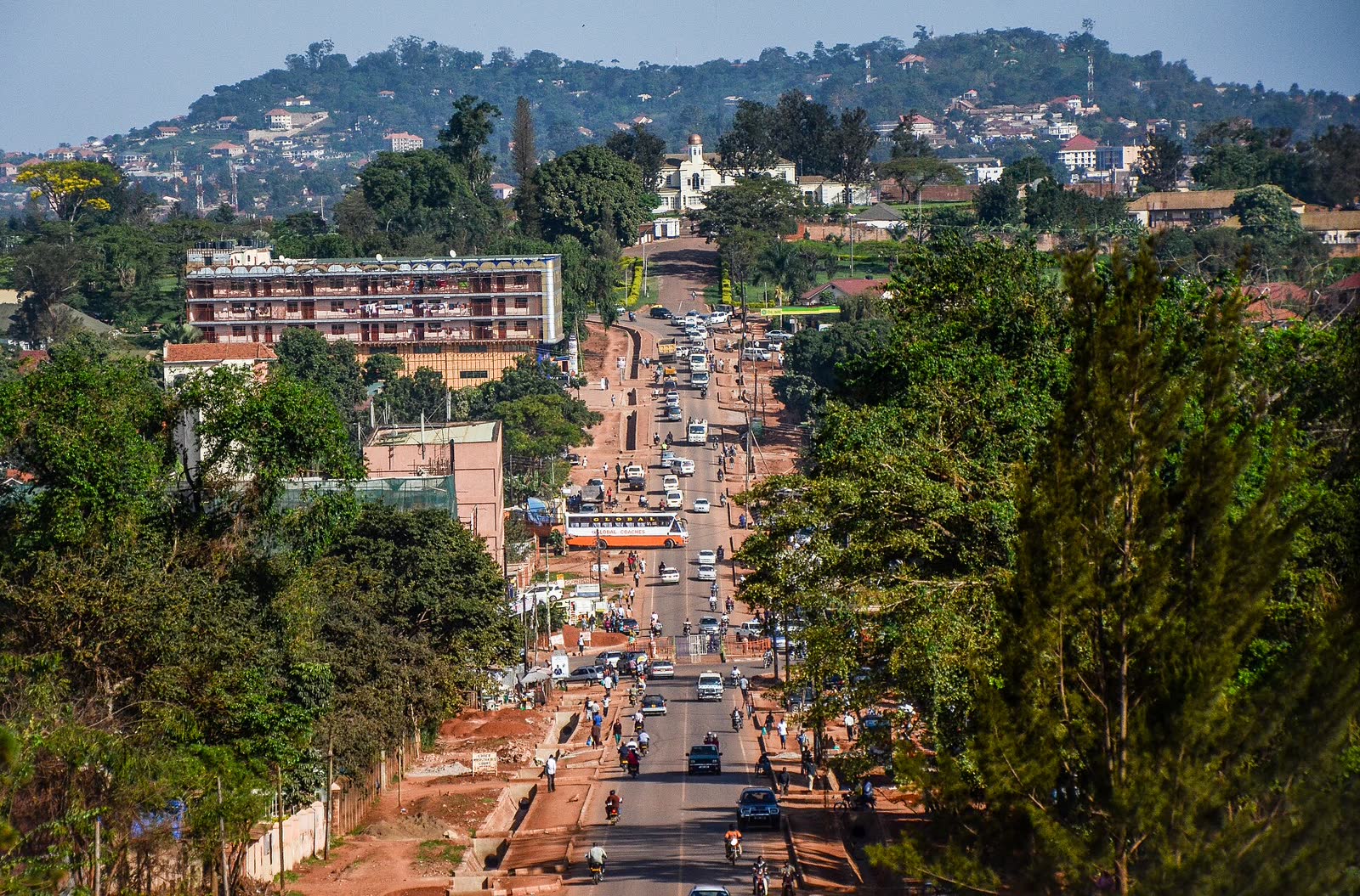
The rule appears in the road before anyone explains the history. Halfway along a remarkably straight Kampala avenue, every taxi, boda and private car bends around a roundabout. Through its center runs a narrow, gated line. That line is reserved for the Kabaka, the king of Buganda. Everyone else goes around.[3][4]
This small piece of traffic geometry is the reason to walk Kabaka Anjagala Road rather than merely drive past the two famous compounds at its ends. In about one mile (1.6 kilometers), the road links Bulange, seat of the Lukiiko or Buganda parliament, with Lubiri, the royal palace grounds.[3][6] The middle does not dilute those institutions. It shows how they inhabit the same city as school traffic, office errands, motorcycles, worshippers and people walking home. A January 2026 local account calls the mile a living spine used daily by civil servants, students, traders and worshippers; that is the right frame.[2]
Set aside 80 minutes, ideally within 09:00–10:30 on a normal weekday. A Uganda-based operator recommends weekday mornings from 09:00 to 11:00 for the palace; placing this street walk inside that locally recommended period leaves the compound as a separate decision.[9] The public-road walk itself costs UGX 0, needs no reservation and has no queue. Palace or parliament interiors are separate visits, with access controlled at their gates; the official city page describes guided interpretation at Lubiri but does not publish a current tariff or timetable, so do not build this walk around an unverified tour promise.[1] This is one non-food anchor, one direction, and one very particular rule about who may travel straight.
One mile, two kinds of authority
Begin at Bulange Mengo. Use that full name with a driver or in a map search; “parliament” can mean Uganda's national legislature elsewhere in central Kampala, and “palace” is a poor starting coordinate. A current walking route between Bulange Mengo and Kabaka's Palace gives you the paired endpoints, but the road itself supplies the navigation: keep the pale, symmetrical Bulange facade behind you and the Lubiri gate ahead.[5]
Bulange was completed in 1958 and remains the administrative seat of the Buganda Kingdom. Across the mile, the Lubiri represents the Kabaka's authority. Their alignment is the argument: legislature and monarch face one another rather than appearing as unrelated sights on a city circuit.[2][3] The road passes through Mengo, the kibuga, or city, of Buganda. Kampala did not simply grow around a dead royal relic; ordinary urban movement still crosses a functioning political landscape.
That is why the first local move is to remain outside for a while. Look at Bulange from the public approach, then start walking instead of immediately seeking an interior tour. The second is to choose one pavement and stay with it. Kabaka Anjagala is broad enough to tempt repeated crossings for photographs, but its beauty is linear. As a conservative road-safety rule, let motorcycles and cars keep their working rhythm; use a marked or obvious crossing when you need one, not every time a totem appears on the opposite side.
The clan figures along the route are not a sculpture checklist. The road-improvement account records 52 totems, while the local heritage map connects them to an older 52-tree clan scheme.[3][4] Those figures describe the historical planting and the installed sculptures, not a claim about the kingdom's current clan count. The map gives the name a social history as well as a translation: Kabaka anjagala—the king loves or needs me—was a phrase a subject might use after visiting the palace or receiving a candlenut seedling. The avenue's greenery was therefore once proof of relationship, not generic beautification.[3]
Choose two or three figures to examine rather than zigzagging to collect all 52. That is the third local move, and it preserves the road's scale. A Kampala-based walking reflection praises the rebuilt sidewalks, replanted trees and clan monuments precisely because they turn an important route into a place that can be read on foot.[6] The street works when the whole line stays visible.
At Nantawetwa, go around
Roughly 800 meters into the walk, the avenue's principle becomes physical. The midpoint monument is generally called Nantawetwa; the Cross-Cultural Foundation of Uganda's map prints the name as Entawetwa. Its center passage has a lockable gate, and the Kabaka alone may proceed through it. Other road users circulate around the sides.[3][4]
Do the same on foot. Do not step into the central channel for a symmetrical photograph, lean on its gate or treat the opening as a shortcut. Move around the monument with the traffic rule, pause from the pedestrian edge, and notice what the detour does: for a few seconds, every ordinary journey acknowledges a royal exception. This is the fourth local move and the mile's clearest piece of etiquette.
It is also a useful correction to the phrase “Royal Mile.” In another city, that label might promise souvenir shops and a heritage promenade. Here the road remains an avenue of governance and ceremony. In April 2026 it again filled with runners and crowds for the Kabaka Birthday Run, a reminder that a normal morning and a royal-event morning are different uses of the same space.[7] The fifth move is therefore to check same-day Buganda and Kampala notices. If a procession, run or ceremony is assembling, do not squeeze a sightseeing walk through it; return on an ordinary day or accept that the event—not your route—is now the anchor.
End at the gate, not inside the story
Beyond the roundabout, continue to Wankaki, the main Lubiri gate.[4] Keep 30 minutes for this second half rather than accelerating once the palace wall comes into view. The official tourism entry places a perpetual royal fire at the gate and describes the palace grounds as a site where guides interpret both Buganda monarchy and the underground prison used during Idi Amin's rule.[1] The recent local account also keeps the harder chronology visible: the palace was attacked in 1966, during the constitutional crisis that ruptured Buganda's relationship with Uganda's central government.[2]
The sixth local move is to stop the free street visit at the public boundary. A visible gate is not an invitation to wander. If you want a guided palace visit, ask the gate staff what is operating that day, what it costs now and what may be photographed. The seventh is a deliberately conservative etiquette rule: request permission before photographing guards, worshippers, ceremonies or the royal-fire enclosure. Photographing the long road and its architecture is not the same social act as pointing a camera at people working around a living institution.
One final interpretive caution: do not make the prison chamber the avenue's lurid payoff. It matters, and a guided visit may be sobering, but the street has already shown something the dungeon cannot. Bulange still houses deliberation; the Lubiri still carries royal authority; clan emblems still face daily traffic; a current ceremony can still remake the roadway.[1][2][7] The mile holds rupture and continuity at once.
Three visitor mistakes follow from missing that distinction. The first is treating the mile as a drive between two gates. Better: name Bulange Mengo, walk the full line once, and finish at Wankaki; both recent local reporting and a Kampala-based walking reflection insist that the road itself carries the experience.[2][6] The second is letting the palace's prison chamber become the whole story. Better: read the public street first, then decide whether to add a guided interior; platform reviews repeatedly foreground the chamber, while local reporting frames the avenue itself as a living institution.[2][10] The third is budgeting the street and the palace as one attraction. Better: keep UGX 0 as the honest budget for this street-only route and confirm any interior fee at the gate; a local operator and recent visitor reviews both describe separate paid palace entry.[9][10]
At Wankaki, turn once. Bulange should sit back on the line you have just walked, not as a second attraction but as the other end of one civic sentence. Kampala's hills and traffic will soon break the symmetry again. For one mile, they do not. The city makes room for an old political order, and at the roundabout everyone still bends around it.
Sources
- Kampala Capital City Authority, “The Royal Mile (Lubiri Palace and Bulange Parliament)” — official city tourism entry on the ceremonial road, Lubiri gate traditions and guided palace context.
- Edgar R. Batte, “Walking the Royal Mile, Buganda's living spine,” Daily Monitor, January 3, 2026 — recent local reporting on the two institutions, the 1966 rupture and the road's daily civic life.
- Cross-Cultural Foundation of Uganda, A Journey through Kampala's History — local heritage map documenting the one-mile alignment, Bulange, Lubiri, Entawetwa and the candlenut-tree tradition.
- Uganda Association of Consulting Engineers, “Tourism Roads in Kampala Capital City,” April 2023 — local engineering account of Kabaka Anjagala Road's redevelopment, 52 clan totems and the lockable royal passage.
- Google Maps, walking directions from Bulange Mengo to Kabaka's Palace — current community/navigation surface for checking the two endpoints and live approach conditions.
- Muhavura, “Wanted: A Chief Aesthetics Officer,” August 18, 2020 — Kampala-based walking commentary on the road's pavements, replanted candlenut trees and clan-totem sculptures.
- The Observer, “Kabaka Run marks another successful touchdown,” April 2026 — recent local confirmation of Kabaka Anjagala Road's continuing ceremonial and public-event use.
- NatureDan, “The Royal mile in Kampala,” Wikimedia Commons, photographed February 5, 2014 — source page for the documentary image of the working road between Buganda Parliament and Kabaka Palace.
- All Uganda Safaris, “Top Guide to Kabaka Palace Uganda,” 2025 — Uganda-based operator guidance on weekday-morning timing and separately ticketed palace entry.
- Wanderlog, “Kabaka's Palace,” current aggregation of Google and Tripadvisor reviews — platform evidence on separate gate payment, guided visits and the prison chamber's prominence in visitor accounts.