Cape Town is easiest to misread when every plan starts with the mountain. The cleaner local reset is lower, flatter, and more repeatable: start on the Sea Point Promenade in the late afternoon, walk toward the red-and-white Green Point Lighthouse, then decide at the lighthouse whether daylight, wind, and your own energy justify a park loop or a Waterfront finish. It is one of the rare Cape Town moves that works without a car, a booking, a trailhead, or a table.[1][2][5]
The reason is geography. Green Point sits between the V&A Waterfront and Sea Point, while Sea Point continues along the Atlantic toward Bantry Bay; Cape Town Insider describes both suburbs as walkable and joined by a wide, flat promenade that stays busy through much of the day.[5] Cape Town Tourism's Green Point guide makes the same practical point from the official visitor side: Green Point is minutes from the Waterfront and flows into the Sea Point Promenade, which makes the neighbourhood unusually easy for a short, two-wheeled or on-foot outing.[1] The useful route is therefore not "do the Atlantic Seaboard." It is much tighter: promenade, lighthouse, park-or-back decision.
That tightness matters because Cape Town's best simple outings often fail from over-extension. Visitors tack on a sunset drive, a restaurant hunt, a park crossing, a Waterfront loop, and a rideshare scramble until the original sea walk has disappeared. The promenade works better as a ritual: ocean on one side, apartment blocks and Beach Road on the other, runners and scooters passing in both directions, and the lighthouse acting as a hard visible endpoint. Wander Cape Town's local guide captures the everyday texture well: dogs, children, outdoor gym equipment, crashing waves, birds, food stalls, paragliders, and a promenade long enough to fill about an hour from one end to the other.[6]
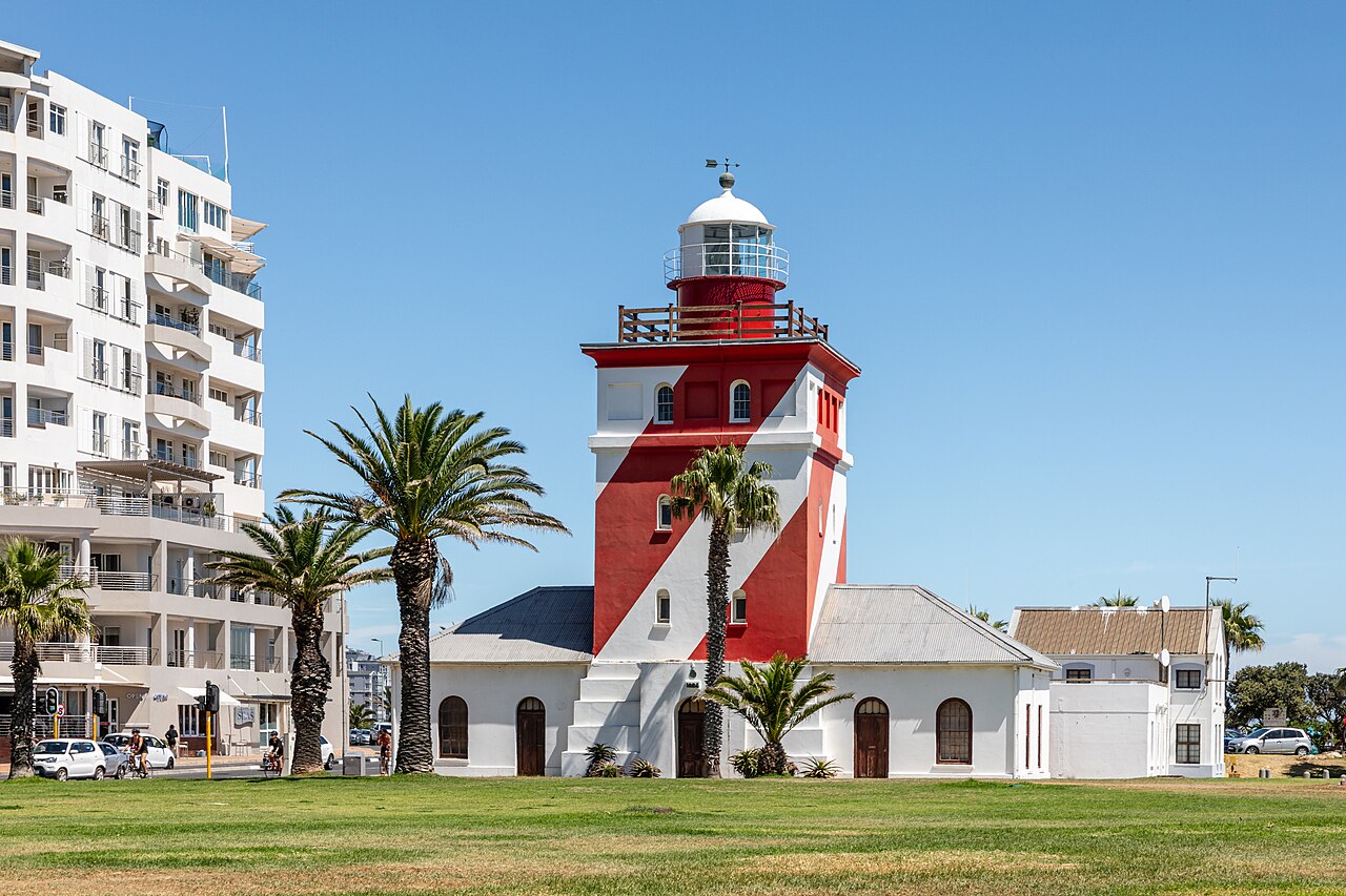
Image context: the cover uses Ermell's 2024 Wikimedia Commons photograph of Green Point Lighthouse itself. It is a real documentary image of the endpoint and recognition cue for this route, not a skyline, route map, or generic Cape Town mood image.[8]
The Ritual: After-Work, Not After-Dark
The best ordinary window is roughly 16:30-18:30 in fair weather, adjusted earlier in winter and later in high summer. That window is an inference from the route's mechanics: you get active local traffic, softer light, enough time to reach the lighthouse, and a choice to stop before Cape Town's night-walking boundary becomes the main story.[5][6][7] A recent r/capetown thread about walking from the Waterfront toward Sea Point is blunt in the way local advice often is: daytime promenade walking is considered doable and beautiful, while several replies draw the line at night walking.[7] Treat that as operational information, not fear copy. Go when the path is populated; finish while the route still feels public.
Begin around the Sea Point side if you want the walk to build toward a landmark. Cape Town Tourism's promenade map gives the recognition sequence: Beach Road and Main Road frame the corridor, while the public playground, Mandela Glasses, outdoor gym, Graaff's Pool, Milton Beach, Up Cycles, putt-putt, the Blue Train Park, and the Mouille Point/Green Point lighthouse are the visible prompts along the way.[2] You do not need to use all of them. Their value is orientation. If you can name the next small object, you are not just wandering along water; you are reading the edge of the city in short, usable segments.
The lighthouse is the right turning point because it carries more than photo value. The City of Cape Town's coastal heritage material says Green Point Lighthouse was commissioned in 1824, the first formal lighthouse built on the South African coast; before that, fires or lamps warned ships of hazards, and the lighthouse later changed height, optics, electrification, and colour to remain visible.[3] That history changes the walk's scale. The red-and-white tower is not a seaside prop. It is a navigational object that made Table Bay safer, and it still gives the promenade a local anchor that is older than the leisure culture around it.
At the lighthouse, do the local thing and choose. If the wind is up or the sky is closing, turn back along the water while the path is still busy. If there is daylight and you want green space, cross toward Green Point Park. CapeTownMagazine's current local guide, updated 1 December 2025, gives the park's practical limits: daily 07:00-19:00, free entry, three play areas, shaded seating that fills quickly on weekends and public holidays, and a Park Cafe open 08:00-17:00.[4] It also notes the biodiversity garden's 300+ indigenous plant species and the looped paths around the central dam, so the park makes sense as a short decompression loop rather than a vague add-on.[4]
Local Moves That Make It Work
- Use the lighthouse as the endpoint before you start. The route stays clean because the striped tower is a visible stop, not because you are trying to cover every attraction between Sea Point and the Waterfront.[2][3]
- Walk in the populated daylight shoulder. The after-work window gives you local movement and better light; late-night completion turns a pleasant walk into a safety calculation.[5][7]
- Stay on the promenade instead of cutting inland too early. A local Reddit reply says the Green Point Park shortcut is shorter from the Waterfront side, but the promenade is the more beautiful walk toward Sea Point.[7]
- Let the wind decide your direction. If the south-easter is stiff, make the route shorter and end near a pickup point rather than forcing a full out-and-back along exposed water.
- Use Beach Road and Main Road as your escape rails. If weather changes, you are never deep in a trail system; rideshare, MyCiTi stops, cafes, and hotels sit close behind the promenade corridor.[1][2][5]
- Sit where the path widens, not in the traffic line. Benches, lawns, and playground edges are for stopping; the central path belongs to walkers, runners, scooters, prams, and cyclists.[2][6]
- Treat Green Point Park as a second room, not a required sequel. It is free and useful, but its 19:00 close and weekend seating pressure mean it works best when you arrive with daylight and patience.[4]
- Keep the route non-beach-minded. Sea Point is rocky, tidal, and promenade-first; Wander Cape Town notes the beaches and tide pools can be enjoyable, but the real everyday value is walking, watching, and using the public edge well.[6]
Non-Local Trapline
Mistake 1: treating the walk as a Waterfront commute. The better move is to make the promenade itself the point. If your only goal is to get from the Waterfront to a Sea Point restaurant, you will rush past the useful part of the route.[5][7]
Mistake 2: starting too late because the area feels busy. The better move is to enjoy the public hour and finish before darkness changes the risk calculation. Local community advice repeatedly distinguishes daytime walking from night walking.[7]
Mistake 3: trying to make the lighthouse, park, Waterfront, and a full Sea Point dinner all one seamless route. The better move is to choose a two-anchor frame: promenade plus lighthouse, with Green Point Park only if the timing still fits.[1][4][5]
Mistake 4: assuming a flat route means no logistics. The better move is to check wind, shoes, daylight, and return plan. A flat, open Atlantic edge can still be unpleasant if you walk it into a headwind with no exit plan.
Concrete Go Details
- Best time window: 16:30-18:30 in fair weather, pulled earlier in winter or whenever sunset and safety margins demand it.[5][6][7]
- Route shape:
Sea Point Promenade -> Beach Road edge -> outdoor gym / public art / pool cues -> Green Point Lighthouse -> optional Green Point Park loop -> return or Waterfront transfer.[1][2][4] - Expected spend: R0 for the walk and Green Point Park; optional cafe or ice-cream money if you stop, with CapeTownMagazine listing Park Cafe examples such as R35 cappuccinos and R65 toasted sandwiches.[4]
- Queue/reservation reality: no booking for the walk or park; the practical bottleneck is weekend seating, path congestion, wind, and whether you begin too close to dusk.[4][5][7]
- Where to stand or sit: stop at widened edges, lawns, benches, or the lighthouse side; do not freeze in the middle of the shared path when runners and scooters are moving through.[2][6]
- Navigation cue: keep the ocean on your outside shoulder and Beach Road behind the promenade; if you lose the lighthouse, re-find the red-and-white tower rather than drifting inland.[2][3]
- Numeric anchors worth keeping: 1824, 16:30-18:30, 07:00-19:00, 08:00-17:00, 300+ plant species, R0, R35, R65, and a roughly one-hour end-to-end promenade walk depending on pace and stops.[3][4][6]
The small win is restraint. Cape Town's dramatic settings invite overplanning, but this one works because it is ordinary enough to repeat: walk the public edge, let the lighthouse make the turn visible, and leave the bigger itinerary for another day.
Sources
- Cape Town Tourism, "Your Neighbourhood Guide to Green Point" (official tourism guide used for Green Point's relationship to the Waterfront, bike/walk framing, and promenade access).
- Cape Town Tourism, "Pocket-Friendly Sea Point Promenade Map" (official map used for Beach Road/Main Road orientation and promenade landmarks including the lighthouse, Blue Train Park, outdoor gym, Graaff's Pool, Milton Beach, Up Cycles, and public playground).
- City of Cape Town, Beaches: A Diversity of Coastal Treasures (official coastal heritage PDF used for Green Point Lighthouse's 1824 commissioning and first-formal-lighthouse context).
- CapeTownMagazine, "The gems of Green Point Urban Park" (local guide updated December 1, 2025; used for current park hours, free entry, seating pressure, cafe examples, playgrounds, and biodiversity-garden details).
- Cape Town Insider, "Sea Point vs Green Point: Where Should You Stay?" (local comparison used for geography, walkability, promenade character, Waterfront proximity, and the Green Point/Sea Point distinction).
- Wander Cape Town, "Sea Point | Neighbourhood Guide to Cape Town's central coastal hub" (local guide used for promenade rhythm, one-hour walking frame, outdoor gym, birds, tide-pool boundary, paragliding, and sunset texture).
- Reddit / r/capetown, "V&A Waterfront" (recent community advice thread used for the daytime-vs-night walking boundary and local route preference between the Waterfront, Green Point, and Sea Point).
- Wikimedia Commons, "File:Cape Town (ZA), Green Point Lighthouse -- 2024 -- 3569.jpg" (documentary photographic source page for the cover image by Ermell, photographed March 2, 2024).