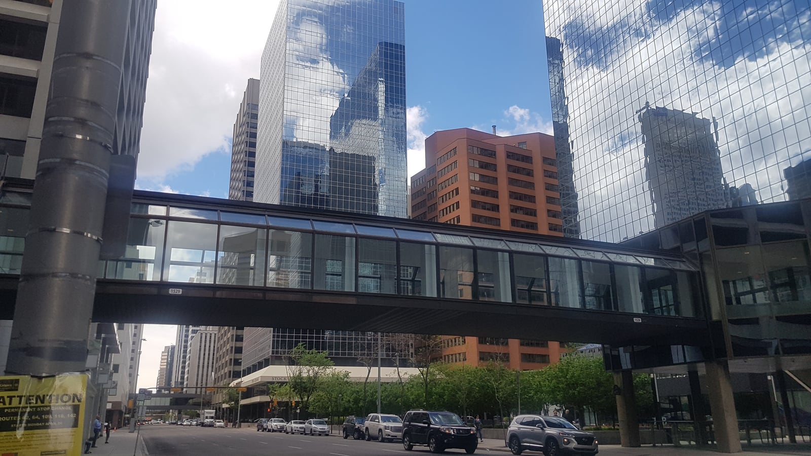
At 11:35 on a weekday, stand on 5 Avenue SW beneath the glass bridge between Fifth Avenue Place and Bow Valley Square. Do not enter yet. Cars hold the street; mirrored towers hold the sky; a fluorescent-lit corridor crosses between them. Calgary's second pedestrian level makes sense only when you first see it from the level it avoids.
Then go upstairs and let noon arrive.
The +15 is not one attraction. It is 86 bridges, more than 16 kilometres of weather-protected walkway, and connections through more than 100 buildings [1][3]. Its name records the intended height—roughly 15 feet above the road, usually at the second floor [4]. At lunch, that planning abstraction becomes a local ritual: office doors open, quiet links acquire a current, and downtown briefly seems to move one storey above itself.
Keep this first encounter tight. Use the +15 as anchor one, following the signed chain from Bow Valley Square through Brookfield Place into TD Square/The CORE. Then climb to Devonian Gardens for anchor two. The direct movement is short; allow 45–60 minutes because the point is to read the handoff, not race it. Ordinary access publishes no admission ticket or reservation, so required spend is C$0 [7].
This is also a route for the present, not a promise that every link will always behave as mapped. On July 18, 2026, the City's live page lists closures at the Suncor–Hanover bridge, the links to Place 800, and the links to 640 Fifth; none belongs to this short spine, but the table can change [1]. Check it on the day you walk.
Anchor one: join the lunch current
Move one: begin under the bridge, not inside it. The photographed crossing over 5 Avenue gives the network a recognition cue: Bow Valley Square is on one side, Fifth Avenue Place on the other [14]. Look up long enough to understand the basic bargain. The +15 removes wind, ice, crossings, and traffic conflict by moving the pedestrian route into buildings. It also removes some pedestrians from the street. Both effects are visible in one frame.
The system's prehistory is more Calgary-specific than the usual cold-weather explanation. The City's history starts the +15 in 1969, while its policy identifies the first official bridge between the Westin and Calgary Place over 4 Avenue SW [1][4]. The network grew building by building rather than arriving as a single sealed megastructure. That is why its interiors keep changing character: office atrium, narrow bridge, retail floor, marble lobby, back corridor.
Move two: photograph the current map before trusting the signs. The official map gives the useful chain: Bow Valley Square -> Brookfield Place -> TD Square/The CORE [2]. Follow building names before cardinal directions. A turn can feel like north while an escalator quietly reverses your orientation. The City itself says the network can be confusing and is installing a new wayfinding system in stages [3]. Getting briefly lost is common; wandering through an unmarked office floor is not the remedy.
If the signed public entrance at Bow Valley Square is unavailable, do not tailgate an employee or argue with a locked door. Return to street level and use Brookfield Place as the practical re-entry shown on the official route map [2]. Privately managed buildings form the public route, so an open bridge does not turn every adjacent lobby into visitor space.
Move three: arrive early enough to watch the tempo change. Heritage and tourism accounts both describe the midday pulse: some links can be empty, then burst into life around noon, while Devonian Gardens fills with downtown workers at lunch [8][11]. At 11:35, you can still look through a bridge without becoming the obstruction in it. By 12:00, the same corridor is doing transport work.
The local convention is simple: slow on the right, pass on the left, and step fully into an atrium before checking your phone. That phrasing comes from community feedback gathered for the network, not from a traffic bylaw [13]. Treat it as courtesy. A glass bridge is the worst place to stop three abreast for a skyline photograph; its width is circulation space, not a viewing platform.
Move four: let each threshold announce itself. From Bow Valley Square, follow the signed connection south into Brookfield Place, then continue south across 7 Avenue into TD Square. The official map marks places with no elevator access to the street, stairs-only connections, accessible washrooms, transit, and building-level discontinuities because “indoors” does not mean uniform [2]. Notice the floor material, ceiling height, temperature, and sound change at every property line. The network is one route assembled from many owners' rooms.
That patchwork is the city-specific texture. A conventional street tells you where public space ends with a curb or doorway. The +15 makes the boundary softer but not absent. The map itself says loitering is not permitted [2]. Keep moving in the bridges; pause only where seating or an atrium clearly invites it. Calgary has built a pedestrian ecosystem, not a 16-kilometre indoor promenade for unrestricted lingering.
Move five: treat the closure page as part of navigation. Official network hours are 6:00–21:00 on weekdays and 9:00–19:00 on weekends and statutory holidays, with Christmas Day closed, but individual bridges may keep shorter hours [1]. Those broad hours do not guarantee the destination. The CORE currently opens 10:00–18:00 Monday through Saturday and 12:00–17:00 Sunday [6]. A 7 a.m. +15 walk can therefore be valid while Devonian Gardens remains inaccessible.
This mismatch is why noon is the right first reading. It is neither an empty architectural tour nor an after-hours door test. You are borrowing a functioning route at the moment Calgarians use it most.
Anchor two: let the garden interrupt the route
Move six: at TD Square, stop following +15 height. Devonian Gardens is not another second-floor bridge. The CORE's access guide places the gardens on Level 4 through the food court, and the City's page gives the address as fourth floor, 317 7 Avenue SW [5]. Follow the garden signs upward. A local Calgary guide notes one small trap: the nearby elevator button may be marked “P”, with “Devonian Gardens” written above it [9]. Read the label before assuming you have the wrong lift.
The change in vertical logic is the whole payoff. For several bridges, movement has been narrow and directional. Then a lift or escalator releases you into 2.5 acres—about one hectare—of indoor public garden with more than 550 trees, 50 plant types, ponds, a play area, and bistro seating [5][15]. The +15 has carried a workday current through private buildings; the garden gives that current somewhere civic to settle.
Move seven: choose whether you want the ritual or the seat. To watch office Calgary arrive, reach the garden between 11:45 and 12:05. To sit with less competition, use 10:30–11:30 or arrive after 12:45. Tourism Calgary explicitly recommends before or after weekday lunch for a quieter visit, while local guidance warns that lunchtime tables can be difficult to find [8][9]. These are patterns, not guarantees.
If you arrive at noon, do not patrol occupied tables waiting for somebody to stand. Walk one slow circuit first. Keep the play area for families, keep bags off spare chairs, and take the first clearly available bistro seat rather than hunting for an imaginary “best” corner. Bringing a small lunch is normal; the food court is on the same level, but buying from it is not part of this route [5][9].
Move eight: look for the faces before looking for wilderness. More than 30 burl-wood carvings by Calgary artist Tom Ward have lived in the gardens for over 40 years. A March 2026 City account says Ward's family loaned them in 1986 on a handshake; he carved about 200 masks from Alberta pine and spruce burls between the late 1960s and 1984 [12]. If the current display is visible, let one face hold your attention. The carvings give this bright mall-top garden a resident memory that tropical foliage alone cannot.
They also correct a visitor's scale. Devonian Gardens is not a substitute for the Rockies, a botanical collection demanding half a day, or a secret forest untouched by redevelopment. Recent community reviews repeatedly describe it as a place to have lunch, read, work, or recover after shopping [10]. That modest scale improves the visit. The garden is strongest as the end of the +15 ritual, where the city's circulation system briefly grows trees and asks workers to sit.
Move nine: leave at street level. After 20–30 minutes, descend through The CORE and exit toward 8 Avenue/Stephen Avenue. Do not reverse the whole route by default. The final move is to feel weather, crossings, and street frontage return. Look back at the bridges only after you are outside. The +15 is clearer when the street gets the last word.
The visitor trapline
Mistake one: treating the +15 map as a guarantee. Construction closures, emergencies, property hours, and locked internal doors can break a printed line [1][2]. Better: check the live City table immediately before leaving, save the current map, and accept a street-level detour instead of forcing access.
Mistake two: walking at noon as if the bridges were observation decks. The ritual is compelling because the network is busy, not because it becomes a museum. Better: keep right, pass left, and move photographs into atria or street level [13].
Mistake three: assuming +15 hours and garden hours are the same. The network begins earlier and ends later than The CORE, especially on Sundays [1][6]. Better: use a weekday arrival around 11:35, when both anchors are open and the lunch handoff is beginning.
Mistake four: overselling Devonian Gardens as a standalone conservatory. Local guides and community reviews frame it as a lunch-hour or shopping-break room [9][10]. Better: spend 20–30 minutes, use it as a free civic pause, and let the route into it supply the meaning.
A compact go plan
- Best window: weekday 11:35–12:45 for the full lunch ritual; 10:30–11:30 for a calmer version [8][9].
- Expected spend: C$0 required. Devonian Gardens appears in Tourism Calgary's current free-things guide, updated July 17, 2026 [7].
- Queue and reservation reality: no timed entry is published for ordinary +15 or garden access; the practical scarcity is a garden seat at lunch, not an admission slot [7][9][10].
- Navigation cue: start beneath the Bow Valley Square–Fifth Avenue Place bridge on 5 Avenue SW, then follow
Bow Valley Square -> Brookfield Place -> TD Square/The CORE -> Level 4 Devonian Gardens[2][5][14]. - Where to move and sit: keep right in links, pass left, stop in atria, then use any clearly open bistro seat in the garden without claiming extra chairs [5][13].
- Time budget: reserve 45–60 minutes total, including 20–30 minutes in the garden. The indoor approach varies with pace, access, and wrong turns; add time rather than forcing a closed link.
- Same-day check: live bridge closures, individual door signs, The CORE hours, lift availability, and any garden event footprint [1][2][6].
Calgary's +15 is often explained as an answer to winter. At noon, it becomes something more revealing: a daily agreement about how to share a city built inside other buildings. The bridges ask you to move. The garden permits you to stop. The street waits below both. Use all three in that order and downtown's strangest habit becomes legible.
Sources
- City of Calgary, “Plus 15 network – Calgary's Skywalk” — live operating hours, current closure alerts, 1969 origin, 86 bridges, and network length.
- City of Calgary, Plus 15 Skywalk Network Map (March 2026) — current building chain, access symbols, amenities, closures, and network etiquette.
- City of Calgary, “Plus 15 Wayfinding Improvements” — 100-plus connected buildings, documented navigation difficulty, network scale, and staged signage work.
- City of Calgary, Plus 15 Policy — official height/name explanation, second-floor norm, bridge composition, and first-bridge location.
- The CORE Shopping Centre, “Tourist Information” — current street, CTrain, +15, and Level 4 Devonian Gardens access.
- The CORE Shopping Centre, “Hours” — current Monday–Saturday and Sunday access windows.
- Tourism Calgary, “Free Things to Do in Calgary” (published July 7 and modified July 17, 2026) — recent confirmation that Devonian Gardens remains free.
- Tourism Calgary, “Devonian Gardens” — local destination guidance on the garden's weekday lunch rhythm and before-or-after timing.
- Calgary Playground Review, “Devonian Gardens and Playground” (updated June 25, 2025) — local guidance on the Level 4 elevator label, lunchtime seating, food, and same-floor layout.
- Loc8NearMe, “Devonian Gardens” reviews (including April–May 2026 reports) — recent visitor confirmation of tables, natural light, lunch use, and the same-level food court.
- Heritage Calgary, “Calgary's Plus 15 System” (May 5, 2025) — local history and observation of corridors changing from near-empty to busy around noon.
- City of Calgary Newsroom, “Devonian Gardens the forever home for wood carvings created by beloved Calgarian Tom Ward” (March 5, 2026) — the masks' maker, materials, loan history, and long residence in the gardens.
- City of Calgary, Plus 15 Network: What We Heard Report (May 2018) — community feedback on crowding, movement conventions, and navigation difficulty.
- Wikimedia Commons, “Calgary - Plus 15.jpg” — Mule hollandaise's 2020 documentary photograph of the Bow Valley Square–Fifth Avenue Place bridge used as the article image.
- City of Calgary, “Devonian Gardens features” — current official details on acreage, trees, plant types, ponds, play space, and bistro seating.