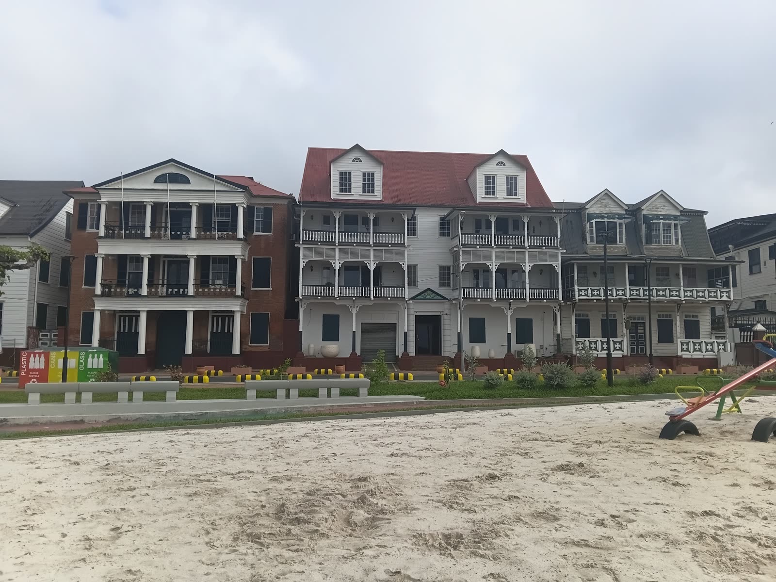
Walk only the renewed section of Paramaribo’s Waterkant and the city keeps changing the meaning of “arrival.” The broad Suriname River brought trade and colonial power. It was also the edge where enslaved Africans were landed and sold. Today, new paths, grass, benches, play space, and an amphitheater ask that same edge to work as ordinary civic ground.
The useful route is deliberately short: begin outside De Waag, move east through the renewed riverfront and Old Flag Square, and finish at the exterior of Fort Zeelandia. It is roughly 550 metres one way, or about 1.1 kilometres if you retrace it [9]. Allow 60–90 minutes. The opening sources describe public access, not a ticketed attraction or reservation system, so the public-space and fort-exterior version requires no purchase; transport, water, vendors, and museum admission remain separate [2][3][5].
Use 16:30–18:15 as an editorial comfort window, not an official opening time. Paramaribo’s climate is hot year-round, the first reopening drew crowds toward the almond shade, and a June 2026 local report described evening noise among the waterfront’s management problems [3][8][10]. Late afternoon avoids the hardest light while keeping the route short of late evening. The architectural fallback is 07:15–08:45.
The renewed Waterkant opened to the public in two stages: the first section on September 13, 2025, then the second on November 22 [2][3][4][5]. That makes this a rare moment when a visitor can see an old urban argument on visibly new ground. Do not spend it collecting landmarks. Two anchors are enough: the renewed Waterkant, with Old Flag Square inside it, then the fort at its eastern end.
Anchor one: the renewed Waterkant
First move: find the western edge outside De Waag, then leave it. The building is easy to turn into a restaurant decision; that would make the route about a meal before it has begun. Stand on the Waterkant side, orient east toward Fort Zeelandia, and first read the opposite row of timber buildings. The project’s own boundary defines the Waterkant as the river edge between De Waag in the west and the fort in the east [1]. De Waag is a coordinate, not a stop or third anchor.
The facade line has survived discontinuity rather than time standing still. A European trading post was established in 1613 near the Indigenous settlement recorded as Parmurbo or Permermba. By 1683, the Waterkant and Gravenstraat held 27 houses and were expanding as the settlement’s working core. Fire destroyed many riverfront houses in 1821; the wooden galleries rebuilt afterward became part of the streetscape visible today [1]. Across the historic centre, UNESCO now counts 291 listed monuments within a street plan that still expresses the city’s Dutch colonial structure and its adaptation to local materials and climate [7].
Second move: cross at the clearest marked pedestrian point you can see. Before redevelopment, drivers on the curve near Old Flag Square were observed at up to 50–60 km/h even though the area’s posted limit was lower. The project design specified traffic-calming plateaus that would double as pedestrian and cycle crossings, but a 2026 local report said stop rules were not always observed [1][10]. Current markings and traffic outrank the plan. Wait, look both ways, and keep phones down until you are on the river side.
Read the project promise against current conditions
Third move: take the river path, but keep a passing line open. The redevelopment design specified nearby pavements at 4–6 metres, a 3–3.5-metre landscaped footpath, and a reduction in Waterkant road parking from 32 spaces to 12 [1]. Treat the measurements as design specifications, not a 2026 as-built survey; their intended trade is what matters—more walking room and less parked metal between the houses and river.
A June 2026 STVS report, attributing concerns to Dagblad De West, said bicycles and mopeds were using footpaths and also described unclear management responsibility, litter, damaged furniture, and weak green maintenance [10]. These are reported conditions, not proof that every metre is degraded. Keep right, look behind before moving sideways for a photograph, and do not confuse visual width with exclusive pedestrian use. Then stop at one bend and look back across the road: the revealing frame holds brown river, new public surface, traffic line, and wooden galleries together.
Fourth move: let the surviving almond shade determine the pause. The pre-work baseline counted 24 almond trees along the riverside, plus 17 mahoganies concentrated near the fort and 16 tamarinds around Independence Square [1]. Those are not current tree counts. The design planned to retain most almonds, and local reporting at the first reopening observed older visitors seeking their familiar shade while younger people photographed the quay [3]. That is a better cue than the most photogenic empty bench: if one shaded seat is already doing social work, choose another and preserve its everyday use.
This attachment was measured before it was landscaped. The project’s 65-person field-interview sample included craft sellers, food vendors, workers, residents, businesses, agencies, and educational institutions. About 25% of respondents said the Waterkant had religious, spiritual, or other special meaning; their examples included the waterfront’s connection to ancestors and the almond trees themselves [1]. That does not make every bench sacred, and it does not establish a single community view. It does mean “nice new park” is too thin a description.
Fifth move: use the facilities as a reset, not a destination. The renewed area includes a craft-market structure, public toilets, seating, and play space [1][3]. Availability can change, so do not build the walk around a toilet being unlocked or a stall operating. If facilities are open, pause there, refill your attention rather than your itinerary, and continue east. Keep the primary walk non-food; vendors are part of the Waterkant’s working life, not required purchases in a scripted tasting route.
Let Old Flag Square change the Waterkant’s meaning
Sixth move: give Old Flag Square ten seated minutes. The new amphitheater was designed for cultural use and reported with capacity for up to 200 people [1][3]. When nothing is programmed, its stepped form can look like neutral landscaping. It is more useful to face the river and ask what kind of public is being assembled there—and what histories made that assembly difficult.
The quay was a place for loading and unloading because the river gave ships room to manoeuvre. Colonial commerce also made it a site of forced arrival: enslaved Africans landed here and were sold to plantation owners until formal abolition in 1863 [1]. At the full reopening in November 2025, Indigenous and Tribal representatives performed a plengoffer, an offering ceremony; in the same ceremony, the vice president framed the Waterkant as a place where many ancestors first set foot in Suriname [2]. The ceremony does not resolve the waterfront’s history or make one official narrative sufficient. It changes how a careful visitor should use the amphitheater: not as a generic front-row seat for sunset, but as a place where civic return and coerced arrival occupy the same river edge.
Seventh move: keep one patch of new paving and one old line in view. During the works, excavation exposed a shell-stone quay wall laid in 1841, roughly 20–30 centimetres below the present surface. The wall originally ran from the Steenen Trap toward De Waag; the project documented it and proposed marking its line in contrasting pavement [6]. Do not hunt behind barriers or step into planted areas looking for masonry. Read the surface that is available. If a contrasting straight band is visible, follow it with your eyes; if it is not, the discovery still explains why apparently fresh paving belongs to a much older engineered shore.
Anchor two: Fort Zeelandia’s exterior
Eighth move: stay on the river side until the route reaches the fort approach. The project design linked its footpaths toward Fort Zeelandia, and the current pedestrian routing connects the same endpoints [1][9]. Follow that line instead of drifting north into Independence Square or continuing toward Waka Pasi. Both may deserve separate visits, but adding them dissolves the close read. As the route bends, the fort’s low, heavy geometry replaces the vertical rhythm of wooden houses.
The fort is not simply a photogenic endpoint. It became the colonial settlement’s military and administrative nucleus, and the planned street grid spread from it from 1683 [7]. From the exterior, turn back west once. De Waag will no longer read as a restaurant-shaped starting point; it becomes the other end of a controlled urban edge, with commerce, defence, forced movement, memory, and recreation compressed between.
Ninth move: finish outside unless the museum was already a separate plan. Museum access, admission, and exhibitions can change, so verify them directly on the day you intend to enter. The outdoor route works without museum access. If the current conditions fit, enter as a new visit with its own clock. Otherwise, use Zeelandiaweg as the exit and leave the riverfront before dark. The point of a firm stop is not caution dressed as austerity; it protects the two-anchor scale that made the Waterkant readable.
The visitor trapline
Mistake one: reading “renewed” as “finished and self-maintaining.” Fresh grass and paving can produce a before-and-after story in which 2025 fixed an empty waterfront for good. Local reopening coverage described crowds reclaiming the space, but newer local reporting raised unresolved management and maintenance concerns [3][10]. Better: notice both the civic investment and the wear, without turning either into the entire story.
Mistake two: assuming a wide path is pedestrian-only. Reported bicycle and moped use makes an unannounced sideways step a poor way to frame a photograph [10]. Better: keep a predictable line, check behind you, and move to the edge before stopping.
Mistake three: arriving at noon because the route is short. Paramaribo’s climate normals put average monthly daily maxima above 31°C throughout the year, while local reopening coverage records how quickly visitors reclaimed the almond shade [3][8]. Better: use 16:30–18:15, or take the architecture-first fallback of 07:15–08:45. Carry water and a compact rain layer in either window.
Mistake four: treating late afternoon as an open-ended museum-and-night walk. Recent local reporting flags evening noise on the Waterkant, while public-space access says nothing about museum access [10]. Better: make the fort exterior the guaranteed endpoint; schedule the museum separately after a direct same-day check, and finish the public-space read before late evening.
A compact go plan
- Best window: 16:30–18:15, with 07:15–08:45 as the quieter heat-avoidance alternative. Finish in daylight.
- Expected spend: 0 SRD in required purchases for the public-space and fort-exterior route. Carry local currency for transport, water, or an optional vendor; the museum is separate [2][3][5].
- Queue and reservation reality: the opening sources describe ordinary public access and publish no outdoor reservation mechanism. A programmed amphitheater event or museum visit can have different controls [2][5].
- Navigation cue:
De Waag exterior -> clearest marked crossing -> riverside path -> Old Flag Square amphitheater -> Fort Zeelandia exterior[1][9][10]. - Where to stand and sit: stand on the river path where the water and facade line share one frame; sit for 10 minutes in the amphitheater without blocking a programmed area; take the final look west from the fort approach.
- Distance and time: about 550 metres one way, 1.1 kilometres out and back, and 60–90 minutes at reading pace [9].
- Same-day check: weather, current sunset, visible crossing instructions, path traffic, any event footprint, public-toilet access, and direct museum confirmation only if you plan to enter [10].
The Waterkant’s renewal is easiest to misunderstand when it looks most finished. Its value is not that the new surface hides an untidy past. It is that, in one compact line, the surface makes several Paramaribos occupy the same view: Indigenous ground, colonial port, forced-arrival shore, wooden city, remembered shade, and a public space handed back into daily use. Walk it slowly enough and the river stops being scenery. It becomes the reason the street is there.
Sources
- Paramaribo Urban Rehabilitation Program, Environmental and Social Impact Assessment for the Redevelopment of the Waterfront and Improvement of the Surrounding Mobility Infrastructure (updated final report, May 2024) — project boundary, history, design dimensions, traffic, trees, interviews, and facilities.
- Government of Suriname, “Waterkant in vernieuwde glorie opgeleverd” (November 22, 2025) — official second-section delivery, reopening ceremony, vice-presidential framing, and plengoffer.
- Starnieuws, “Gezellig druk bij heropende Waterkant” (September 14, 2025) — local reporting on the first section, public facilities, amphitheater capacity, and early visitor use.
- Starnieuws, “Herboren Waterkant moet aanjager worden van een vernieuwd historisch Paramaribo” (November 23, 2025) — local reporting on completion, Surinamese design and execution, and officials’ management, safety, and maintenance plans.
- Waterkant.net, “Vandaag opening tweede deel van de vernieuwde Waterkant” (November 22, 2025) — a second local channel confirming the final-section opening and project sequence.
- Paramaribo Urban Rehabilitation Program, “Oude kademuur van Waterkant ontdekt” (October 1, 2024) — documentation of the 1841 shell-stone quay wall, its depth, extent, and proposed surface marking.
- UNESCO World Heritage Centre, “Historic Inner City of Paramaribo” — official statement of significance, urban-grid history, boundaries, and listed built heritage.
- World Meteorological Organization World Weather Information Service, “Paramaribo” — official climate normals for temperature and rainfall.
- OpenStreetMap, pedestrian directions from the De Waag end of Waterkant to Fort Zeelandia — route geometry and walking-distance check.
- STVS, “Waterkant kampt maanden na opening met beheer- en onderhoudsproblemen” (June 15, 2026) — recent local reporting, attributed to Dagblad De West, on path conflicts, traffic behavior, evening noise, maintenance, and unresolved management.
- Wikimedia Commons, “Paramaribo 2026 - 13.jpg” — Ginmardo’s CC BY-SA 4.0 photograph of the renewed Waterkant and historic buildings, made March 26, 2026.