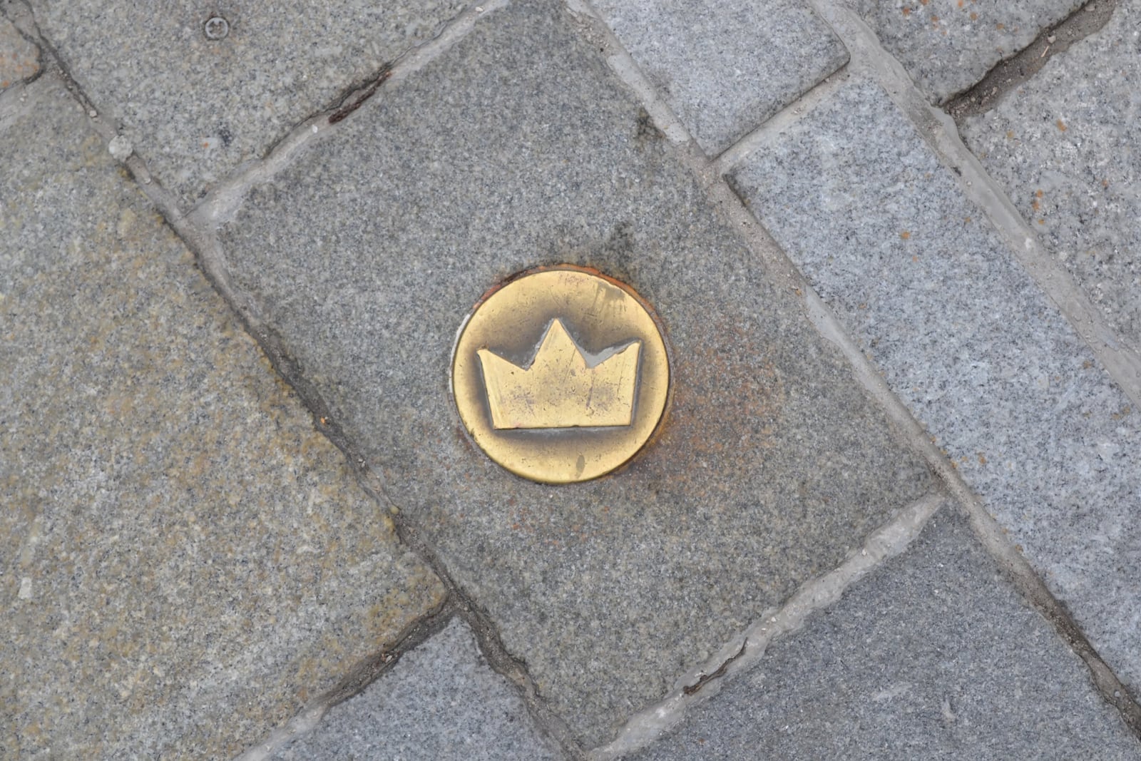
Bratislava keeps one of its grandest histories in a place where rain, pram wheels and morning foot traffic can pass over it. A small brass crown lies flush with the paving. Then another appears farther along. There are 178 of them between St Martin's Cathedral and Michael's Gate, each reducing a royal procession to a sign no larger than a palm [1][2].
The cleanest way to read them is not as decoration and not as a scavenger hunt. Give the crowns 60–75 minutes on a dry Monday-to-Saturday morning, beginning at St Martin's at 09:00. Walk the marked direction through the old town, one confirmed turn at a time. The route itself costs EUR0, needs no reservation and has no queue. Its difficulty is attention: the object asks you to look down, while the city still requires you to look ahead.
This is a one-object visit with one secondary cue. The repeated pavement crown is the anchor; the gilded crown 85 metres above it on the cathedral tower tells you where to begin [4]. Between those two scales—shoe sole and skyline—Bratislava's coronation past becomes legible without turning the old town into a royal checklist.
Begin beneath the crown you cannot miss
The first local move is to save the right starting point: Dóm sv. Martina, Rudnayovo námestie 1. Do not type “coronation route” into a map and accept whichever tourist pin appears first. If arriving by public transport, use the current Most SNP stop page rather than memorising a line number; the local transport database was carrying September 2026 service changes when this article was prepared [7]. Bratislava Region's visitor page directs public-transport users to Most SNP and gives Kapitulská as the useful pedestrian approach from the old town [8].
The second move is to arrive at 09:00, not because the crowns have opening hours—they remain outdoors—but because that is the start of the cathedral's published 09:00–11:30 morning visitor window from Monday through Saturday [4]. Look inside only if the door and the day's worship schedule permit it. St Martin's is a working church, not the reception desk for the pavement trail: the parish explicitly suspends tourist visits during liturgies, baptisms, weddings and concerts [13]. Google Maps supplies a useful last-metre location and live-status check, but its crowd-updated hours should not outrank the church's door and published visitor window [4][10]. Ten quiet minutes is enough; a service or closure is an instruction to stay out.
Inside or out, establish the historical sequence before walking. From 1563 to 1830, St Martin's served as the coronation church for rulers of the Kingdom of Hungary and their consorts [2][4]. Bratislava was then widely known as Prešporok in Slovak and Pressburg in German. The city's present-day account still uses Prešporok when it retells Maria Theresa's coronation, a useful guardrail against projecting today's national borders and names backward [5]. These were Hungarian coronations held in this city, not coronations of “Slovak kings.”
Now make the third move: look up once, then down. Find the gilded crown on the tower. At pavement level, match the small stylised crown in the photograph above: pale brass inside a round metal plate, set into darker stone [12]. Do not assume every shiny disc belongs to the route. Once you have identified one correctly, the repeated object becomes much easier to recover after a crowded patch.
Use each crown as a confirmation, not a command
Before leaving Rudnayovo námestie, save the tourist board's coronation map to your phone. It shows the marked old-town section and states the count of 178 crown-shaped brass plaques [1]. That is the fourth move, and it changes the walk. The crowns can confirm that you remain on the thread; they should not force you to stare at the ground while crossing a lane or negotiating uneven paving.
The historical order is precise. After the church ceremony, the newly crowned ruler left through the cathedral's north portal and proceeded along Kapitulská, Prepoštská, Ventúrska and Sedlárska, across Hlavné námestie and Františkánske námestie to the Franciscan church [2][3]. From there the procession continued through Biela and Michalská toward Michael's Gate [2]. The street names are more dependable at a junction than trying to decide which way the tiny crown's points seem to face.
The fifth move is therefore a rhythm: find a plaque, stop at the building edge, locate the next street name, then walk with your head up until the next safe pause. On Kapitulská, let the quieter old facades supply the atmosphere. On Ventúrska and Sedlárska, expect service activity, café furniture and other pedestrians to break the visual line. A current local walking guide calls the centre compact but specifically recommends trainers for its historic cobbles [9]. The route is not improved by chasing an unbroken chain through somebody else's path.
At Hlavné námestie, make the sixth move and stop looking for crowns for a full minute. During the old ceremony, city representatives greeted the ruler by the town hall. The way ahead had been covered with red cloth or the red-white-green colours of Hungary; after the procession passed, residents tore pieces away [3]. That fleeting material is the revealing contrast. The coronation used fabric, timber stages, soil brought to a ceremonial mound and crowds assembled for one day. The modern city chose brass: durable, weathered and permanently public.
Resume the plaques toward Františkánske námestie. The seventh move is to pause outside the Franciscan church rather than treating the square as a bend in a route. Here the monarch knighted selected men as Knights of the Golden Spur [3]. This was a change of ceremonial status, not simply the next photo stop: consecration in the cathedral had been followed by recognition from the town, then the making of knights. One short walk joined church, city and court.
Continue through Biela and Michalská. Near Michael's Gate, the streets tighten and attention gets divided between shopfronts, people and the tower. Let the map carry the navigation and let a crown merely confirm it. A long-running Geocaching community entry makes the route's most useful boundary explicit: all 178 plaques mark the section that ends at Michael's Gate [11]. The marker series ends; the old ceremony did not.
At Michael's Gate, refuse the false ending
The eighth move is to finish the object walk without inventing an ending for the history. After passing through Michael's Gate, the ruler swore the coronation oath on a stage outside the walls; in later coronations that stage stood in the area of today's Námestie SNP [3][11]. The procession later reached a constructed mound near the Danube, where the monarch rode up and swung the sword toward the four cardinal directions as a promise to defend the kingdom [3][11]. The marked pavement preserves one coherent section—the cathedral-to-gate passage—not the entire day.
That distinction is what makes the crowns more interesting than a heritage logo. A line of markers always edits. It chooses which movement can be traced comfortably through the current street plan, then leaves the walker to recover the missing stages through evidence. Michael's Gate is both a satisfying visual finish and a reminder that public history rarely fits inside its wayfinding system.
The tradition is not dormant. For 2026 Coronation Days, the city scheduled a July 24–26 programme centred on Maria Theresa, including a tournament and a 200-person procession [5]. But an annual reenactment and the everyday brass trail are different experiences. The festival supplies bodies, costumes and spectacle; the pavement supplies scale. On an ordinary morning, no one clears Ventúrska for you. That is precisely why the small crowns work: royal memory has to share the street.
Four ways to lose the thread
Mistake one: beginning at Bratislava Castle because royalty “must” begin there. The 2026 festival procession was scheduled to start at the castle, but the plaque sequence traces the post-crowning section from St Martin's toward Michael's Gate [1][2][5]. Better: begin beneath the cathedral's tower crown, then let the first pavement marker lower the story to walking height.
Mistake two: treating 178 plaques as turn-by-turn navigation. Crowds, furniture, repairs and your own angle can hide a marker, while old paving rewards careful footing. Local and community route sources agree on the street sequence and the Michael's Gate boundary [2][9][11]. Better: save the map, use street names at junctions and make each crown a confirmation.
Mistake three: walking with a phone or camera pointed continuously at the ground. This sacrifices situational awareness on the historic cobbles for which current local walking advice recommends trainers [9]. Better: step to the edge, frame one close photograph, put the phone away and alternate deliberately between paving and facade. The one photograph will be more specific than a roll of nearly identical brass discs.
Mistake four: making the cathedral door the route's failure point. Published hours can yield to services and special events because the building remains an active place of worship [4][13]; community-updated live status is useful as a day-of warning, but it cannot override the church door [10]. Better: keep the interior optional. The outdoor object, the tower crown and the exact street sequence still make a complete walk; return during a currently published visitor window only if entering matters.
The pocket route
- Primary anchor: the 178 brass crowns from St Martin's Cathedral to Michael's Gate; use the gilded tower crown only as the starting recognition cue [1][4].
- Best window: Monday–Saturday, 09:00–10:15, in dry daylight. This aligns the start with the current morning cathedral hours while keeping the walk outdoors if access pauses [4].
- Time needed: 60–75 minutes, including an optional 10-minute cathedral look and two deliberate pauses at Hlavné námestie and the Franciscan church.
- Expected spend: EUR0 for the outdoor route. If you need one public-transport ride within Bratislava zones 100+101, the current 30-minute paper ticket is EUR1.20; the eTicket is EUR1.09 [6].
- Queue and reservation: none for the pavement route. Do not join or interrupt a service to force an interior visit.
- Navigation line: Rudnayovo námestie → Kapitulská → Prepoštská → Ventúrska → Sedlárska → Hlavné námestie → Františkánske námestie → Biela → Michalská/Michael's Gate [2].
- Where to stand: at the building edge whenever you stop to inspect a crown; keep the centre of the lane, thresholds and crossings open.
- Footing: wear stable shoes, avoid rushing on wet stone and review the route in advance if uneven paving presents an access barrier [9].
- Live check: consult the Most SNP stop page on the day; a current local transport source is safer than an old list of route numbers [7].
At Michael's Gate, it is tempting to reward yourself by looking only up. Resist for one last second. Find the final brass sign beneath the tower, then hold both scales together: a crown once placed on a ruler's head, a crown now level with everybody's feet. Bratislava has not made the coronation past smaller. It has made it walkable.
Sources
- Bratislava Tourist Board, Bratislava city guide (2023 edition, PDF), pp. 10–11 — official map and count of 178 crown-shaped brass plaques along the coronation route.
- Danica Janiaková, “Po korunovačnej ceste uhorských kráľov,” Klub 50 — Bratislava-native walking account with the plaque count, exact street sequence, dates and crowned rulers.
- Bratislava Tourist Board, “Coronation Celebrations” — primary local account of the cathedral rite, procession, city greeting, knighting, oath and Danube coronation mound.
- Bratislava Tourist Board, “St. Martin's Cathedral” — current address, visitor hours, working-church context, coronation period and 85-metre tower.
- City of Bratislava, “Kráľovná sa vracia do Prešporka” (June 2026) — recent primary confirmation of the July 24–26, 2026 Coronation Days and the city's present-day framing of Maria Theresa and Prešporok.
- Integrated Transport System in the Bratislava Region, “Single Tickets” — current official paper and electronic fares for a 30-minute journey within Bratislava zones 100+101.
- imhd.sk Bratislava, “Most SNP” — local transport-community stop page with current lines, departures and September 2026 service-change notices.
- Bratislava Region Tourism, “Dóm sv. Martina” — regional visitor listing with the Rudnayovo námestie address, Kapitulská pedestrian approach and Most SNP public-transport arrival.
- Kratkodobeubytovanie.sk, “Bratislava Old Town: What to See on Foot” (updated July 14, 2026) — recent local guide on the compact pedestrian core, crown markers, cobbled footing and practical walking loop.
- Google Maps, “St. Martin's Cathedral” — community mapping and review platform with the current Rudnayovo námestie address, live-status updates and recent visitor reports.
- Geocaching, “Korunovacna cesta / Coronation route” — community route record confirming the 178 markers, Michael's Gate boundary and later oath-and-mound stages.
- Slyronit, “Crown as a symbol of the Coronation Walk, Bratislava,” Wikimedia Commons — CC BY-SA 4.0 documentary photograph of a route plaque used as the article image.
- Parish of St Martin's Cathedral, “Prehliadky katedrály” — primary visitor guidance on tourist hours, worship and concert closures, and individual access zones.