Most visitors read Antwerp from the wrong side of the river. They stay on the historic right bank, collect cathedral and guildhouse views, and treat the Scheldt as background. The cleaner move is to let the river do one piece of work for you. Go down through Sint-Annatunnel at Sint-Jansvliet, cross under the Scheldt, then walk out to Sint-Annastrand on Linkeroever and hold the skyline from there.[1][4][5]
This is a strict two-anchor place portrait, and both anchors are non-food. The tunnel is the arrival chamber. The left-bank shoreline is the release. Antwerp by Bike's local guide is unusually clear on the point: the best skyline view sits on Linkeroever, the tunnel has been running under the Scheldt since 1933, and the walk only makes sense if you keep going from the exit toward the waterfront rather than stopping at the square.[4] The older cultural layer matters too. The 500 Hidden Secrets guide notes that artists have been coming to this side of the river since the 15th century to paint Antwerp's profile, which tells you that this is not a new Instagram trick but a long-standing city habit.[5]
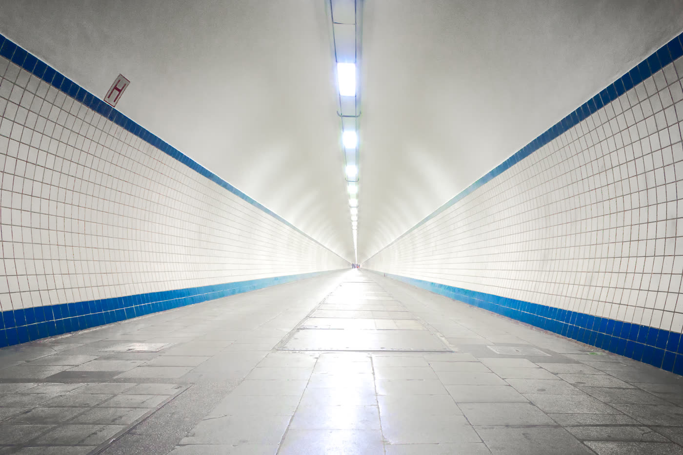
Image context: the cover uses a real Wikimedia Commons photograph of Sint-Annatunnel's wooden escalator. That is the right visual for this piece because the tunnel itself is the recognition cue. Antwerp gets more interesting once you treat this preserved machinery as part of the outing rather than as a shortcut you rush through.[8]
Why this hinge works better than staying on one bank
The tunnel gives the route structure. De Lijn's current page frames it as the pedestrian connection between Frederik van Eedenplein on Linkeroever and Sint-Jansvliet on Rechteroever, accessible by elevator and escalator, and free day and night.[1] The same page says cyclists may pass through only at walking speed, which is one of those small local rules that immediately separates the place from a generic tourist passage.[1]
The infrastructure behind that rule is older and more fragile than most visitors realize. Wegen en Verkeer says the tunnel was built between 1931 and 1933, that both entrances still have authentic wooden escalators, that each lift is rated for 40 people / 3,000 kg, and that the whole complex was protected as a monument in 1997.[2] This is not one more cleaned-up waterfront attraction. It is preserved civic hardware still doing daily work.
That daily work is intense enough to shape how you should behave on-site. Wegen en Verkeer says lift movements peak at more than 25,000 per month in summer, with about 1,200 up-and-down movements on a good weekend day.[2] That is why the best version of this stop is compact. Descend, cross, emerge, and save your longer pause for the river edge rather than clogging the tunnel machinery itself.
The left-bank half also has a built-in fallback. De Lijn's Sint-Anna ferry page says the boat between Linkeroever and Het Steen is free for pedestrians and cyclists, carries up to 150 people, runs every 15 minutes in the daytime and every 30 minutes at night, and operates day and night.[3] That makes the ferry useful as backup or return leg, but not as the primary move here. If the point is to understand Antwerp's river hinge, the tunnel should come first.
Anchor 1: Sint-Annatunnel should feel like a room, not a shortcut
Start on the right bank at Sint-Jansvliet. That side gives you the cleanest sense of descent. Once you step onto the wooden escalator, Antwerp stops behaving like a museum district and starts behaving like a working port city that once solved its river problem with art deco engineering.[1][2][8]
The tunnel is memorable because it stays mechanical. Antwerp by Bike describes it as a 572-metre horizontal cylindrical tube in art deco style, with authentic wooden escalators on both banks.[4] That description matches the experience better than any abstract heritage label. You do not glide through a neutral corridor. You move through a long preserved machine whose surfaces still tell you how old it is.
The local move here is simple: keep the crossing continuous. Do not turn the escalator landing into a photo bottleneck, and do not treat the tube like a place for erratic bike speed or scooter improvisation. De Lijn's own wording is already enough instruction: walking is the norm, cycling is allowed only at walking pace, and some non-standard vehicles are not meant to ride through at all.[1]
Anchor 2: Sint-Annastrand is where Antwerp resolves itself
Once you emerge on Linkeroever, do not stop at the first open space and assume you have arrived. Keep walking toward Sint-Annastrand. Antwerp by Bike says the waterfront beyond the tunnel exit holds the most impressive skyline view, and that short extra walk is what separates a complete route from an incomplete one.[4]
This is where the city clicks. On the right bank, Antwerp's profile can feel busy and frontal. From Linkeroever, it becomes a long edge: cathedral, riverfront blocks, and port-city mass reading as one continuous line. The 500 Hidden Secrets guide treats this left-bank panorama as one of the city's defining views and ties it to a much older tradition of painters crossing the river for exactly this perspective.[5]
Current community-review surfaces still show both anchors functioning as everyday places rather than sealed heritage exhibits. The tunnel remains an active crossing; the riverside remains a place people use to hold the skyline, sit, and wait out the light.[6][7] That continuing use is part of the pleasure. The route feels local because neither half is staged only for you.
8 local moves that materially improve this stop
- Start at Sint-Jansvliet on the right bank if the tunnel is your real first anchor; beginning on the left bank weakens the sense of descent.[1][4]
- Use the wooden escalator down if it is running cleanly, but remember the lifts are there for bikes, strollers, and mobility constraints, with a 40-person rated capacity.[2]
- If you are cycling, switch mentally to pedestrian mode. De Lijn's rule is walking speed, not commuter speed.[1]
- Keep Thursday in mind. De Lijn says the escalators undergo maintenance every Thursday, so budget for a slower entry or lift use on that day.[1]
- Keep the tunnel crossing short and purposeful. The site is heavily used, with more than 25,000 lift movements per month in peak summer and roughly 1,200 lift trips on a strong weekend day.[2]
- Once you surface, do not linger at Frederik van Eedenplein just because the tunnel has ended. The better skyline read is farther out at the river edge near Sint-Annastrand.[4][5]
- Hold the ferry in reserve, not in front. If the tunnel flow is awkward or you want a different return, the free Sint-Anna ferry gives you a 150-person fallback with 15-minute daytime and 30-minute nighttime spacing.[3]
- If skyline is the priority, run this on a weekday shoulder rather than a warm weekend peak. The route is strongest when the machinery still feels functional and the left bank still has room to breathe.[2][6][7]
Non-local trapline: 4 common misses and the cleaner alternative
Mistake 1: treating Sint-Annatunnel as pure transport
Better alternative: let it be the first room. The article works only if the descent, tube, and emergence are part of the experience rather than dead time.[2][4][8]
Mistake 2: stopping at the square right after the tunnel exit
Better alternative: keep walking to Sint-Annastrand. The skyline view that matters sits at the river edge, not at the first piece of open paving.[4][5]
Mistake 3: moving through the tunnel with commuter-bike impatience
Better alternative: obey the local pace. This is a pedestrian tunnel first, and De Lijn explicitly limits cyclists to walking speed.[1]
Mistake 4: forgetting the ferry exists until something goes wrong
Better alternative: treat the free Sint-Anna ferry as a planned backup or return leg. That way Thursday maintenance or crowd friction does not break the outing.[1][3]
Concrete go details
- Best window: a weekday shoulder, especially the last 35-45 minutes before sunset if you want the skyline version, or late morning if you want the cleaner mechanical read first.[2][6][7]
- Expected spend: EUR0 for the core route. The tunnel is free, and the Sint-Anna ferry is also free for pedestrians and cyclists.[1][3]
- Queue and reservation reality: no reservations and no ticketing; the real friction is escalator and lift flow, especially on Thursdays or busy warm-weather weekends.[1][2]
- Where to stand: keep your longest pause for the left-bank river edge at Sint-Annastrand, after the tunnel has done its work.[4][5][7]
- Navigation cue:
Sint-Jansvliet -> wooden escalators or lift -> Frederik van Eedenplein -> keep walking to Sint-Annastrand.[1][4] - Numeric anchors worth remembering: 1933, 572 metres, 40 people, 1997, 25,000, 1,200, 150, 15 minutes, 30 minutes.[2][3][4]
Antwerp does not need another checklist route across its old center. What it needs is one clear river hinge. Sint-Annatunnel gives you the descent, Linkeroever gives you the release, and Sint-Annastrand gives the skyline back its length.
Sources
- De Lijn, "Sint-Annatunnel / Pedestrian Tunnel" (official tunnel page covering the Sint-Jansvliet-Frederik van Eedenplein connection, day-and-night free access, walking-speed rule for cyclists, and Thursday escalator maintenance).
- Agentschap Wegen en Verkeer, "Sint-Annatunnel: historiek en onderhoud" (official history and maintenance page covering the 1931-1933 build, 40-person lifts, 1997 monument protection, and current lift-use intensity).
- De Lijn, "Ferry Service Sint-Anna" (official ferry page covering free pedestrian/cyclist access, 150-person capacity, and 15-minute daytime / 30-minute nighttime frequencies).
- Antwerp by Bike, "Must-see viewpoints in Antwerp" (local guide, updated April 11, 2025; identifies Linkeroever as the strongest skyline view, describes Sint-Annatunnel as a 572-metre art deco tube, and notes the short walk from Blancefloerlaan to the waterfront).
- The 500 Hidden Secrets, "The 5 most impressive views in Antwerp" (local Antwerp guide highlighting Linkeroever, the free ferry or tunnel approach, and the longer tradition of artists crossing the river for the skyline).
- Google Maps search, "Sint-Annatunnel Antwerp" (current community-review and place-status surface; accessed 2026-04-03).
- Google Maps search, "Sint-Annastrand Antwerp" (current community-review surface for the left-bank river edge and skyline stop; accessed 2026-04-03).
- Wikimedia Commons, "File:Sint-Annatunnel, Antwerpen.jpg" (documentary photograph used for the cover image).