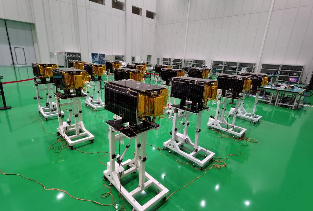
The most revealing picture of China's remote-sensing AI race contains no AI at all. It shows rows of compact Jilin-1 satellites on wheeled stands inside a bright production hall. Xinhua published the photograph in December 2022 while reporting how Chang Guang Satellite Technology had moved from building and testing satellites one at a time toward parallel production.[8] The models arrived downstream of that factory: after the cameras, launches, ground links, calibration work and years of stored observations.
As of July 21, 2026, that upstream chain is becoming the story. The progression from RingMo to SkySense, MaRS and CGEarthEye is often presented as a sequence of larger or more capable vision models. A more useful reading is that the competitive unit has widened. It now includes which sensors produced the pixels, whether optical and radar observations can be paired, how often the same ground is revisited, what spatial detail survives, and who can inspect or reproduce the training archive.[1][2][3][5][7]
This matters because a remote-sensing image is not an ordinary photograph taken from farther away. Optical sensors record reflected light; synthetic-aperture radar records microwave backscatter and can observe through cloud or darkness. A field changes with the season. A building can occupy only a few pixels at one resolution and become a collection of roofs, shadows and edges at another. The emerging field signal is therefore not “add every sensor.” It is learn which observation carries useful information for this task, at this scale, at this moment.
RingMo made the visual domain the first-class object
RingMo's 2022 release marked an early break with a common shortcut: taking a model pretrained on everyday photographs and adapting it to satellite scenes. The Aerospace Information Research Institute of the Chinese Academy of Sciences said its training set contained more than two million unlabeled images spanning roughly 0.1 to 30 metres in resolution, collected from satellite and aerial platforms. The institute also described more than 100 million object instances across over 150 representative cities, towns, airports and ports.[1]
The important contribution was not merely scale. RingMo used masked-image pretraining designed around remote-sensing characteristics such as tiny, densely distributed and arbitrarily oriented objects. It was evaluated on eight standard datasets across classification, detection, recognition, extraction and change-related tasks. That made the initial contract legible: learn a reusable representation of the remote-sensing domain, then attach a task-specific head.[1]
RingMo did not prove that one encoder could understand every sensor or geography. Its benchmark results also did not establish operational performance in a flood, planning office or crop-insurance workflow. What it changed was the baseline. The archive itself—rather than ImageNet-style natural photography—became a strategic training asset.
SkySense showed that the fusion dividend is lopsided
SkySense widened that contract in 2024. Its 2.06-billion-parameter system was pretrained on 21.5 million temporal sequences drawn from high-resolution optical imagery, medium-resolution multispectral observations and synthetic-aperture radar. Separate spatial encoders and a fusion module allowed the model to handle anything from one static optical image to aligned optical–radar time series. The paper evaluated the system across 16 datasets and seven task families.[2]
The decisive idea was that time, modality and location are not interchangeable metadata. They are part of the input. A crop field seen once is an appearance; seen repeatedly, it becomes a growth curve. Radar may preserve a signal when cloud blocks optical observation, but it also carries speckle, layover and a different physical relationship to the ground. Pairing two sensors is therefore not the same as adding another colour channel.
SkySense V2 made the trade-off unusually concrete. On the paper's PASTIS-MM crop-mapping setup, a static Sentinel-2 input scored 75.0. A Sentinel-2 time series raised the result to 85.5. Adding a Sentinel-1 radar time series moved it only to 85.6, while adding high-resolution imagery to the optical time series produced 86.7.[3] On that benchmark, time delivered a 10.5-point gain; radar added 0.1 point after time was present.
That is not a universal ranking of sensors. It is one dataset, task, metric and training setup. In a night-time flood or beneath heavy cloud, radar could be the observation that matters most. The bounded lesson is better: fusion returns depend on the missing information. SkySense V2's shared backbone, modality-specific input handling and temporal fusion should be read as a routing architecture for evidence, not as proof that every available feed should always be fused.[3]
MaRS traded temporal breadth for paired, sub-metre detail
Wuhan University's MaRS, published at AAAI in March 2026, attacks a different weakness. Many multimodal systems rely on medium-resolution Sentinel data; many very-high-resolution systems remain optical-only. MaRS was trained on approximately 16.8 million paired optical–radar patches at about 0.35-metre ground sampling distance. Its cross-granularity training is explicitly designed for the fact that a local radar patch and an optical patch may not align cleanly even when they describe the same place.[5]
This shift changes what the model can plausibly distinguish. At sub-metre resolution, roads, buildings and damage patterns contain fine structure that a ten-metre pixel cannot preserve. The paper tests MaRS as a backbone across registration, missing-modality mapping, translation, damage and change detection, object and building detection, height estimation and road extraction. Those are research benchmarks, not one deployed emergency system, but they expose the intended handoff: from broad scene understanding toward fine-grained interpretation under imperfect visibility.[5]
The accompanying repository is unusually useful because it reveals both openness and its limit. Wuhan University released pretrained optical and radar weights, preprocessing code and a reproducible pretraining pipeline. Yet the repository says the complete roughly five-terabyte MaRS-16M corpus is not publicly available and restricts the release to academic research.[6] An outside team can test the backbone. It cannot reconstruct the full observation archive from the release alone.
CGEarthEye turns constellation access into a model advantage
CGEarthEye makes the upstream move explicit. Its authors are affiliated with Chang Guang Satellite Technology and Jilin University, and the model is designed around the Jilin-1 constellation rather than a generic public imagery mixture. The 2025 paper describes JLSSD, a corpus of 15 million 0.75-metre images sampled from 2023 Jilin-1 coverage. Inside China, it uses quarterly views of the same locations; outside China, it uses annual mosaics. Five model sizes range from 22 million to 1.1 billion parameters.[7]
The seasonal design matters more than the aggregate parameter count. A satellite operator can choose where to collect, how often to revisit, which low-quality observations to reject and how to align updates. CGEarthEye turns those acquisition decisions into a training curriculum: global diversity, repeated domestic observations and fine spatial detail. This is an inference from the paper's data construction, not proof that a proprietary archive always beats open Sentinel data. It does show why sensor ownership can become an AI advantage before architecture enters the comparison.[7]
The production-floor photograph now reads differently. It is not a generic space-industry illustration. Each manufactured satellite adds potential revisit capacity; each revisit can add another season, change pair or rare event to the archive. The factory and the model are separated by years of engineering, but they belong to the same data system.[7][8]
Open weights are not an open observatory
SkySense++ supplies a second warning against equating model access with data reproducibility. The 2025 system used 27 million multimodal images and added a semantic pretraining stage intended to improve few-shot transfer across twelve Earth-observation tasks in seven domains. Its code is public. Its data statement also says some constituent datasets cannot be redistributed under their original agreements, so researchers must obtain access from the underlying providers.[4]
That is not a defect unique to China. High-resolution commercial imagery, national ground-station archives and disaster data often carry legal, security or licensing constraints. But it changes the meaning of “open.” A downloadable checkpoint can support downstream experiments without making the pretraining mixture auditable, refreshable or independently reproducible. In remote sensing, the model card needs a companion record for sensors, acquisition dates, geographic sampling, cloud and quality filters, calibration, licences and missing observations.
Four tests would show that this sensor-archive strategy is maturing beyond benchmark leadership:
- Geographic transfer: hold out regions, climates and settlement patterns rather than randomly splitting nearby patches from the same imagery.
- Sensor and time drift: test new satellite generations, calibration changes, seasons and post-disaster conditions that were absent from pretraining.
- Operational handoff: report latency, uncertainty, false alarms and human review against the numerical or manual workflow a model is meant to improve.
- Reproducible data lineage: publish enough acquisition, filtering and pairing metadata for outsiders to explain a result even when the underlying commercial pixels cannot be redistributed.
The falsifier is straightforward. If models trained on accessible medium-resolution archives consistently match constellation-linked systems on fine-grained, geographically held-out tasks, then sensor ownership is a weaker moat than it appears. If gains disappear under new sensors, seasons or regions, “foundation” is too broad a name for benchmark familiarity. Conversely, durable transfer would confirm that the observation system—not only the encoder—has become a core layer of China's AI capability.
The remote-sensing race is therefore moving in two directions at once. Architectures are learning to route optical, radar, time and resolution more selectively. Institutions are moving upstream toward the archives that make those choices possible. The most consequential model may not be the one with the largest parameter count. It may be the one connected to an observation system that can keep seeing, calibrating and learning after the benchmark has stopped changing.
Sources
- Aerospace Information Research Institute, Chinese Academy of Sciences, “First generative pretraining foundation model for cross-modal remote-sensing data released” (August 22, 2022)—RingMo's data sources, resolution range, self-supervised design and evaluation scope.
- Xin Guo et al., “SkySense: A Multi-Modal Remote Sensing Foundation Model Towards Universal Interpretation for Earth Observation Imagery,” CVPR 2024—model scale, temporal optical–SAR corpus, architecture and evaluation envelope.
- Yingying Zhang et al., “SkySense V2: A Unified Foundation Model for Multi-modal Remote Sensing,” ICCV 2025—shared-backbone design, modality ablations and PASTIS-MM crop-mapping results.
- Kang Wu et al., “A semantic-enhanced multi-modal remote sensing foundation model for Earth observation,” Nature Machine Intelligence 7 (2025)—SkySense++ pretraining, few-shot scope, code and data-access statement.
- Ruoyu Yang et al., “MaRS: A Multi-modality Very-high-resolution Remote Sensing Foundation Model with Cross-Granularity Meta-Modality Learning,” AAAI 2026—paired 0.35-metre corpus, sensor-alignment problem and downstream evaluation scope.
- Wuhan University RSIDEA,
WanderRainy/MaRS—official weights, pretraining code, data-availability limit and academic-use terms. - Zhiwei Yi et al., “CGEarthEye: A High-Resolution Remote Sensing Vision Foundation Model Based on the Jilin-1 Satellite Constellation” (2025)—JLSSD sampling, seasonal design, model family and evaluation setup.
- Xinhua, “The technology behind the development of Jilin-1” (December 14, 2022)—batch-production context and source of the documentary satellite photograph used for this article.